Category
page 1Landforms of Maluku (province)

Banda Sea
Interisland Sea in the Pacific Ocean

Molucca Sea
sea in Indonesia located in the western Pacific Ocean

Seram Sea
sea in Indonesia
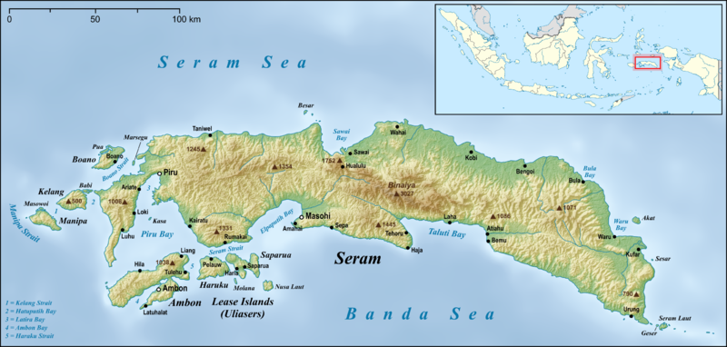
Seram
island in Maluku Province, Indonesia

Buru Island
Buru (formerly spelled Boeroe, Boro, or Bouru) is the third largest island within the Maluku Islands of Indonesia. It lies between the Banda Sea to the south and Seram Sea to the north, west of Ambon and Seram islands. The island belongs to Maluku province and includes the Buru and South Buru regencies. Their administrative centers, Namlea and Namrole, respectively, have ports and are the largest towns of the island, served by Namlea Airport and Namrole Airport respectively.
Banda Islands
island group in Indonesia
Kai Islands
island group of Indonesia
Tanimbar Islands
archipelago located between Banda Sea and Arafura Sea in Indonesia
Aru Islands Regency
regency in Maluku Province, Indonesia
Babar Islands
district in Southwest Maluku Regency, Maluku Province, Indonesia
Barat Daya Islands
island group in Indonesia
Saparua Island
Saparua is an island east of Ambon Island in the Indonesian province of Maluku; the island of Haruku lies between Saparua and Ambon. The main port is in the south at Kota Saparua. The small and uninhabited island of Maolana is located near its southwestern side and Nusa Laut off its southeastern tip.
Leti Islands
island group

Kisar Island
Kisar, also known as Yotowawa, is a small island in the Southwestern Moluccas in Indonesia, located to the northeast of Timor Island. The island now forms two districts ("North Kisar" and "South Kisar") within the Southwest Islands Regency of Maluku Province. South Kisar District was previously called Kecamatan Pulau Pulau Terselatan and at one time included the larger (but less populated) Roma or Romang Island further north, but this with its own outliers was subsequently split off to form its own district (Kecamatan Kepulauan Roma). The rest of the island forms the North Kisar District (Keca
Nuhu Yuthu Island
island in Southeast Maluku Regency, Maluku Province, Indonesia
Haruku Island
island in Central Maluku Regency, Maluku Province, Indonesia
Gunungapi Wetar
volcanic island in Indonesia

Kei Kecil Island
island in Southeast Maluku Regency, Maluku Province, Indonesia

Buano Island
Buano Island (formerly called "Boano") is an island in West Seram Regency, Maluku Province, Indonesia. It is located off the northern coast of the Huamual Peninsula at the western end of Seram Island, across the Boano Strait (Selat Buano). The inhabitants speak the Buano and Luhu languages, as well as Indonesian and Ambonese Malay.
Lautsa Island
island in Central Maluku Regency, Maluku Province, Indonesia
Manipa Island
Manipa Island is an island in West Seram Regency, Maluku Province, Indonesia. It is located 8 km off the western coast of Kelang (from which it is separated by the Kelang Strait) at the western end of Seram Island and 25 km off the western coast of Buru. Including adjacent small islands, it forms an administrative district (kecamatan) within the regency, with its district centre at Masawoi. The district covers an area of 159.71 km2 and had a population of 7,165 at the 2020 Census; the official estimate as at mid 2023 was 7,793.
Tayandu Islands
island group in Indonesia
Letti Island
island in Southwest Maluku Regency, Maluku Province, Indonesia
Lease Islands
island group in Maluku, Indonesia
Moa Island
island in Southwest Maluku Regency, Maluku Province, Indonesia
Teor Island
island in Eastern Seram Regency, Maluku Province, Indonesia
Kelang Island
Kelang Island is an island in West Seram Regency, Maluku Province, Indonesia. It is a mountainous island located off the western tip of Seram Island, just east of Manipa. Sole, located on the northeastern side, and Tahalupu on the western side are the two principal villages. Tonu Jaya is a third village in the southeast of the island. Mount Tonu, the highest point in the island, is an old volcano.
Ambon Bay
bay in Indonesia