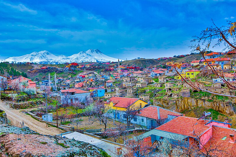
File:Ihlara_-_25936870521.jpg · Wikimedia Commons · See Wikimedia Commons
Aksaray Province is a region located in central Turkey. It matters as part of Turkey's administrative divisions and serves as an area of settlement and economic activity in the country's interior.
AI-generated from the Wikipedia summary — may contain errors.
Wikidata facts
- Instance of
- province of Turkey
- Part of
- Kırıkkale Subregion
- Country
- Turkey
- Located in
- Turkey
- Continent
- Asia
- Capital
- Aksaray
- Official language
- Turkish
- Population
- 390189
- Area
- 7659
- Elevation
- 1050
- Body of water
- Kızılırmak River
- Shares border with
- Kırşehir Province
- Official website
- www.aksaray.gov.tr
- Image
- Aksaray İl Haritası.jpg
- Households
- 130725
- Life expectancy
- 78.11
- Dialing code
- 382
- Licence plate code
- 68
Show 15 more facts
- Commons category
- Aksaray Province
- topic's main category
- Category:Aksaray Province
- native label
- Aksaray ili
- postal code
- 68000–68999
- different from
- Aksaray
- annual number of weddings
- 3219
- male population
- 194936
- female population
- 195253
- suicide rate
- 5.28
- name in kana
- アクサライ
- total fertility rate
- 1.39
- mean age
- 33.05
- minimum temperature record
- -29
- maximum temperature record
- 40.8
- water as percent of area
- 14.81
Sources (15)
via Wikidata · CC0
~4 min read
Encyclopedic overview
Aksaray Province (Turkish: Aksaray ili) is a province in central Turkey. Its adjacent provinces are Konya along the west and south, Ankara to the northwest, Niğde to the southeast, Nevşehir to the east, and Kırşehir to the north. Its area is 7,659 km, and its population is 439.474 (2022). The provincial capital is the city of Aksaray.
Aksaray is one of the four provinces in Cappadocia, along with Nevşehir, Niğde, and Kayseri. Also, the 3,000-metre (9,843 ft) volcano Mount Hasan stands between Aksaray and Niğde. Summers are hot and dry on the plain, but the area is green and covered in flowers in springtime, when water streams off the mountainside. The 2,400 m2 salt lake (0.59 acres), Tuz Gölü, lies within the boundaries of Aksaray, a large swamp area with a maximum depth of 1 metre (3 ft 3 in).
Excerpted from Wikipedia’s “Aksaray Province” article, available under the CC BY-SA 4.0 licence.
Gallery (12)
On the map
Available in 82 languages
- Español
- Français
- Deutsch
- 中文
- 日本語
- Русский
- Português
- Italiano
- العربية
- Albanian
- Armenian
- azb
- Azerbaijani
- Bahasa Indonesia
- Bangla
- Basque
- be_x_old
- Belarusian
Show 63 more
- Bosnian
- Breton
- Bulgarian
- Catalan
- Cebuano
- Central Kurdish
- Chuvash
- Crimean Tatar
- Croatian
- Czech
- Esperanto
- Estonian
- Fiji Hindi
- Filipino
- Finnish
- Galician
- Georgian
- Greek
- Hungarian
- Ido
- Kara-Kalpak
- Kinyarwanda
- Kurdish
- Latin
- Latvian
- lbe
- Macedonian
- Malay
- Marathi
- Mazanderani
- Mingrelian
- Nederlands
- Northern Frisian
- Northern Sami
- Norwegian
- Norwegian Nynorsk
- Ossetic
- Polski
- Romanian
- Scots
- Serbian
- Serbian (Latin)
- Svenska
- Swahili
- Tajik
- Tamil
- Tiếng Việt
- Türkçe
- Turkmen
- Ukrainian
- Urdu
- Uyghur
- Uzbek
- Waray
- Western Mari
- Western Panjabi
- Wu Chinese
- Zaza
- zh_min_nan
- zh_yue
- فارسی
- ไทย
- 한국어
via Wikidata sitelinks · CC0