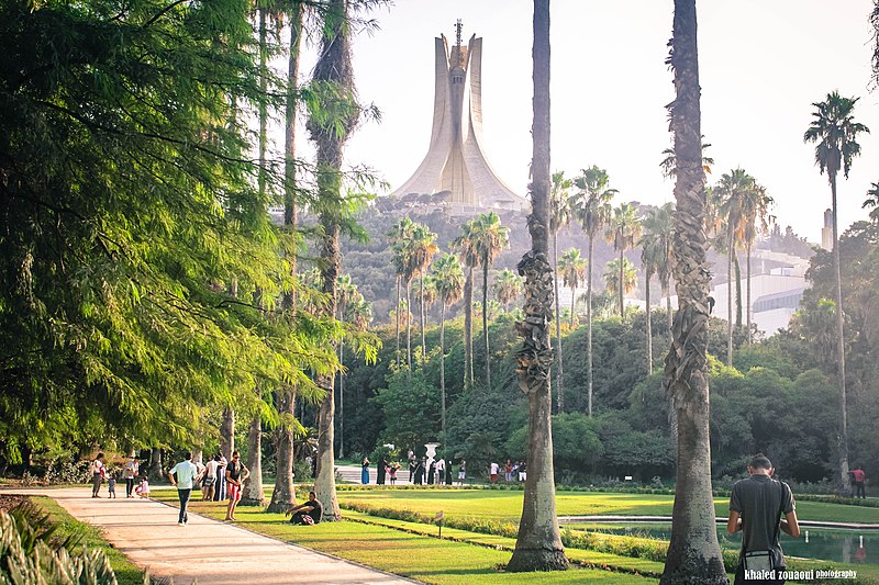
File:Botanical_Garden_Hamma.jpg · Wikimedia Commons · See Wikimedia Commons
Algiers
Sign in to saveAlgiers is the capital city of Algeria, located on the Mediterranean Sea in the north-central portion of the country. In 2025, an estimated 4.325 million people resided within the urban area. Algiers is the largest city in Algeria, the third-largest city on the Mediterranean, the sixth-largest city in the Arab world, and the 29th-largest city in Africa by population. Algiers is the capital of the Algiers Province; it extends over many communes without having its own separate governing body. It extends along the Bay of Algiers surrounded by the Mitidja Plain and major mountain ranges. Its favor
Algiers is the capital and largest city of Algeria, located on the Mediterranean Sea with an estimated population of 4.325 million people as of 2025, making it the third-largest city on the Mediterranean and sixth-largest in the Arab world. The city serves as the political center of Algeria and extends along the Bay of Algiers, surrounded by the Mitidja Plain and major mountain ranges.
AI-generated from the Wikipedia summary — may contain errors.
Weather now
cached 71h ago7-day forecast
via Open-Meteo
Place details
- Locality
- Alger ⴷⵣⴰⵢⴻⵔ الجزائر
- Region
- الجزائر ⴷⵣⴰⵢⴻⵔ
- Country
- ⵍⵣⵣⴰⵢⴻⵔ الجزائر
- Population
- 2,364,230
- Timezone
- Africa/Algiers
via OpenStreetMap · GeoNames
Key facts
- Settlement.leader_name1
- Mahdia Benghalia (since 2021)
- Settlement.established_title
- Incorporated
- Settlement.name
- Algiers
- Settlement.native_name
- الجزائر
- Settlement.native_name_lang
- ar
- Settlement.nicknames
- Algiers the White; Algiers the Dazzling; The White City
- Settlement.image_flag
- Flag of Algiers.svg
- Settlement.image_shield
- Algiers-COA.svg
- Settlement.settlement_type
- Capital city
- Settlement.imagesize
- 290px
- Settlement.pushpin_map
- Algeria#Africa
- Settlement.pushpin_relief
- yes
- Settlement.pushpin_mapsize
- 275
- Settlement.pushpin_map_caption
- Location in Algeria and Africa
- Settlement.subdivision_type
- Country
- Settlement.subdivision_type1
- Province
- Settlement.subdivision_name1
- Algiers
- Settlement.subdivision_name
- Algeria
via Wikipedia infobox
Wikidata facts
- Official name
- الجزائر
- Demonym
- Algéroise
- Population
- 3415811
- Area
- 363
- Elevation
- 0
- Official website
- alger.mta.gov.dz
- Image
- Algiers Montage.png
- Dialing code
- 021
Show 7 more facts
- Commons category
- Algiers
- postal code
- 16000–16132
- Commons gallery
- (الجزائر (مدينة
- native label
- Dzayer
- inception
- 0944-00-00
- P8168
- Zora Folley
- P12749
- Claudius
Sources (9)
via Wikidata · CC0
Travel guide
Understand
The city's name is derived from al-Jazā'ir (Arabic: الجزائر), which is one of two broken plurals of the word jazīra (Arabic: جَزِيرَة, "island").
Get around
Algiers’ public transportation system includes a single metro line, a single tram line, and buses. Taxis are also available, and you can easily find one in the city center.
Do
thumb|Kasbah Of Algiers thumb|Algiers City Center thumb|Algerian Handicrafts
thumb|Palace23 thumb|The Ancient Civilizations Museum Taking a stroll along the beach promenade and park at is a popular family activity.
Buy
Unofficially exchanging money can be done in the Square Port Said and in Abane Ramdane Street, and in some shops in the area such as mobile phone operators. It's an incredibly common practice and transactions are done openly. The exchange rate is typically 40%-50% better than the official rate. People are most interested in exchanging euro. As of March 2024, you can get about DA235 for €1.
Eat
There are several restaurants in the Bois des Arcades area. This is the hill 500 m southeast of the big Martyrs memorial. Particularly good views over Algiers and the coast can be found from here. The hill is also a woodland, so is a nice area for walking too.
Drink
Algeria's red wine is of very high quality and will be appreciated by wine aficionados. It is rarely found on the international market. Locally produced beer is good quality. Alcohol is readily available in hotels, good restaurants and shops.
Travel guide from Wikivoyage (CC BY-SA 4.0)
~53 min read
Article
43 sectionsContents
- Name origin
- History
- Early history
- Medieval history
- Early modern history
- Ottoman rule
- French rule
- Algerian War
- Independence
- Crisis of the 1990s
- Geography
- Location
- Climate
- Climate change
- Administration
- Administrative changes over time
- During French rule
- After Independence
- Districts of Algiers
- Immediate urban districts
- Local architecture
- Monuments
- Demographics
- Economy
- Tourist attractions
- Education
- Infrastructure
- Transport
- Railways
- Sports
- Football clubs
- International relations
- Twin towns – sister cities
- Cooperation agreements
- Films about Algiers
- Notable people
- See also
- Notes
- References
- Citations
- Bibliography
- Further reading
- External links
Algiers is the capital city of Algeria, located on the Mediterranean Sea in the north-central portion of the country. In 2025, an estimated 4.325 million people resided within the urban area. Algiers is the largest city in Algeria, the third-largest city on the Mediterranean, the sixth-largest city in the Arab world, and the 29th-largest city in Africa by population. Algiers is the capital of the Algiers Province; it extends over many communes without having its own separate governing body. It extends along the Bay of Algiers surrounded by the Mitidja Plain and major mountain ranges. Its favorable location made it the center of Ottoman and French influences for the region, shaping it to be a diverse metropolis.
Algiers was formally founded in 972 AD by Buluggin ibn Ziri, though its history goes back to between 1200 and 250 BC as a Phoenician trading settlement. Over time, it came under the control of several powers, including Numidia, the Roman Empire, and various Islamic caliphates. In 1516, it became the capital of the Ottoman Regency of Algiers, a status it held until the French invasion in 1830, after which it served as the capital of French Algeria. During World War II, it briefly functioned as the administrative center of Free France from 1942 to 1944 before returning to French colonial rule. It has remained the capital of the modern Algerian state since the Algerian Revolution in 1962.
Gallery (632)
On the map
31 mapped locations
Available in 180 languages
- Español
- Français
- Deutsch
- 中文
- 日本語
- Русский
- Português
- Italiano
- العربية
- हिन्दी
- Abkhazian
- Adyghe
- Afrikaans
- Akan
- Albanian
- Albanian
- Amharic
- Aragonese
Show 161 more
- Aramaic
- Armenian
- Arpitan
- Asturian
- azb
- Azerbaijani
- Bahasa Indonesia
- Balinese
- Bambara
- Bangla
- Bashkir
- Basque
- bat_smg
- be_x_old
- Belarusian
- Bikol
- Bosnian
- Breton
- Bulgarian
- Burmese
- Catalan
- cdo
- Cebuano
- Central Kurdish
- Chechen
- Chuvash
- Corsican
- Croatian
- Czech
- Danish
- dga
- Egyptian Arabic
- Esperanto
- Estonian
- Extremaduran
- Faroese
- Fiji Hindi
- Filipino
- Finnish
- fiu_vro
- Galician
- Georgian
- Greek
- Haitian Creole
- Hakka Chinese
- Hausa
- Hebrew
- Hungarian
- hyw
- Icelandic
- Ido
- Iloko
- Inari Sami
- Interlingua
- Interlingue
- Irish
- Javanese
- Kabyle
- kai
- Kashubian
- Kazakh
- kbp
- kge
- Kongo
- Kotava
- Kurdish
- Kyrgyz
- Ladino
- Latin
- Latvian
- Ligurian
- Lingala
- Lithuanian
- Lombard
- Low German
- Luxembourgish
- Macedonian
- Maithili
- Malagasy
- Malay
- Malayalam
- Maltese
- Manipuri
- map_bms
- Marathi
- Mazanderani
- Minangkabau
- Mingrelian
- Moksha
- Mongolian
- Moroccan Arabic
- Navajo
- Nederlands
- Nepali
- Northern Frisian
- Norwegian
- Norwegian Nynorsk
- Novial
- Occitan
- Old English
- olo
- Ossetic
- Pampanga
- Papiamento
- Pashto
- Piedmontese
- Polski
- Punjabi
- Romanian
- Santali
- Sardinian
- Scots
- Scottish Gaelic
- Serbian
- Serbian (Latin)
- Shona
- Sicilian
- Silesian
- simple
- Sindhi
- Slovak
- Slovenian
- Somali
- Standard Moroccan Tamazight
- Sundanese
- Svenska
- Swahili
- Tachelhit
- Tajik
- Talysh
- Tamil
- Tatar
- Tibetan
- Tiếng Việt
- Türkçe
- Udmurt
- Ukrainian
- Upper Sorbian
- Urdu
- Uyghur
- Uzbek
- Venetian
- Veps
- Volapük
- Waray
- Welsh
- Western Frisian
- Western Mari
- Western Panjabi
- Wolof
- Wu Chinese
- Yiddish
- Yoruba
- Zaza
- Zeelandic
- zh_min_nan
- zh_yue
- Zulu
- فارسی
- ไทย
- 한국어
via Wikidata sitelinks · CC0