File:Angers_collage.jpg · Wikimedia Commons · See Wikimedia Commons
Angers
Sign in to saveAlso known as Saint-Augustin (réunie à Angers), Saint-Léonard (réunie à Angers), Peu-de-Fonds, Fruits-Sucrés, Gaie-Vallée, Saint-Samson (réunie à Angers)
thumb|right|The Maine (river)|Maine, the castle, and the spires of the cathedral Angers (, , ;) is a city in western France, about southwest of Paris. It is the prefecture of the Maine-et-Loire department and was the capital of the province of Anjou until the French Revolution. The inhabitants of both the city and the province are called Angevins or, more rarely, Angeriens.
OverviewAI-generated
Angers is a commune and big city in France, located in the administrative territorial entity of Maine-et-Loire within the Pays de la Loire region. It serves as the capital of Maine-et-Loire, the arrondissement of Angers, and the canton of Angers-Sud. The city has at various times been part of West Francia, the Kingdom of France, and the Duchy of Anjou. It shares borders with Avrillé, Cantenay-Épinard, Écouflant, and Saint-Barthélemy-d'Anjou.
The population of Angers is 159,022. It covers an area of 42.71 square kilometers and sits at an elevation of 64 meters above sea level. The city is located near the Maine, Mayenne, and Sarthe rivers. Its official postal codes are 49000 and 49100. Angers is twinned with Pisa, Osnabrück, Bamako, and Wigan. The demonym for its residents is Angevin or Angioini.
Synthesized by Vinony from 52 facts across 8 sources: Wikidata, Openweathermap, OpenStreetMap, Firecrawl, GeoNames, Open Meteo, Vinony graph, Geo. Generated from structured data (not the Wikipedia text) and checked against those facts — may still contain errors.
Weather now
7-day forecast
via Open-Meteo
Place details
- Locality
- Angers
- Region
- Pays de la Loire
- Country
- France
- Population
- 168,279
- Timezone
- Europe/Paris
via OpenStreetMap · GeoNames
Key facts
- French commune.name
- Angers
- French commune.commune status
- Prefecture and commune
- French commune.image
- Angers collage.jpg
- French commune.image size
- 280px
- French commune.caption
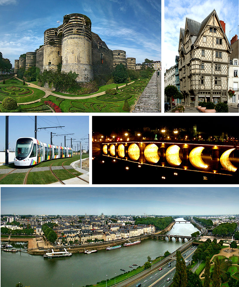
- Top to bottom, left to right: Château d'Angers, ''Maison d'Adam''; Angers tram, Verdun Bridge at night; view of the river Maine, Verdun Bridge and downtown area from Angers Castle
- French commune.image coat of arms
- Coat of Arms of Angers.svg
- French commune.image flag
- Flag of Angers.gif
- French commune.intercommunality
- CU Angers Loire Métropole
- French commune.arrondissement
- Angers
- French commune.canton
- Angers-1, 2, 3, 4, 5, 6, 7
- French commune.population demonym
- Angevin (masculine)Angevine (feminine)
- French commune.INSEE
- 49007
- French commune.postal code
- 49000, 49100
- French commune.mayor
- Christophe Béchu
- French commune.term
- 2024–2026
- French commune.area km2
- 42.70
- French commune.population ranking
- 18th in France
- French commune.urban pop
- 250031
via Wikipedia infobox
Official website
Angers.fr, Site officiel de la Ville d'Angers
Première ville verte de France, Angers cultive sa qualité de vie
angers.fr →Link to the official site · 24,719 chars · not written by Vinony
Wikidata facts
- Instance of
- city
- Official name
- Gaie-Vallée
- Demonym
- Angioini
- Country
- West Francia
- Located in
- county of Anjou
- Population
- 159022
- Area
- 42.71
- Elevation
- 31
- Time zone
- UTC+02:00
- Body of water
- Sarthe
- Capital of
- canton of Angers-7
- Shares border with
- Beaucouzé
- Official website
- www.angers.fr
- Image
- Angers collage.jpg
- Significant event
- Siege of Angers
Show 20 more facts
- postal code
- 49000
- twinned administrative body
- Seville
- Commons category
- Angers
- topic's main category
- Category:Angers
- category for people born here
- Category:Births in Angers
- category for people who died here
- Category:Deaths in Angers
- category of associated people
- Category:People from Angers
- Commons gallery
- Angers
- described by source
- Pauly–Wissowa
- uses
- Qwant
- male population
- 71144
- female population
- 81816
- different from
- Angers
- social media followers
- 50022
- P8168
- Be-Imaan
- email address
- mailto:[email protected]
- contact page URL
- www.angers.fr/services-demarches/contacter-la-mairie/index.html
- phone number
- +33-2-41-05-40-00
- fax number
- +33-2-41-05-39-00
- P12749
- Antipolo
Sources (14)
via Wikidata · CC0
Travel guide
Understand
Located in the French region which was known as Anjou in the Middle Ages, today Angers is a bustling French city, home to around 150,000 people in the city and roughly 270,000 people in the greater metropolitan area. It's a place with great appeal to historians and travellers interested in discovering France's rich medieval history. thumb|A view of the Castle in the evening
Get around
Due to the plan "vigipirate", the national anti-terrorism policy, all luggage storage services around the train and bus station have been suspended.
See
thumbnail|The castle is famous for its black color thumb|upright 1.5|Saint Michael fighting the Dragon - 36th tapestry of the Tapestry of the Apocalypse
Do
Cinemas are Gaumont Variétés (Blvd. Foch), Les Quatre Cent Coups (Rue Clavell) and Gaumont Multiplexe (St. Serge). Football: Angers SCO were promoted in 2024 and now play soccer in Ligue 1, the top tier. Their home ground Stade Raymond Kopa (capacity 18,700) is 1 km southeast of town centre.
Buy
Atoll is a big edge-of-town shopping mall, on the ring-road 5 km west of the centre.
Drink
Since Angers is a university town, there are a lot of bars thronged by young people. Passing via the chateau during night one can see groups of young students going to bars. Soft and Bolero are few notable ones and popular among students community.
Sleep
There is a campsite called Ile du Chateau to the south of the town near the river and for the camper-vanner there is an Aire de Camping-cars.
Connect
As of June 2022, Angers has 5G from all French carriers.
Go next
Nantes - The historical capital of the region. Le Mans - A nearby town best known for its annual 24-hour automobile race.
Travel guide from Wikivoyage (CC BY-SA 4.0)
~48 min read
Encyclopedic overview
35 sectionsContents
- Toponymy
- Etymology
- Nicknames
- Heraldry
- Geography
- Location
- Metropolitan area
- Climate
- Urban morphology
- Green areas
- History
- Prehistory and antiquity
- Middle Ages
- Renaissance
- Classical period
- French Revolution
- Since 1800
- Administration
- Demographics
- Economy
- Health and education
- Transport
- Culture
- Main sights
- Museums
- Entertainment and performing arts
- Media
- Sport
- Notable people
- Twin towns – sister cities
- See also
- Notes
- References
- Further reading
- External links
thumb|right|The Maine (river)|Maine, the castle, and the spires of the cathedral Angers (, , ;) is a city in western France, about southwest of Paris. It is the prefecture of the Maine-et-Loire department and was the capital of the province of Anjou until the French Revolution. The inhabitants of both the city and the province are called Angevins or, more rarely, Angeriens.
Angers proper covers and has a population of 157,555 inhabitants, while around 443,900 live in its metropolitan area (''aire d'attraction''). The Angers Loire Métropole is made up of 29 communes covering with 308,800 inhabitants (2022). Not including the broader metropolitan area, Angers is the third most populous commune in northwestern France after Nantes and Rennes and the 18th most populous commune in France.
Excerpted from Wikipedia’s “Angers” article, available under the CC BY-SA 4.0 licence.
Gallery (53)
On the map
3 mapped locations
Available in 112 languages
- Español
- Français
- Deutsch
- 中文
- 日本語
- Русский
- Português
- Italiano
- العربية
- Achinese
- Afrikaans
- Akan
- Albanian
- Albanian
- Amharic
- Aragonese
- Armenian
- Arpitan
Show 93 more
- Asturian
- azb
- Azerbaijani
- Bahasa Indonesia
- Balinese
- Basque
- Bavarian
- be_x_old
- Belarusian
- Bikol
- Breton
- Buginese
- Bulgarian
- Catalan
- Cebuano
- Chechen
- Chuvash
- Corsican
- Crimean Tatar
- Czech
- dag
- Danish
- Egyptian Arabic
- Esperanto
- Estonian
- Faroese
- Finnish
- Gagauz
- Galician
- Georgian
- Greek
- Haitian Creole
- Hausa
- Hebrew
- Hungarian
- Icelandic
- Ido
- Kotava
- Kurdish
- Latin
- Latvian
- Limburgish
- Lithuanian
- lld
- Lower Sorbian
- Malagasy
- Malay
- Marathi
- Mazanderani
- Nederlands
- Northern Frisian
- Norwegian
- Norwegian Nynorsk
- nrm
- Occitan
- Ossetic
- Piedmontese
- Polski
- Pontic
- Quechua
- Romanian
- Saterland Frisian
- Scots
- Serbian
- Serbian (Latin)
- Silesian
- simple
- Slovak
- Slovenian
- Svenska
- Swahili
- Tatar
- Tiếng Việt
- Türkçe
- Ukrainian
- Upper Sorbian
- Urdu
- Uzbek
- Venetian
- Volapük
- Waray
- Welsh
- West Flemish
- Western Frisian
- Western Mari
- Western Panjabi
- Wu Chinese
- Zaza
- zh_min_nan
- zh_yue
- فارسی
- ไทย
- 한국어
via Wikidata sitelinks · CC0