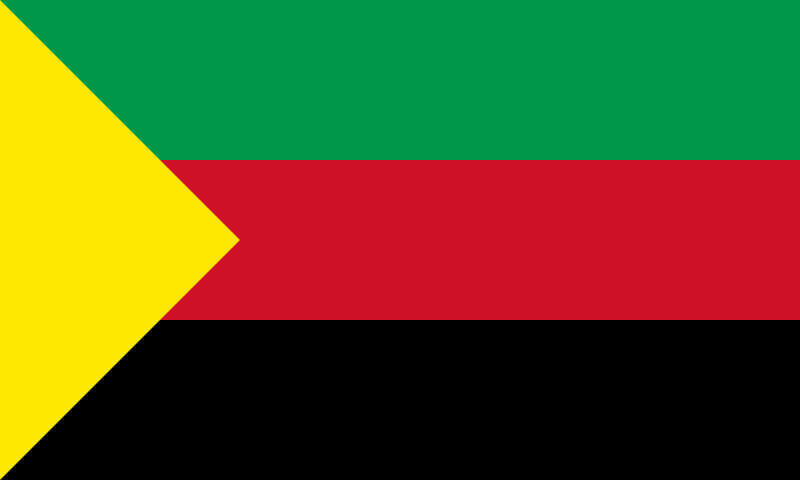
File:MNLA_flag.svg · Wikimedia Commons · See Wikimedia Commons
Azawad
Sign in to saveAlso known as Islamic State of Azawad
thumb|Map of Azawad, as claimed by the National Movement for the Liberation of Azawad|MNLA. Dark grey dots indicate regions with a Tuareg majority. The west is mainly inhabited by Maures, and the south by sub-Saharan peoples. Azawad, or Azawagh (Tuareg: Azawaɣ, or Azawad; ), was a short-lived unrecognised state lasting between 2012 and 2013. The Azawadi declaration of independence was declared unilaterally by the National Movement for the Liberation of Azawad (MNLA) in 2012, after a Tuareg rebellion drove the Malian Armed Forces from the region.
Azawad was a territory in northern Mali that declared independence in 2012 after Tuareg rebels drove out the Malian military, but the state was never internationally recognized and lasted only until 2013. The region, claimed by the independence movement MNLA, is historically inhabited by Tuareg people and other ethnic groups, though the declaration of independence was contested and ultimately unsuccessful.
AI-generated from the Wikipedia summary — may contain errors.
Key facts
- Country.common_name
- Azawad / Azawagh
- Country.conventional_long_name
- Azawad
- Country.status
- Unrecognized state
- Country.p1
- Mali
- Country.flag_p1
- Flag of Mali.svg
- Country.s1
- Mali
- Country.flag_s1
- Flag of Mali.svg
- Country.image_flag
- MNLA flag.svg
- Country.flag_alt
- Flag of Azawad
- Country.flag
- Flag of Azawad
- Country.symbol_type
- Coat of arms
- Country.image_map
- Azawad (orthographic projection).svg
- Country.alt_map
- Projection of Azawad in green and southern Mali in dark grey
- Country.map_caption
- Azawad, as claimed by the MNLA, in green, with southern Mali in dark grey
- Country.capital
- Timbuktu Gao
- Country.largest_city
- Gao
- Country.common_languages
- FrenchFulaHassaniya ArabicSonghayTamasheq
- Country.era
- Northern Mali conflict
via Wikipedia infobox
Wikidata facts
- Instance of
- quasi-state
- Official name
- État indépendant de l’Azawad
- Country
- Mali
- Continent
- Africa
- Capital
- Timbuktu
- Population
- 3000000
- Area
- 932490
- Time zone
- UTC±00:00
- Head of government
- Bilal Ag Acherif
- Official website
- www.mnlamov.net
- Dialing code
- 223
- Flag
- flag of Azawad
Show 5 more facts
- topic's main category
- Category:Azawad
- Commons category
- Azawad
- inception
- 2012-04-06
- dissolved, abolished or demolished date
- 2013-00-00
- native label
- État indépendant de l’Azawad
Sources (3)
via Wikidata · CC0
~21 min read
Encyclopedic overview
21 sectionsContents
- Name
- History
- Under Malian rule
- Independence War
- Unilateral declaration of independence
- Northern Mali conflict
- Peace deal
- Continued insurgency
- 2017
- Geography
- Politics
- Administrative divisions
- Demographics
- Ethnic groups
- Languages
- Religion
- Humanitarian situation
- See also
- References
- Bibliography
- External links
thumb|Map of Azawad, as claimed by the National Movement for the Liberation of Azawad|MNLA. Dark grey dots indicate regions with a Tuareg majority. The west is mainly inhabited by Maures, and the south by sub-Saharan peoples. Azawad, or Azawagh (Tuareg: Azawaɣ, or Azawad; ), was a short-lived unrecognised state lasting between 2012 and 2013. The Azawadi declaration of independence was declared unilaterally by the National Movement for the Liberation of Azawad (MNLA) in 2012, after a Tuareg rebellion drove the Malian Armed Forces from the region.
Azawad, as claimed by the MNLA, comprised the Malian regions of Timbuktu (including present-day Taoudénit Region), Kidal, Gao, as well as a part of Mopti Region, encompassing about 60 percent of Mali's total land area. Gao is its largest city and served as the temporary capital, while Timbuktu is the second-largest city, and was intended to be the capital by the independence forces.
Excerpted from Wikipedia’s “Azawad” article, available under the CC BY-SA 4.0 licence.
Gallery (36)
On the map
3 mapped locations
Available in 85 languages
- Español
- Français
- Deutsch
- 中文
- 日本語
- Русский
- Português
- Italiano
- العربية
- Afrikaans
- Albanian
- Aragonese
- Asturian
- azb
- Bahasa Indonesia
- Bambara
- Bashkir
- Basque
Show 66 more
- Belarusian
- Bosnian
- Breton
- Bulgarian
- Catalan
- Chechen
- Crimean Tatar
- Croatian
- Czech
- Danish
- Egyptian Arabic
- Esperanto
- Estonian
- Filipino
- Finnish
- Gagauz
- Galician
- Georgian
- Greek
- Hebrew
- Hungarian
- Interlingue
- Kyrgyz
- Ladino
- Latin
- Latvian
- Lithuanian
- Lombard
- Macedonian
- Malay
- Marathi
- Mazanderani
- Mingrelian
- Nederlands
- Norwegian
- Norwegian Nynorsk
- Occitan
- Pampanga
- Polski
- Romanian
- Scots
- Serbian
- Serbian (Latin)
- Sicilian
- simple
- Sinhala
- Slovak
- Slovenian
- Standard Moroccan Tamazight
- Sundanese
- Svenska
- Tachelhit
- Tamil
- Tiếng Việt
- Türkçe
- Ukrainian
- Urdu
- Volapük
- Waray
- Wu Chinese
- Zaza
- zh_yue
- Zulu
- فارسی
- ไทย
- 한국어
via Wikidata sitelinks · CC0