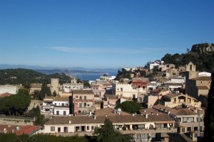
File:Begur,_Spain.jpg · Wikimedia Commons · See Wikimedia Commons
Begur
Sign in to savemunicipality in the comarca of the Baix Empordà in Catalonia, Spain
Key facts
- Country
- Spain
- Autonomous community
- Catalonia
- Province
- Girona
- Comarca
- Baix Empordà
- Mayor
- María Teresa Selva Huertas (2019)
- Total
- 20.7 km (8.0 sq mi)
- Elevation
- 200 m (660 ft)
- Density
- 207/km (537/sq mi)
- Website
- begur .cat
via Wikipedia infobox
Wikidata facts
- Official name
- Begur
- Demonym
- begurenca
- Country
- Spain
- Located in
- Baix Empordà
- Official language
- Catalan
- Population
- 4291
- Area
- 20.70
- Elevation
- 200
- Time zone
- UTC+01:00
- Body of water
- Mediterranean Sea
- Shares border with
- Regencós
- Official website
- www.begur.cat
- Image
- Begur - 2013-07-15 - Albert Torello.jpg
- Households
- 45
- Licence plate code
- GI
Show 10 more facts
- Commons category
- Begur
- catalog code
- 36
- topic's main category
- Category:Begur
- Commons gallery
- Begur
- postal code
- 17213
- inception
- 0600-00-00
- P8168
- dc
- male population
- 1964
- female population
- 1961
- native label
- Begur
Sources (10)
via Wikidata · CC0
~2 min read
Encyclopedic overview
Sa Tuna beach, near Begur Begur ( Catalan pronunciation: [bəˈɣu]) is a village and municipality in the comarca of Baix Empordà and province of Girona in Catalonia, Spain. The village itself lies some 2 kilometres (1.2 mi) from, and 200 metres (660 ft) above, the coastline of the Costa Brava, but the municipality includes several seaside resorts.
The municipality of Begur has 3,986 inhabitants (according to the census of 2005). It is an important tourist attraction in the Baix Empordà. During the summer, the population can exceed 40,000 people.
Excerpted from Wikipedia’s “Begur” article, available under the CC BY-SA 4.0 licence.