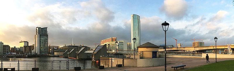
File:City_Quays.jpg · Wikimedia Commons · See Wikimedia Commons
بلفاست
Sign in to saveAlso known as Béal Feirste, Beal Feirste, Belfast, Northern Ireland
پایتخت ایرلند شمالی
Belfast is the capital and main port of Northern Ireland, located on the River Lagan, and serves as the largest city in the region and second-largest on the island of Ireland. The city is significant as a major economic and administrative center, with a substantial metropolitan population of over 671,000 people.
AI-generated from the Wikipedia summary — may contain errors.
Weather now
cached 20h ago7-day forecast
via Open-Meteo
Place details
- Locality
- Belfast
- Region
- Northern Ireland / Tuaisceart Éireann
- Country
- United Kingdom
- Population
- 348,005
- Timezone
- Europe/London
via OpenStreetMap · GeoNames
Key facts
- Settlement.name
- Belfast
- Settlement.settlement_type
- Capital city, district, and borough
- Settlement.image_flag
- File:Flag of Belfast.svg
- Settlement.image_shield
- File:Coat of arms of Belfast.svg
- Settlement.shield_link
- Coat of arms of Belfast
- Settlement.map_caption
- City of Belfast shown within NorthernIreland
- Settlement.mapframe
- yes
- Settlement.mapframe wikidata
- yes
- Settlement.mapframe zoom
- 7
- Settlement.mapframe frame height
- 250
- Settlement.mapframe frame width
- 260
- Settlement.mapframe shape fill opacity
- 0.15
- Settlement.mapframe shape fill
- 0000ff
- Settlement.mapframe caption
- City of Belfast shown within NorthernIreland
- Settlement.subdivision_type
- Sovereign state
- Settlement.subdivision_name
- United Kingdom
- Settlement.subdivision_type1
- Country
- Settlement.subdivision_name1
- Northern Ireland
via Wikipedia infobox
Wikidata facts
- Named after
- River Farset
- Official name
- Béal Feirste
- Demonym
- Belfastčanka
- Country
- United Kingdom
- Located in
- County Down
- Population
- 345006
- Area
- 114.995472
- Elevation
- 3
- Time zone
- UTC±00:00
- Capital of
- Northern Ireland
- Official website
- www.belfastcity.gov.uk
- Image
- Wikibelfast1.jpg
- Dialing code
- 28
- Motto
- Pro Tanto Quid Retribuamus?
Show 14 more facts
- Commons category
- Belfast
- topic's main category
- Category:Belfast
- Commons gallery
- Belfast
- twinned administrative body
- Guadalajara
- category for people born here
- Category:Births in Belfast
- category for people who died here
- Category:Deaths in Belfast
- category for films shot at this location
- Category:Films shot in Belfast
- category of associated people
- Category:People from Belfast
- native label
- Béal Feirste
- historic county
- County Down
- P8168
- Sesto Fiorentino
- social media followers
- 36041
- P12749
- Amsterdam Zuid
- maintained by WikiProject
- WikiProject Ireland
Sources (8)
via Wikidata · CC0
Travel guide
Understand
thumb | 300px | Belfast City Hall
This noble city is named for a mud bank and is built upon sludge. The lower River Lagan is tidal and receives a dozen small tributaries (nowadays culverted) which drop their silt, forming banks of sand and mud. The lowest point at which you could ford the river at low tide is where the Lagan road bridge now crosses, and in Irish this is Béal Feirste, "river-mouth of the sand-bank ford". The tributary joining at that point, the Farset, is likewise named for the mud bank, not vice versa. And besides the man-made channels and culverts, a great volume of water seeps through the alluvial silt on both sides of the Lagan. It's a slimy, thixotropic impediment to building — clay dug out of a trench quickly feels homesick and slides back in — and a deterrent to high-rise; but Paris grew up on similar foundations.
Pre-industrial Belfast was a small provincial place. It grew rapidly in the 18th century with the linen trade, and in the 19th with smokestack industry, especially ship-building along the estuary. It sucked in labour, including Catholics moving off the land. In 1921 Ireland was divided: Dublin and the Republic fell behind economically, while Belfast found itself the capital city of Northern Ireland and, after the Depression, busily tooling up to fight the Second World War.
It slumped in the late 20th century as textiles and smokestack industries were lost to foreign competition. Tension rose between factions and communities, the Catholic m…
Get around
Walk to all the central sights. The centre is within a mile or two of the Botanic Gardens, Queen's University and Titanic.
Do
What's on? Check Visit Belfast as well as individual venue websites. And listen to Belfast 89FM on 89.3 MHz or read The Belfast Telegraph, The Irish News and The News Letter, all published daily. Parks and open spaces: lots and lots. See above for: South: Sir Thomas and Lady Dixon Park, Ormeau Park and Botanic Gardens, and the Lagan towpath to Lisburn. North: Waterworks, Belfast Castle estate, Cave Hill and Alexandra Park West: Dunville and Falls Park, Colin Glen Forest Park and the City and Milltown cemeteries East: Orangefield and Victoria Park
Buy
thumb | 300px | St George's Market Central Belfast has a large retail area, with Castle Court on Millfield to the west through Corn Market to Victoria Square on the east. O'Neills Sportswear are within Castle Court Shopping Centre (M-Sa 9AM-6PM, Su 1-6PM) and at 564 Falls Road BT11 9AE. They stock their own brand sportswear, but their usp is as outlets for Gaelic Sports equipment, jerseys and memorabilia, ideal for a distinctive souvenir. Inns Cross Farmers Market is off Saintfield Rd (A24) south edge of the city near the A55 junction. It's 10AM-2PM on the first Saturday of the month.
Sleep
thumb | 300px | Queens University Belfast
Stay safe
Belfast is for the most part a safe, welcoming city. Though there's trouble beneath the surface, it's locals settling old scores, and tourists aren't involved. After dark you should avoid the "interface areas" noted earlier, and keep your wits about you around Shaftesbury Square (between QUB and Grand Central Station), Botanic Station and Strandtown. Beyond that, just follow the same obvious rules you'd follow in any other big city. Keep your nose and big mouth out of local politics (which stretch back 300 years), and expect some banter if you wear the wrong colour of football jersey. Keep well away from rowdy youths, who may attack unprovoked.
Connect
To call a number in Northern Ireland from the Republic, use area code 048 with no country code. The +44 28 versions given above will work but incur international rates.
As of Jan 2026, the city and its approach roads have 5G from all UK carriers.
There is no land-based mobile signal on the ferries. Switch off in case your phone latches onto the ferry company WiFi, they'll be delighted to connect you at international rates.
Go next
Transport routes radiate from Belfast so virtually all of Northern Ireland is within a day trip. Holywood for the excellent Ulster Folk Museum and Ulster Transport Museum. Hillsborough is a picturesque village, with the grand powerbase of Hillsborough Castle. Giant's Causeway is the standout on the north coast, and can be reached by train or bus. With a car you can meander along the coast via Carrickfergus and Larne into the Antrim Glens and Ballycastle, for ferries to Rathlin Island. The Glens are quiet so the Causeway will feel very touristy by comparison. Derry is a fascinating historic city within its ancient walls. Dublin can be day-tripped by bus or train but deserves much longer.
Travel guide from Wikivoyage (CC BY-SA 4.0)
Gallery (477)
On the map
60 mapped locations
Available in 138 languages
- Español
- Français
- Deutsch
- 中文
- 日本語
- Русский
- Português
- Italiano
- العربية
- हिन्दी
- Afrikaans
- Albanian
- Amharic
- Aragonese
- Armenian
- Asturian
- azb
- Azerbaijani
Show 119 more
- Bahasa Indonesia
- Balinese
- Bangla
- Basque
- be_x_old
- Belarusian
- Betawi
- Bhojpuri
- Bosnian
- Breton
- Bulgarian
- Buriat
- Burmese
- Catalan
- Cebuano
- Central Kurdish
- Chuvash
- Croatian
- Czech
- Danish
- Egyptian Arabic
- Esperanto
- Estonian
- Extremaduran
- Faroese
- Filipino
- Finnish
- Galician
- Georgian
- Greek
- Guarani
- Haitian Creole
- Hebrew
- Hungarian
- Iban
- Icelandic
- Ido
- Interlingua
- Interlingue
- Irish
- Javanese
- Kabyle
- Kannada
- Kazakh
- kge
- Kurdish
- Kyrgyz
- Latin
- Latvian
- Ligurian
- Limburgish
- Lithuanian
- Macedonian
- Malay
- Malayalam
- Maltese
- Manipuri
- Manx
- Marathi
- Mazanderani
- Mongolian
- nds_nl
- Nederlands
- Northern Frisian
- Norwegian
- Norwegian Nynorsk
- nrm
- Occitan
- Ossetic
- Pashto
- Picard
- Piedmontese
- Polski
- Quechua
- Romanian
- Romany
- Sardinian
- Scots
- Scottish Gaelic
- Serbian
- Serbian (Latin)
- Sicilian
- Silesian
- simple
- Sindhi
- Sinhala
- Slovak
- Slovenian
- Standard Moroccan Tamazight
- Svenska
- Swahili
- Tajik
- Talysh
- Tamil
- Tatar
- Tiếng Việt
- Türkçe
- Udmurt
- Ukrainian
- Upper Sorbian
- Urdu
- Uyghur
- Uzbek
- Venetian
- Waray
- Welsh
- West Flemish
- Western Frisian
- Western Panjabi
- Wu Chinese
- Yiddish
- Yoruba
- Zaza
- Zeelandic
- zh_min_nan
- zh_yue
- فارسی
- ไทย
- 한국어
via Wikidata sitelinks · CC0