
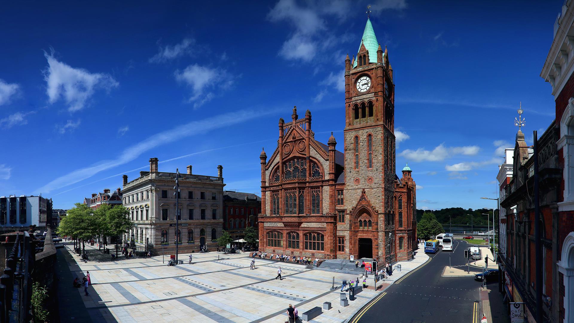
File:DerryMontage3.JPG · Wikimedia Commons · See Wikimedia Commons
Derry
Sign in to saveAlso known as Doire, Derry, Northern Ireland, Londonderry, Derry City
OverviewAI-generated
Derry is a city and border town in the United Kingdom, situated within the administrative entity of Derry City and Strabane in County Londonderry. It serves as the capital of County Londonderry, Derry, and Derry City and Strabane. The city is located next to the River Foyle and has an area of 387. Its official name is Londonderry, and it is distinct from Doire.
The population of Derry is recorded as 85,016. The city uses the postal codes BT47 and BT48 and the local dialing code 028. A significant historical event associated with the location is the Siege of Derry. Derry is described in sources including Brockhaus and Efron Encyclopedic Dictionary, The Nuttall Encyclopædia, Encyclopædia Britannica 11th edition, and Granat Encyclopedic Dictionary.
Synthesized by Vinony from 55 facts across 8 sources: Wikidata, Open Meteo, Openweathermap, OpenStreetMap, Firecrawl, GeoNames, Vinony graph, Geo. Generated from structured data (not the Wikipedia text) and checked against those facts — may still contain errors.
Weather now
7-day forecast
via Open-Meteo
Place details
- Locality
- Derry/Londonderry
- Region
- Northern Ireland / Tuaisceart Éireann
- Country
- United Kingdom
- Population
- 87,153
- Timezone
- Europe/London
via OpenStreetMap · GeoNames
Key facts
- UK place.official_name
- Derry / Londonderry
- UK place.irish_name
- Doire / Doire Cholmcille
- UK place.scots_name
- Derrie / Lunnonderrie
- UK place.local_name
- Maiden City
- UK place.static_image_name
- DerryMontage3.JPG
- UK place.static_image_caption
- From top, left to right: Austin's Department Store, Derry's Walls, Free Derry Corner, Peace Bridge across the River Foyle, a view of Derry at night, Diamond War Memorial, 'Hands Across the Divide' sculpture
- UK place.static_image_2_name
- Londonderry COA.svg
- UK place.static_image_2_width
- 100
- UK place.static_image_2_caption
- "Life, Truth, Victory"(Adapted from a decoration on the Craigavon Bridge)
- UK place.label_position
- none
- UK place.population_ref
- Derry: 85,279 (2021) Urban: 105,066 (2011) Metro: 237,000 (2011)
- UK place.irish_grid_reference
- C434166
- UK place.unitary_northern_ireland
- Derry and Strabane District Council
- UK place.country
- Northern Ireland
- UK place.post_town
- LONDONDERRY
- UK place.postcode_area
- BT
- UK place.postcode_district
- BT47, BT48
- UK place.dial_code
- 028
via Wikipedia infobox
Official website
Derry City & Strabane - Derry City & Strabane District Council
Derry City & Strabane District Council
derrystrabane.com →Link to the official site · 16,409 chars · not written by Vinony
Wikidata facts
- Official name
- Londonderry
- Country
- United Kingdom
- Located in
- Derry
- Population
- 85016
- Area
- 387
- Body of water
- River Foyle
- Capital of
- Derry City and Strabane
- Official website
- www.derrystrabane.com
- Image
- Derry Waterfront - geograph.org.uk - 2166.jpg
- Dialing code
- 028
- Significant event
- Siege of Derry
Show 13 more facts
- Commons category
- Derry
- topic's main category
- Category:Derry (city)
- category for people born here
- Category:Births in Derry
- category for people who died here
- Category:Deaths in Derry
- postal code
- BT48
- category of associated people
- Category:People from Derry (city)
- Commons gallery
- Derry
- historic county
- County Londonderry
- different from
- Doire
- P8168
- Joaquin Wilde
- time of earliest written record
- 0501-00-00
- native label
- Doire
- P12749
- mendelevium
via Wikidata · CC0
Travel guide
Understand
thumb | 300px | Tercentenary Window in Derry Guildhall Accept at the outset that you will occasionally use the wrong name, or rather a right name in the wrong company, and be thunderously corrected. The multiple names of this city reflect its deep layers of history.
Doire is Irish for "oak grove". Glaciers gouged out the fjord of Lough Foyle, and as they retreated the Atlantic lowlands became carpeted in oak forest. Oak was essential so it's a common place-name element: Edenderry, Durrow, Kildare, Adare, and so on. Oak timber was needed for ships, carts, houses, furniture, fences . . . but even more it was needed to make charcoal to fire furnaces for metal-working and glass-blowing. (Coal was too dirty, and coke hadn't been invented.) A monastic settlement grew up at Doire at the head of the lough, while the forests were felled at a rate worthy of a Brazilian cattle tycoon. Meanwhile this northwest region of Ireland remained under Gaelic rule, rebuffing the Vikings, the Normans and the Tudors, until in 1603 Gaelic power was broken by the Nine Years War - almost. But in 1608 a diehard Gaelic noble rebelled, and the city was burned. The rebels were soon hunted down but the government were determined to prevent any repeat. Their astonishing solution was to outsource the place to a London business consortium - how come Nicosia or Sarajevo never thought of this?
Londonderry is the city they ringed with stout walls, soon put to the test. The consortium, "The Honourable The Irish…
Get around
East of the River Foyle is the district of Waterside, predominantly Unionist. The railway station is here and to reach city centre you either take the hourly Bus 2d, or walk across Craigavon Bridge which carries the main road, or take a longer walk via the Peace Bridge downstream.
The main city, bus station and areas of most interest are Cityside, west of the Foyle and mostly nationalist. The city has some steep streets but is compact and walkable; suburbs and industry stretch out beyond.
Taxis wait at the bus and railway stations but you're unlikely to need one. You need your own wheels to explore the countryside, such as Grianan of Aileach prehistoric fort or the Donegal coast of Lough Foyle.
Do
Millennium Forum has the city's largest auditorium, with music, theatre and panto. The Playhouse by St Columb's Cathedral has theatre and music. Cinema: Omniplex is in Quayside Shopping Centre. Institute FC also play soccer at Ryan McBride Stadium. They were relegated in 2020 and now play in the NIFL (Blue Fin Sport) Championship, the game's second tier in Northern Ireland, playing Sep-Apr. thumb | 300px | Only 43 miles to Splodgederry Gaelic games: Derry GAA play Gaelic football and hurling. Their usual home ground is Celtic Park (capacity 18,000) on Lone Moor Rd but home games are also played at other grounds. Golf: nearby courses are Faughan Valley on A2 northeast, City of Derry on A5 south, and Foyle on A2 north along the west river bank.
Buy
thumb | 300px | Craft Village. Foyleside is the large retail mall just south of the bus station, and Richmond Centre is a block northwest. Walled City Market is held in Guildhall Square 11AM–5PM on the first Saturday of the month. Cross-border shopping is sometimes a feature, whenever pound/euro rates or sales tax differences draw shoppers from the Republic.
Drink
thumb | 300px | Trad pubs in Derry The main bar strip is Waterloo Street, a steep street just north of the walls. The Quiet Man Whiskey is blended on Rossdowney Road on Waterside, but construction of their own distillery was abandoned in 2018. Northbound Brewery is on Campsie Industrial Estate next to the airport, no tours. You can buy online but they only deliver within the city area. Otterbank Brewery is on the border at Muff, no tours.
Sleep
thumb | 300px | Griahan of Aileach stone fort
Stay safe
thumb | 300px | Free Derry Corner Derry was scarred by the late 20th century Troubles, and it remains an "interface area" where Republican and Loyalist communities co-exist and occasionally kick off. But it's become a normal city by British and Irish standards, and hasn't seen the need for the kind of "Peace Wall" that still separates neighbourhoods in Belfast. There are down-at-heel districts where you have no reason to go, and aggressive drunks whose politics you need not debate, same as anywhere else. Safeguard your valuables and vehicle, beware traffic, and use your common sense; you'll do fine.
Connect
To call a number in Northern Ireland from the Republic, use area code 048 with no country code. The +44 28 versions given above will work but incur international rates.
As of Aug 2021, Derry has 4G from all UK carriers, which extends some miles into the Republic, especially along Lough Foyle west shore.
It also picks up an Irish 4G signal from Eir and Three, and a mobile signal from Vodafone. Neither side has 5G.
Go next
The County Londonderry coast is scenic: Castlerock has the ruin of an eccentric mansion and "temple". Portstewart is the main beach resort. The Antrim coast east of Portrush has the big attractions of Bushmills Distillery, Giant's Causeway and Carrick-a-Rede Bridge. It's very touristy on summer weekends. County Donegal has a rugged coastline and marks the start of the Wild Atlantic Way: you pick up the signposts for this as you cross the border at Muff.
Travel guide from Wikivoyage (CC BY-SA 4.0)
~63 min read
Encyclopedic overview
60 sectionsContents
- Name
- City walls
- History
- Early history
- Plantation
- 17th-century upheavals
- 18th and 19th centuries
- Early 20th century
- World War I
- Partition
- World War II
- Late 20th century
- 1950s and 1960s
- The civil rights movement
- The Troubles
- Governance
- Coat of arms and motto
- Geography
- Climate
- Demography
- 2011 Census
- 2021 Census
- Protestant minority
- Economy
- History
- Inward investment
- Shopping
- Landmarks
- Transport
- Buses
- Air
- Railways
- Railway history
- 19th century – early 20th century growth
- 20th century decline
- 21st century regeneration
- Road network
- Sea
- Inland waterways
- Education
- Sports
- Association football
- Gaelic football
- Boxing
- Rugby union
- Basketball
- Cricket
- Golf
- Culture
- Media
- Nightlife
- Events
- References in popular music
- Notable people
- Freedom of the City
- Individuals
- See also
- Notes
- References
- External links
Derry, officially Londonderry, is the second-largest city in Northern Ireland. Located in County Londonderry, the city now covers both banks of the River Foyle. Cityside and the old walled city are on the west bank and Waterside is on the east, with two road bridges and one footbridge crossing the river in-between.
The population of the city was 85,279 in the 2021 census, while the Derry Urban Area had a population of 105,066 in 2011. The district administered by Derry City and Strabane District Council contains both Londonderry Port and City of Derry Airport. Derry is close to the border with County Donegal, with which it has had a close link for many centuries. The person traditionally seen as the founder of the original Derry is Saint , a holy man from , the old name for almost all of modern County Donegal, of which the west bank of the Foyle was part of before 1610.
Excerpted from Wikipedia’s “Derry” article, available under the CC BY-SA 4.0 licence.
Gallery (53)
On the map
3 mapped locations
Available in 83 languages
- Español
- Français
- Deutsch
- 中文
- 日本語
- Русский
- Português
- Italiano
- العربية
- Afrikaans
- Aragonese
- Armenian
- azb
- Azerbaijani
- Bahasa Indonesia
- Basque
- Belarusian
- Breton
Show 64 more
- Bulgarian
- Catalan
- Cebuano
- Central Kurdish
- Cornish
- Czech
- Danish
- Egyptian Arabic
- Esperanto
- Estonian
- Filipino
- Finnish
- Galician
- Greek
- Hebrew
- Hungarian
- Icelandic
- Interlingue
- Irish
- Javanese
- Kanuri
- Kazakh
- Kurdish
- Latin
- Latvian
- Lithuanian
- Maltese
- Manipuri
- Manx
- Mazanderani
- Nederlands
- Northern Frisian
- Norwegian
- Norwegian Nynorsk
- Occitan
- Ossetic
- Polski
- Quechua
- Romanian
- Scots
- Scottish Gaelic
- Serbian
- Serbian (Latin)
- Silesian
- simple
- Slovak
- Slovenian
- Svenska
- Tatar
- Tiếng Việt
- Türkçe
- Ukrainian
- Urdu
- Uzbek
- Waray
- Welsh
- Western Frisian
- Western Panjabi
- Wu Chinese
- Zaza
- zh_yue
- فارسی
- ไทย
- 한국어
via Wikidata sitelinks · CC0