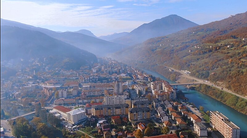
File:Foča_-_Panorama.jpg · Wikimedia Commons · See Wikimedia Commons
OverviewAI-generated
Foča is a city in Bosnia and Herzegovina, serving as the capital of Foča Municipality. It is situated within the Republika Srpska entity and lies next to the Drina river. The city has a population of 12,334 and covers an area of 208 square kilometers. Its elevation above sea level is recorded as 442 meters.
The local postal code is 73300, and the dialing code is 58. Foča operates on Central European Time (UTC+01:00). The city is twinned with Nikšić. It is distinct from the location known as Foča-Ustikolina.
Synthesized by Vinony from 51 facts across 7 sources: Wikidata, Openweathermap, Open Meteo, OpenStreetMap, GeoNames, Vinony graph, Geo. Generated from structured data (not the Wikipedia text) and checked against those facts — may still contain errors.
Weather now
cached 15h ago7-day forecast
via Open-Meteo
Place details
- Locality
- Foča
- Region
- Република Српска / Republika Srpska
- Country
- Bosna i Hercegovina / Босна и Херцеговина
- Population
- 14,615
- Timezone
- Europe/Sarajevo
via OpenStreetMap · GeoNames
Key facts
- Settlement <! more fields are available for this Infobox See Template:Infobox Settlement >.settlement_type
- Town and municipality
- Settlement <! more fields are available for this Infobox See Template:Infobox Settlement >.subdivision_type
- Country
- Settlement <! more fields are available for this Infobox See Template:Infobox Settlement >.subdivision_type1
- Entity
- Settlement <! more fields are available for this Infobox See Template:Infobox Settlement >.subdivision_type2
- Geographical region
- Settlement <! more fields are available for this Infobox See Template:Infobox Settlement >.subdivision_name2
- Podrinje
- Settlement <! more fields are available for this Infobox See Template:Infobox Settlement >.timezone
- CET
- Settlement <! more fields are available for this Infobox See Template:Infobox Settlement >.utc_offset
- +1
- Settlement <! more fields are available for this Infobox See Template:Infobox Settlement >.timezone_DST
- CEST
- Settlement <! more fields are available for this Infobox See Template:Infobox Settlement >.utc_offset_DST
- +2
- Settlement <! more fields are available for this Infobox See Template:Infobox Settlement >.map_caption
- Location of Foča within Bosnia and Herzegovina
- Settlement <! more fields are available for this Infobox See Template:Infobox Settlement >.native_name
- Фоча
- Settlement <! more fields are available for this Infobox See Template:Infobox Settlement >.official_name
- Foča
- Settlement <! more fields are available for this Infobox See Template:Infobox Settlement >.image_shield
- Foča_Coat_of_Arms.jpg
- Settlement <! more fields are available for this Infobox See Template:Infobox Settlement >.image_map
- Foča municipality.svg
- Settlement <! more fields are available for this Infobox See Template:Infobox Settlement >.area_blank1_title
- Town
- Settlement <! more fields are available for this Infobox See Template:Infobox Settlement >.area_blank2_title
- Municipality
- Settlement <! more fields are available for this Infobox See Template:Infobox Settlement >.area_blank2_km2
- 1134.58
- Settlement <! more fields are available for this Infobox See Template:Infobox Settlement >.population_as_of
- 2013 census
via Wikipedia infobox
Wikidata facts
- Instance of
- city
- Country
- Bosnia and Herzegovina
- Located in
- Foča Municipality
- Population
- 12334
- Area
- 208
- Elevation
- 442
- Time zone
- UTC+01:00
- Body of water
- Drina
- Capital of
- Foča Municipality
- Official website
- opstinafoca.rs.ba
- Image
- Foča – Panorama.jpg
- Dialing code
- 58
Show 11 more facts
- Commons category
- Foča
- topic's main category
- Category:Foča
- postal code
- 73300
- native label
- Foča
- category for people born here
- Q32650577
- category of associated people
- Category:People from Foča
- described by source
- Encyclopædia Britannica 11th edition
- different from
- Foča-Ustikolina
- P8168
- Otto Crusius
- twinned administrative body
- Nikšić
- P12749
- Bogotá
Sources (8)
via Wikidata · CC0
Travel guide
Understand
The city lies close to the border with Montenegro and Serbia.
Do
Foča is a good base to explore nature from. For example, to go rafting on the Tara river, running through the deepest canyon in Europe, or go hiking through Perućica forest, one of the last first-growth forests left on the continent, with trees measuring up to 60 m. Also a challenge is to try to climb Maglić Mountain, right on the border with Montenegro. Maglić ("fog") is the highest peak of BiH, and if you make the ascent without a guide, you will probably need 2 days to reach the peak.
The road to Montenegro is used by long distance cyclists. Especially the continuation in Montenegro to Plužine has magnificent views onto the blue river.
Travel guide from Wikivoyage (CC BY-SA 4.0)
Article · Italiano
Foča (in cirillico serbo Фоча) è una città e comune nell'est della Bosnia ed Erzegovina, nonché capoluogo dell'omonima regione, sotto la giurisdizione della Repubblica Serba con 19.811 abitanti al censimento 2013. Rinominata durante la guerra Srbinje riprese il vecchio nome nel 2004 ed è ricordata nel resto della ex-Jugoslavia per il fatto che nel territorio della municipalità ebbe luogo la Battaglia della Sutjeska. Sorge alla confluenza dei fiumi Drina e Ćehotina. Il suo centro storico, che era tra quelli che avevano meglio conservato la tipica impronta ottomana, è stato quasi del tutto distrutto nel 1992 durante la guerra, così come tutte le 12 moschee superstiti della città (5 erano già state distrutte durante la seconda guerra mondiale). Alcune di esse erano considerate di grande valore storico e artistico. Tra i monumenti sopravvissuti si annoverano la (Torre dell'orologio) e il caravanserraglio ottomani. Il 4 maggio 2019 la più celebre delle moschee distrutte, la moschea Aladža, è stata riaperta dopo quasi cinque anni di lavori di ricostruzione.
Abstract from DBpedia / Wikipedia · CC BY-SA
Gallery (34)
On the map
3 mapped locations