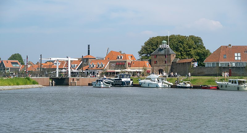
File:Harderwijk,_stadszicht_vanaf_het_Zeepad_IMG_4332_2018-06-27_15.00.jpg · Wikimedia Commons · See Wikimedia Commons
Harderwijk
Sign in to save255px|thumb|Dutch Topographic map of Harderwijk (town), March 2014 Harderwijk (; Dutch Low Saxon: ) is a municipality and city of the Netherlands. It is served by the Harderwijk railway station. Its population centres are Harderwijk and Hierden. Harderwijk is on the western boundary of the Veluwe. The southeastern half of the municipality is largely forests.
Harderwijk is a Dutch city and municipality located on the western edge of the Veluwe region, with two main population centers at Harderwijk and Hierden. The municipality is connected by railway and features forests covering much of its southeastern half.
AI-generated from the Wikipedia summary — may contain errors.
Key facts
- Settlement.name
- Harderwijk
- Settlement.settlement_type
- Municipality
- Settlement.image_skyline
- File:Harderwijk, stadszicht vanaf het Zeepad IMG 4332 2018-06-27 15.00.jpg
- Settlement.image_caption
- Harderwijk, view to the town from het Zeepad
- Settlement.image_flag
- Flag of Harderwijk.svg
- Settlement.flag_size
- 100x67px
- Settlement.image_shield
- Coat of arms of Harderwijk.svg
- Settlement.shield_size
- 100x80px
- Settlement.image_map
- Map - NL - Municipality code 0243 (2009).svg
- Settlement.map_alt
- Highlighted position of Harderwijk in a municipal map of Gelderland
- Settlement.map_caption
- Location in Gelderland
- Settlement.pushpin_map
- Netherlands#Europe
- Settlement.pushpin_map_caption
- Location within the Netherlands##Location within Europe
- Settlement.pushpin_relief
- 1
- Settlement.subdivision_type
- Country
- Settlement.subdivision_name
- Netherlands
- Settlement.subdivision_type1
- Province
- Settlement.subdivision_name1
- Gelderland
via Wikipedia infobox
Wikidata facts
- Instance of
- municipality of the Netherlands
- Official name
- Harderwijk
- Demonym
- Harderwijker
- Country
- Netherlands
- Located in
- Gelderland
- Population
- 50000
- Area
- 38.54
- Elevation
- 3
- Time zone
- UTC+01:00
- Body of water
- Veluwemeer
- Shares border with
- Ermelo
- Official website
- www.harderwijk.nl
- Image
- Harderwijk muziekschool A.jpg
- Households
- 18323
- Dialing code
- 0341
Show 12 more facts
- Commons gallery
- Harderwijk
- twinned administrative body
- Znojmo
- Commons category
- Harderwijk
- postal code
- 3840–3849
- topic's main category
- Category:Harderwijk
- category of associated people
- Category:People from Harderwijk
- category for people born here
- Category:Births in Harderwijk
- native label
- Harderwijk
- email address
- mailto:[email protected]
- phone number
- +31341411911
Sources (14)
via Wikidata · CC0
~5 min read
Encyclopedic overview
6 sectionsContents
- History
- Notable residents
- Sport
- Gallery
- References
- External links
255px|thumb|Dutch Topographic map of Harderwijk (town), March 2014 Harderwijk (; Dutch Low Saxon: ) is a municipality and city of the Netherlands. It is served by the Harderwijk railway station. Its population centres are Harderwijk and Hierden. Harderwijk is on the western boundary of the Veluwe. The southeastern half of the municipality is largely forests.
== History == Harderwijk received city rights from Count Otto II of Guelders in 1231. A defensive wall surrounding the city was completed by the end of that century. The oldest part of the city is near where the streets Hoogstraat and Grote Poortstraat now are. Around 1315 the city was expanded southwards, which included the construction of what is now called the Grote Kerk (Great Church). A second, northward expansion took place around 1425.
Excerpted from Wikipedia’s “Harderwijk” article, available under the CC BY-SA 4.0 licence.
Gallery (16)
On the map
3 mapped locations