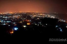
File:Hazaribagh_night_scene.jpg · Wikimedia Commons · See Wikimedia Commons
Hazaribagh
Sign in to saveOverviewAI-generated
Hazaribagh is a city in India, serving as the capital of Hazaribagh district in the state of Jharkhand. It is situated at an elevation of 610 meters above sea level and falls within the UTC+05:30 time zone. The city has a population of 153,595.
Administrative details include the postal code 825301 and the local dialing code 6546. The area is traversed by the NH522 trunk road. Hazaribagh has been described in sources such as the Brockhaus and Efron Encyclopedic Dictionary and the 11th edition of Encyclopædia Britannica.
Synthesized by Vinony from 30 facts across 6 sources: Wikidata, Openweathermap, OpenStreetMap, GeoNames, Vinony graph, Geo. Generated from structured data (not the Wikipedia text) and checked against those facts — may still contain errors.
Weather now
cached 18h ago7-day forecast
via Open-Meteo
Place details
- Region
- Jharkhand
- Country
- India
- Population
- 153,595
- Timezone
- Asia/Kolkata
via OpenStreetMap · GeoNames
Key facts
- Settlement.name
- Hazaribagh
- Settlement.leader_title
- District Magistrate
- Settlement.leader_name
- Smt. Nancy Sahay, IAS
- Settlement.settlement_type
- City
- Settlement.image_caption
- Clockwise from top: Hazaribagh at night, St. Xavier's School, D.A.V Public School, Jama Masjid Hazaribagh, Hazaribagh Road railway station, Hazaribagh town area
- Settlement.pushpin_map
- India Jharkhand#India
- Settlement.pushpin_label_position
- right
- Settlement.pushpin_map_caption
- Location in Jharkhand, India
- Settlement.subdivision_type
- Country
- Settlement.subdivision_type1
- State
- Settlement.subdivision_name1
- Jharkhand
- Settlement.subdivision_type2
- District
- Settlement.subdivision_name2
- Hazaribagh
- Settlement.established_title
- Established
- Settlement.established_date
- 1790
- Settlement.government_type
- Municipal governance in India(municipal corporation)
- Settlement.governing_body
- Hazaribagh Municipal Corporation
- Settlement.unit_pref
- Metric
via Wikipedia infobox
Wikidata facts
- Instance of
- city
- Country
- India
- Located in
- Hazaribagh district
- Population
- 153595
- Elevation
- 610
- Time zone
- UTC+05:30
- Capital of
- Hazaribagh district
- Dialing code
- 6546
Show 5 more facts
- topic's main category
- Category:Hazaribagh
- postal code
- 825301
- Commons category
- Hazaribagh
- described by source
- Encyclopædia Britannica 11th edition
- P12749
- Birmingham
Sources (2)
via Wikidata · CC0
Travel guide
Understand
Temperature (max./min. °C): Summer- 41.1°/19.4° Winter- 25.5°/7° Best season: October to April Best tour time: Early Spring Clothing: Summer - cotton/tropical; winter - light/heavy woolens
Get around
Auto and cycle rickshaws are available. Nowadays, e-rickshaws are also available, and are the cheapest among them all.
Do
It's a peaceful place where you can enjoy the nature.
Eat
Hazaribagh is popular for its street food. You can start your day with local breakfast with kachari sabji and jalebi. Try the locally famous bagheri (a small bird) jhor at Alka Hotel with rice at lunch. This dish often sells out by 12:30. Try out street food of Hazaribagh in the evening. Most famous is the chotangapuri snacks like bada, dhuska, aaloo chop, kachri at the famous local shop at the end of the Guru Teghbahadur Road. Samosa locally called Singhara and rasgulla of Vivekannd Hotel (near Congress Office) is famous for its simple and tasty preparation. Enjoy matka kulfi in summer at Jhanda Chowk. There are plenty of chat serving carts on and around Jhanda Chowk that are famous for samosa and tikki chat. Tikki chat of Hazaribagh is very different from the tikki chat that you get in Delhi. Golgappa is famous in suresh colony of Hazaribahg also tastes differently than what you get in Delhi. Food carts near meetha talab serves hot maal pua and don't forget to drink tea sold in small kiosks all over town.
If you are a non-vegetarian, try out Jama Masjid road and Sujait Chowk area. You can try delicious kabab paratha evening and mouth watering nehari and paya in the morning at Kolkata Hotel (Jama Masjid Chowk). The kabab you find in this area has a distinct taste not what you find in the northern Delhi region. Moreover, you can find tikia (minced meat pressed together and fried), it's an absolute delight and a must if you happen to be in the region.
One more must do is th…
Go next
Hazaribagh National Park — Wildlife enthusiasts would love to visit the national park. Harihar Dham — Interested tourists can follow the main GT road and drive to Hari Har Dham at Bagodhar, famous for the high Shiv Ling, which took 30 years to complete, and is believed to be the tallest in the world. Narsingh sthan (around 10 km) — While going barkagaon around 10 km from main city. There is a temple. You can enjoy beanfeast in guru purnima. Parasnath Temple (90 km) — At the top of the highest hill in Bihar in Giridih district, it's a famous abode for Jain tourists. Bihar State Tourism Development Corporation runs a hotel Paras Vihar for the comfortable stay of the devotees and visitors. Rajrappa — Rajrappa is famous for Ma Chhina Mastika temple, where river Bhera joins the Damodar river from a height of 20 feet. The little waterfall offers boating facilities which introduce some very spectacular rock formations in this area. Surajkund (65 km) — Situated close to the GT Road. You have to get off GT Road at Belkapi near Barkatta, it is quite popular for its steaming-hot hot water springs. Tilaiya Dam (52 km) — It is the first dam and hydroelectric power station constructed by Damodar Valley Corporation across Barakar river in Hazaribag district. It is long and high, in an ideal surrounding with a reservoir stretching for 36 km2. The main objective is to control floods. The hydroelectric station produces…
Travel guide from Wikivoyage (CC BY-SA 4.0)
~18 min read
Encyclopedic overview
21 sectionsContents
- Etymology
- History
- Hazaribagh Town
- Early settlers
- Geography
- Demographics
- Infrastructure
- Climate
- Economy
- Industry
- Education
- Universities
- Colleges
- Schools
- Politics
- Transportation
- Notable people
- Nearby places
- See also
- References
- External links
Hazaribagh is a city and a municipal corporation in Hazaribagh district, Jharkhand, India. It is the administrative headquarters of Hazaribagh district and divisional headquarters of North Chotanagpur division. The city is known as a health resort and for the Hazaribagh Wildlife Sanctuary.
==Etymology== The name of the town 'Hazaribagh' (हज़ारीबाग़) is derived from two Persian words: Hazar (هزار) meaning 'one thousand' and bagh (باغ) meaning 'garden', hence the meaning of Hazaribagh is 'city of a thousand gardens'. According to Sir John Houlton, however, the town takes its name from the small villages of Okni and Hazari – shown on old maps as Ocunhazry.
Excerpted from Wikipedia’s “Hazaribagh” article, available under the CC BY-SA 4.0 licence.
Gallery (8)
On the map
48 mapped locations
Available in 38 languages
- Español
- Français
- Deutsch
- 中文
- 日本語
- Русский
- Italiano
- العربية
- हिन्दी
- Bahasa Indonesia
- Bangla
- Belarusian
- Bhojpuri
- Bishnupriya
- Catalan
- Cebuano
- Esperanto
- Fiji Hindi
Show 19 more
via Wikidata sitelinks · CC0