File:BrehatFrance_(cropped).jpg · Wikimedia Commons · See Wikimedia Commons
Île-de-Bréhat
Sign in to saveAlso known as Enez-Vriad
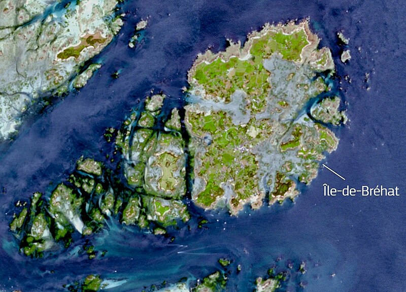
Bréhat (, ; ) is an island and commune located near Paimpol, a mile off the northern coast of Brittany. Administratively, it is a commune in the Côtes-d'Armor department in northwestern France.
OverviewAI-generated
Île-de-Bréhat is a commune in France, situated within the Côtes-d'Armor department and the arrondissement of Saint-Brieuc. The island lies in the English Channel and is located next to the Atlantic Ocean. It is part of the canton of Paimpol and has an official postal code of 22870. The area covers 3.09 square kilometers, with an elevation above sea level of 34 meters.
The population of Île-de-Bréhat is 653, comprising 178 males and 183 females. The commune is in the Europe/Paris timezone. Its official website is iledebrehat.fr, and it can be reached by phone at +33-2-96-20-00-36. The place is described in the Brockhaus and Efron Encyclopedic Dictionary.
Synthesized by Vinony from 50 facts across 7 sources: Wikidata, Open Meteo, Openweathermap, OpenStreetMap, GeoNames, Vinony graph, Geo. Generated from structured data (not the Wikipedia text) and checked against those facts — may still contain errors.
Weather now
cached 18h ago7-day forecast
via Open-Meteo
Place details
- Locality
- Île-de-Bréhat
- Region
- Bretagne
- Country
- France
- Population
- 0
via OpenStreetMap · GeoNames
Key facts
- French commune.name
- Bréhat
- French commune.commune status
- Commune
- French commune.caption
- Views of Bréhat
- French commune.image coat of arms
- COA fr IBR.svg
- French commune.INSEE
- 22016
- French commune.postal code
- 22870
- French commune.arrondissement
- Saint-Brieuc
- French commune.canton
- Paimpol
- French commune.mayor
- Olivier Carré
- French commune.term
- 2020–2026
- French commune.elevation min m
- 0
- French commune.elevation max m
- 34
- French commune.area km2
- 3.09
- French commune.image flag
- Flag of Bréhat.gif
via Wikipedia infobox
Wikidata facts
- Official name
- Île-de-Bréhat
- Country
- France
- Located in
- Côtes-d'Armor
- Population
- 429
- Area
- 3.09
- Elevation
- 11
- Time zone
- UTC+02:00
- Body of water
- Atlantic Ocean
- Official website
- www.iledebrehat.fr
- Image
- Port Clos à Bréhat.jpg
Show 11 more facts
- Commons category
- Île-de-Bréhat
- located in/on physical feature
- Bréhat
- Commons gallery
- Île-de-Bréhat
- postal code
- 22870
- topic's main category
- Category:Île-de-Bréhat
- associated electoral district
- canton of Paimpol
- male population
- 178
- female population
- 183
- P8168
- François Simon
- email address
- mailto:[email protected]
- phone number
- +33-2-96-20-00-36
via Wikidata · CC0
~3 min read
Encyclopedic overview
7 sectionsContents
- Climate
- Population
- Sights
- People linked to Île-de-Bréhat
- See also
- References
- External links
Bréhat (, ; ) is an island and commune located near Paimpol, a mile off the northern coast of Brittany. Administratively, it is a commune in the Côtes-d'Armor department in northwestern France.
Bréhat is actually an archipelago composed of two main islands, separated only at high tide, and many smaller ones. It is famous for its pink granite rocks, very mild micro-climate and Mediterranean vegetation, due to the warm Gulf Stream coming from across the Atlantic.
Excerpted from Wikipedia’s “Île-de-Bréhat” article, available under the CC BY-SA 4.0 licence.
Gallery (12)
On the map
2 mapped locations