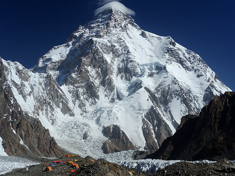
File:Chogori.jpg · Wikimedia Commons · See Wikimedia Commons
Also known as Mount Godwin-Austen, Chhogori, Mount K2, Dapsang, Mt. Qogir
montaña de Pakistán
K2, also known as Mount Godwin-Austen, is the second-highest mountain on Earth after Mount Everest, located in the Karakoram range on the border between Pakistan-administered Kashmir and China-administered Xinjiang. It matters as one of the world's most significant peaks and a major landmark in a geographically and geopolitically important region.
AI-generated from the Wikipedia summary — may contain errors.
Key facts
- Mountain.fetchwikidata
- ALL
- Mountain.name
- K2
- Mountain.elevation_m
- 8611
- Mountain.parent
- Karakoram
- Mountain.map
- China Xinjiang Southern#Gilgit Baltistan
- Mountain.map_caption
- Location of K2 relative to Xinjiang and Gilgit−Baltistan
- Mountain.label_position
- right
- Mountain.country
- Pakistan-administered Kashmir China-administered Trans-Karakoram Tract
- Mountain.first_ascent
- Achille Compagnoni & Lino Lacedelli Nepalese team (winter)
- Mountain.easiest_route
- Abruzzi Spur
- Mountain.mapframe
- no
- Mountain.listing
- Eight-thousanderSeven Second SummitsUltra
- Mountain.etymology
- Second peak measured in the Karakoram Range by the Survey of India, hence "K2" "Mount Godwin-Austen" derives from Henry Godwin-Austen, who first surveyed the peak
via Wikipedia infobox
Wikidata facts
- Instance of
- mountain
- Part of
- ultra-prominent peak
- Named after
- Henry Haversham Godwin-Austen
- Country
- Pakistan
- Located in
- Taxkorgan Tajik Autonomous County
- Elevation
- 8611
- Image
- K - 2 at Day Time.jpg
Show 10 more facts
- category for people who died here
- Category:Deaths on K2
- peak bagging classification
- eight-thousander
- topographic prominence
- 4020
- topographic isolation
- 1316
- Commons gallery
- K2
- mountain range
- Baltoro Muztagh
- Commons category
- K2
- topic's main category
- Category:K2
- described by source
- Encyclopædia Britannica 11th edition
- on focus list of Wikimedia project
- Wikipedia:Vital articles/Level/4
via Wikidata · CC0
Article · Español
El K2 es una montaña perteneciente a la cordillera del Karakórum, en el sistema de los Himalayas. Está a 8611 m s. n. m., y es la segunda montaña más alta de la Tierra, tras el monte Everest (8849 m s. n. m.) y, posiblemente, la más difícil de escalar, junto con el Annapurna y el Nanga Parbat. Se localiza en la frontera entre Pakistán (la vertiente sur, perteneciente a Gilgit, en los Gilgit-Baltistan, antes Territorios del Norte), la zona de Cachemira administrada por los pakistaníes (situada al norte del glaciar Baltoro) y China (la vertiente norte, perteneciente al condado autónomo de Tashkurgán de la prefectura de Kashgar, en la Región Autónoma Uigur de Sinkiang). La India también reivindica la región, considerando que el K2 está íntegramente en su territorio. El K2 se conoce como la montaña salvaje, debido a la dificultad de ascenderla y por ser la segunda en porcentaje de fatalidades entre todos los "ochomiles" para aquellos que lo escalan, después del Annapurna. Por cada cuatro personas que han alcanzado la cumbre, una ha muerto intentándolo. El K2 ha sido el último de los ocho miles en ser escalado en invierno, lo que se consiguió el 16 de enero de 2021.
Abstract from DBpedia / Wikipedia · CC BY-SA
Gallery (33)
On the map
59 mapped locations
Available in 107 languages
- Español
- Français
- Deutsch
- 中文
- 日本語
- Русский
- Português
- Italiano
- العربية
- हिन्दी
- Afrikaans
- Albanian
- Aragonese
- Armenian
- Asturian
- Azerbaijani
- Bahasa Indonesia
- Bangla
Show 88 more
- Bashkir
- Basque
- bat_smg
- be_x_old
- Belarusian
- Bhojpuri
- Bosnian
- Breton
- Bulgarian
- Catalan
- Cebuano
- Cornish
- Croatian
- Czech
- Danish
- Egyptian Arabic
- Esperanto
- Estonian
- Filipino
- Finnish
- Galician
- Georgian
- Greek
- Hebrew
- Hungarian
- Icelandic
- Ido
- Irish
- Javanese
- Kannada
- Kazakh
- Kurdish
- Kyrgyz
- Lao
- Latin
- Latvian
- Lithuanian
- lld
- Macedonian
- Maithili
- Malay
- Malayalam
- Marathi
- Mingrelian
- Nederlands
- Nepali
- Norwegian
- Norwegian Nynorsk
- Occitan
- Pashto
- Polski
- Punjabi
- Romanian
- Romansh
- Scots
- Serbian
- Serbian (Latin)
- simple
- Sindhi
- skr
- Slovak
- Slovenian
- Somali
- Sundanese
- Svenska
- Swahili
- Tajik
- Tamil
- Telugu
- Tiếng Việt
- Toki Pona
- Tulu
- Türkçe
- Ukrainian
- Urdu
- Uyghur
- Uzbek
- Venetian
- Waray
- Welsh
- Western Frisian
- Western Panjabi
- Wu Chinese
- zh_min_nan
- zh_yue
- فارسی
- ไทย
- 한국어
via Wikidata sitelinks · CC0