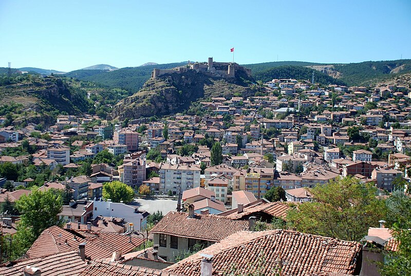
File:Kastamonu1.jpg · Wikimedia Commons · See Wikimedia Commons
Kastamonu
Sign in to saveAlso known as Kastamonu City, Tumana
Kastamonu is a city in northern Turkey. It is the seat of Kastamonu Province and Kastamonu District. Its population is 125,622 (2021). The city lies at an elevation of . It is located in the southern part of the province.
OverviewAI-generated
Kastamonu is a city and municipality located in Kastamonu Province, Turkey. It serves as the capital of the Kastamonu vilayet and has historically been the capital of the Candar dynasty. The city is situated at an elevation of 774 meters above sea level and covers an area of 1,482 square kilometers.
The population of Kastamonu is 152,541, comprising an urban population of 125,622 and a rural population of 124,454. The city uses the postal code 37000 and operates within the Europe/Istanbul time zone. Kastamonu is distinct from Kastamonu Province, which is the broader administrative entity containing the city.
Synthesized by Vinony from 52 facts across 7 sources: Wikidata, Open Meteo, Openweathermap, OpenStreetMap, GeoNames, Vinony graph, Geo. Generated from structured data (not the Wikipedia text) and checked against those facts — may still contain errors.
Weather now
7-day forecast
via Open-Meteo
Place details
- Locality
- Kastamonu Merkez
- Region
- Kastamonu
- Country
- Türkiye
- Population
- 125,622
- Timezone
- Europe/Istanbul
via OpenStreetMap · GeoNames
Key facts
- Turkey place.type
- municipality
- Turkey place.name
- Kastamonu
- Turkey place.image_skyline
- Kastamonu1.jpg
- Turkey place.image_caption
- Kastamonu Castle
- Turkey place.province
- Kastamonu
- Turkey place.district
- Kastamonu
- Turkey place.leader_party
- CHP
- Turkey place.leader_name
- Hasan Baltacı
- Turkey place.elevation_m
- 904
- Turkey place.population_total
- 125622
- Turkey place.population_as_of
- 2021
- Turkey place.area_code
- 0366
- Turkey place.blank1_name
- Climate
- Turkey place.blank1_info
- Dfb
- Turkey place.image_logo
- Kastamonu Belediyesi logo.svg
via Wikipedia infobox
Wikidata facts
- Instance of
- municipality
- Official name
- Kastamonu
- Country
- Turkey
- Located in
- Kastamonu Province
- Population
- 152541
- Area
- 1482
- Elevation
- 774
- Time zone
- time in Turkey
- Capital of
- Candar dynasty
- Official website
- kastamonu.bel.tr
- Image
- Kaleden Cumhuriyet Meydanı ve Çevresi.JPG
Show 15 more facts
- Commons category
- Kastamonu
- topic's main category
- Category:Kastamonu
- category of associated people
- Category:People from Kastamonu
- postal code
- 37000
- Commons gallery
- Kastamonu
- native label
- Kastamonu
- social media followers
- 13672
- P8168
- Philipp Peter
- urban population
- 125622
- rural population
- 26919
- P12749
- Elias gamma coding
- different from
- Kastamonu Province
- maintained by WikiProject
- WikiProject Cities
- located in/on physical feature
- Black Sea Region
- name in kana
- カスタモヌ
Sources (7)
via Wikidata · CC0
Travel guide
Understand
The town may have been founded in the 18th century BC; the Greeks and Romans called it Timonion (Τιμόνιον). It controlled one of the valleys to the Black Sea coast and in the 10th century was fortified by Manuel Erotikos Komnenos (circa 955-1020), so it was dubbed "Kastra Komnenon", hence Kastamonu.
From the 13th to 15th century, Kastamonu was the capital of the Candaroğlu petty kingdom. The Ottomans were already a power in the land, but were almost destroyed by Mongol / Timurid invasion. Thus it was only in 1461 that they'd recovered enough to vanquish the Candaroğlu on their road to establishing an empire on three continents. Kastamonu was thereafter a provincial capital untroubled by warfare. However in the Turkish War of Independence it was a supply hub: western navies embargoed the shipping lanes, but munitions were smuggled into the port of İnebolu, then brought up to Kastamonu, thence to the frontlines.
Get around
The main road follows both banks of the river bisecting the city, with one-way northbound traffic on the east bank and southbound on the west. Public buses ply this strip.
See
thumb | 300px | In the old town Old town straggles along the valley both sides of the Karaçomak River. The southern sections have Ottoman half-timbered houses and stone mansions, plus ancient mosques, caravanserais and bazaars. But it's all a bit scrappy, as most buildings are ticky-tacky modern, and older buildings are often in poor condition, so you don't get the atmosphere of an "old quarter".
Nasrullah Bridge crosses the river east side of Nasrullah Mosque and was built about the same time. It's now a footbridge with two arches remaining; the outer three were clipped off in 1946 to avoid obstructing modern streets along the banks, giving it a lop-sided appearance. Aşir Efendi Hanı (aka Urgan Inn) is a caravanserai just west of Nasrullah Mosque, built in 1748. It's now occupied by small shops but is run-down. - Republic Square - was historically the market place, but is now a plaza lined by public buildings, such as the late Ottoman-style Governor's Office and City Museum. The monument commemorates the effort to supply the front line during the Turkish War of Independence - the foremost figure is Şerife Bacı, who perished from the cold doing so. (Saat Kulesi) on Kuleli Sk is a sturdy sandstone tower of 1885. thumb | 300px | Kastamonu Castle
Do
Hamams: Dede Sultan Hamamı at Atatürk Cd 41 was established in 1524 and is still in business. Others in old town are Çifte Hamam, Arabapazarı Hamam and Yeni (New) Hamam. Lunapark is a rusty crumbling amusement park at the north end of town. It's supposed to be open daily till midnight, but you'll probably find it closed. Dress to impress: it was in Kastamonu on 27 August 1925 that Atatürk made a famous speech banning the wearing of the fez and religious garb; he wore a panama for the occasion. He argued that such dress was not only backward, but it emphasised religious and cultural differences in what should be a unified secular republic. Civil servants and similar officials were thereupon required to wear modern hats, and when Atatürk got back to Ankara he passed a law. There were many protests, and a couple of dozen protesters were hanged, in a modern secular sort of way.
Buy
thumb | 300px | Within Mahmut Bey Mosque Zirve Park is the main shopping centre (AVM), north end of town off Denktaş Cd. It has a big Carrefour open daily 09:00-22:00. Lots of small stores on the streets lining the creek.
Eat
Etli ekmek is a local style of pizza, large and topped by cheese and spicy bacon. It's often served with a soup and a salad. Halva (çekme helvası) is for dessert, in cafes or sold loose. Eating places are found along the streets either side of the creek.
Sleep
thumb | 300px | Nasrullah Bridge The town gets booked out whenever the nearby military garrisons have public parades, as families from all over the country flock to see their conscripted sons looking smart and purposeful. Ruganci Otel next door at Cumhuriyet Cd 14 is less clean. Ramada Resort is on Tufan Sk.
Connect
Kastamonu and its approach highways have 4G from all Turkish carriers. As of April 2024, 5G had not rolled out in Turkey.
Go next
thumb | 300px | Fog rolls in over the Küre Mountains Küre Mountains National Park to the northwest is an area of natural beauty, with lush forests, striking gorges, and biodiversity. İnebolu 92 km north through the mountains is the closest town on the Black Sea. It's mostly modern. Safranbolu to the west is a World Heritage site for its well-preserved old town with whitewashed Ottoman houses. Ilgaz National Park to the south is a winter sports destination, at high altitude having an almost Nordic landscape. Boyabat to the east has an impressive citadel overlooking the river valley.
Travel guide from Wikivoyage (CC BY-SA 4.0)
~7 min read
Encyclopedic overview
14 sectionsContents
- History
- Cuisine
- Economic history
- Education
- Geography
- Climate
- Transport
- Notable natives
- Gallery
- See also
- Notes
- References
- Further reading
- External links
Kastamonu is a city in northern Turkey. It is the seat of Kastamonu Province and Kastamonu District. Its population is 125,622 (2021). The city lies at an elevation of . It is located in the southern part of the province.
== History == thumb|middle|200px|Governor's historical office thumb|middle|200px|Kastamonu old Ottoman houses thumb|middle|200px|Kastamonu Republic Monument thumb|left|200px|Kastamonu University There are many ideas about the derivation of the name Kastamonu:
Excerpted from Wikipedia’s “Kastamonu” article, available under the CC BY-SA 4.0 licence.
Gallery (22)
On the map
3 mapped locations
Available in 63 languages
- Español
- Français
- Deutsch
- 中文
- 日本語
- Русский
- Português
- Italiano
- العربية
- Abkhazian
- Armenian
- Asturian
- azb
- Azerbaijani
- Bulgarian
- Catalan
- Cebuano
- Chechen
Show 44 more
- Chuvash
- Czech
- Egyptian Arabic
- Esperanto
- Finnish
- Gagauz
- Georgian
- Gilaki
- Greek
- Hungarian
- Kinyarwanda
- Latvian
- Lithuanian
- Malay
- Mazanderani
- Minangkabau
- Nederlands
- Norwegian
- Norwegian Nynorsk
- Ossetic
- Polski
- Pontic
- Romanian
- Serbian
- Serbian (Latin)
- simple
- Swahili
- Tajik
- Talysh
- Tatar
- Tiếng Việt
- Türkçe
- Udmurt
- Ukrainian
- Urdu
- Uzbek
- Veps
- Waray
- Western Mari
- Western Panjabi
- Zaza
- zh_min_nan
- فارسی
- 한국어
via Wikidata sitelinks · CC0