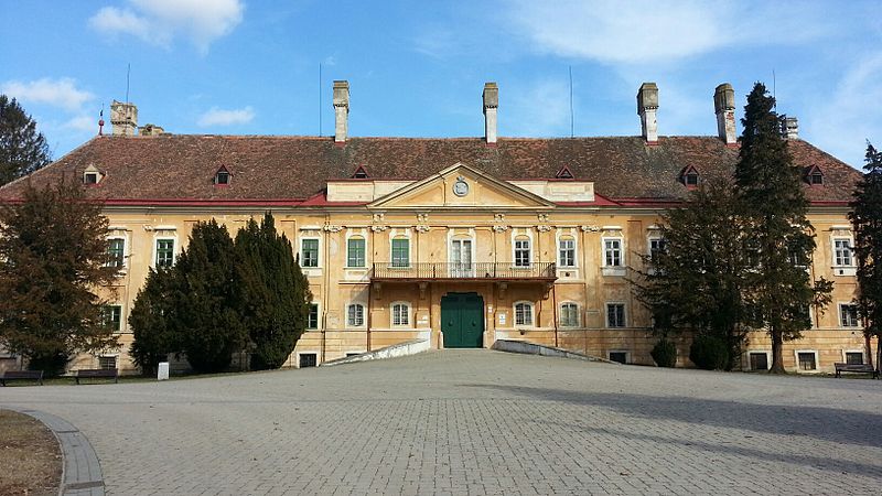
File:MA_kastiel.jpg · Wikimedia Commons · See Wikimedia Commons
Malacky
Sign in to savethumb|right|250px|Synagogue in Malacky Malacky (German: , Hungarian: ) is a town and municipality in western Slovakia around north of Slovakia's capital, Bratislava. From the second half of the 10th century until 1918, it was part of the Kingdom of Hungary.
Key facts
- Slovak place.name
- Malacky
- Slovak place.other_name
- Malacka
- Slovak place.settlement_type
- Municipality
- Slovak place.image_skyline
- MA kastiel.jpg
- Slovak place.image_caption
- Manor-house in Malacky
- Slovak place.image_flag
- Malacky-malacky-flag.svg
- Slovak place.image_shield
- Coat of Arms of Malacky.svg
- Slovak place.subdivision_type1
- Region
- Slovak place.subdivision_type2
- District
- Slovak place.subdivision_name2
- Malacky District
- Slovak place.pushpin_map
- Slovakia Bratislava Region#Slovakia
- Slovak place.pushpin_relief
- 1
- Slovak place.pushpin_map_caption
- Location of Malacky in the Bratislava Region##Location of Malacky in Slovakia
- Slovak place.leader_title
- Mayor
- Slovak place.leader_name
- Juraj Říha
- Slovak place.established_title
- First mentioned
- Slovak place.established_date
- 1231
- Slovak place.elevation_m
- 160
via Wikipedia infobox
Official website
Link to the official site · 11,032 chars · not written by Vinony
Wikidata facts
- Official name
- Malacky
- Population
- 18742
- Area
- 27.172456
- Elevation
- 160
- Official website
- malacky.sk
- Image
- Malacky panorama.jpg
- Dialing code
- 034
- Licence plate code
- MA
Show 6 more facts
- Commons category
- Malacky
- postal code
- 901 01
- native label
- Malacky
- email address
- mailto:[email protected]
- time of earliest written record
- 1206-00-00
- inception
- 1206-00-00
via Wikidata · CC0
~4 min read
Article
12 sectionsContents
- Geography
- Etymology
- History
- Famous buildings and sites
- Economy
- Population
- Ethnicity
- Religion
- People
- Twin towns – sister cities
- References
- External links
thumb|right|250px|Synagogue in Malacky Malacky (German: , Hungarian: ) is a town and municipality in western Slovakia around north of Slovakia's capital, Bratislava. From the second half of the 10th century until 1918, it was part of the Kingdom of Hungary.
It is one of the key cities of the region "Záhorie", between the Little Carpathians in the east and Morava River in the west, and a cultural and economic hub for nearby villages such as Gajary, Kostolište, Veľké Leváre, and Jakubov. The town is located on the large Prague–Brno–Bratislava highway, and many residents commute daily to Bratislava. The Little Carpathians mountain range provides excellent opportunities for recreational activities like hiking or mountain biking, with its wide array of signposted trails.
Gallery (7)
On the map
3 mapped locations