File:Meander-en.svg · Wikimedia Commons · See Wikimedia Commons
meander
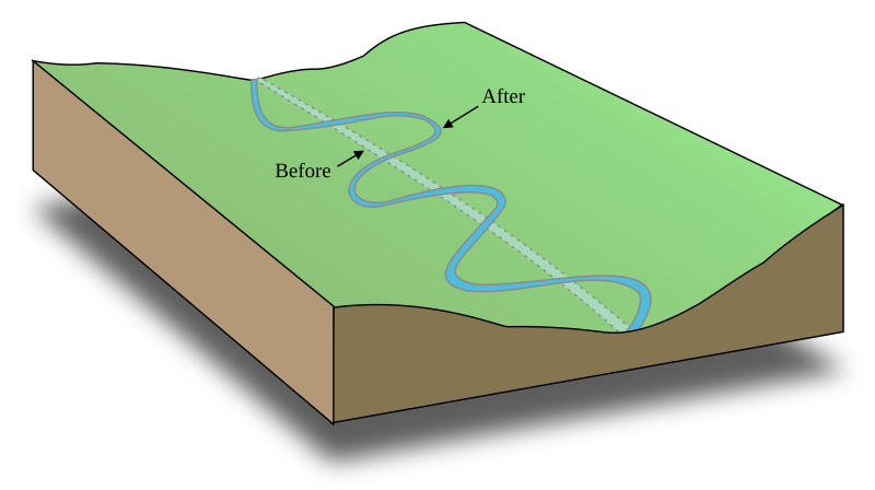
Sign in to saveupright=1.2|thumb|A stream bed following a tilted valley. The maximum gradient is along the down-valley axis represented by a hypothetical straight coast channel. Meanders develop, which lengthen the course of the stream, decreasing the gradient. thumb|Meanders of the Cauto River|Rio Cauto at [[Guamo Embarcadero, Cuba]] thumb|The Jordan River, near the [[Dead Sea, 1937]]
A meander is a winding, curved section of a stream or river that develops as the water follows a longer, more sinuous path instead of flowing straight downhill. Meanders are significant because they reduce the steepness of a stream's gradient, affecting how water flows and shapes the landscape over time.
AI-generated from the Wikipedia summary — may contain errors.
Wikidata facts
- Image
- Nowitna river retusche.jpg
Show 2 more facts
- Commons category
- Meanders
- exact match
- purl.obolibrary.org/obo/ENVO_00000427
Sources (2)
via Wikidata · CC0
~25 min read
Article
20 sectionsContents
- Origin of term
- Governing physics
- Meander geometry
- Formation
- Stochastic theory
- Equilibrium theory
- Geomorphic and morphotectonic theory
- Associated landforms
- Cut bank
- Meander cutoff
- Incised meanders
- Oxbow lakes
- Point bar
- Scroll-bars
- Slip-off slope
- Derived quantities
- See also
- References and notes
- General and cited references
- External links
upright=1.2|thumb|A stream bed following a tilted valley. The maximum gradient is along the down-valley axis represented by a hypothetical straight coast channel. Meanders develop, which lengthen the course of the stream, decreasing the gradient. thumb|Meanders of the Cauto River|Rio Cauto at [[Guamo Embarcadero, Cuba]] thumb|The Jordan River, near the [[Dead Sea, 1937]]
A meander is one of a series of regular sinuous curves in the channel of a river or other watercourse. It is produced as a watercourse erodes the sediments of an outer, concave bank (cut bank or river cliff) and deposits sediments on an inner, convex bank which is typically a point bar. The result of this coupled erosion and sedimentation is the formation of a sinuous course as the channel migrates back and forth across the axis of a floodplain.
Gallery (26)
Available in 74 languages
- Español
- Français
- Deutsch
- 中文
- 日本語
- Русский
- Português
- Italiano
- العربية
- हिन्दी
- Afrikaans
- Albanian
- Albanian
- Aragonese
- Asturian
- Azerbaijani
- Bahasa Indonesia
- Basque
Show 55 more
- bat_smg
- Bhojpuri
- Bosnian
- Bulgarian
- Catalan
- Croatian
- Czech
- Danish
- Esperanto
- Estonian
- Finnish
- Galician
- Georgian
- Haitian Creole
- Hausa
- Hebrew
- Hungarian
- Kazakh
- Kyrgyz
- Latgalian
- Latin
- Latvian
- Limburgish
- Lithuanian
- Luxembourgish
- Macedonian
- Malayalam
- Mingrelian
- Nederlands
- Norwegian
- Norwegian Nynorsk
- Occitan
- Polski
- Punjabi
- Romanian
- Serbian
- Serbian (Latin)
- simple
- Slovak
- Slovenian
- Svenska
- Swahili
- Tamil
- Tiếng Việt
- Türkçe
- Ukrainian
- Welsh
- West Flemish
- Western Frisian
- Western Panjabi
- Wu Chinese
- zh_yue
- فارسی
- ไทย
- 한국어
via Wikidata sitelinks · CC0