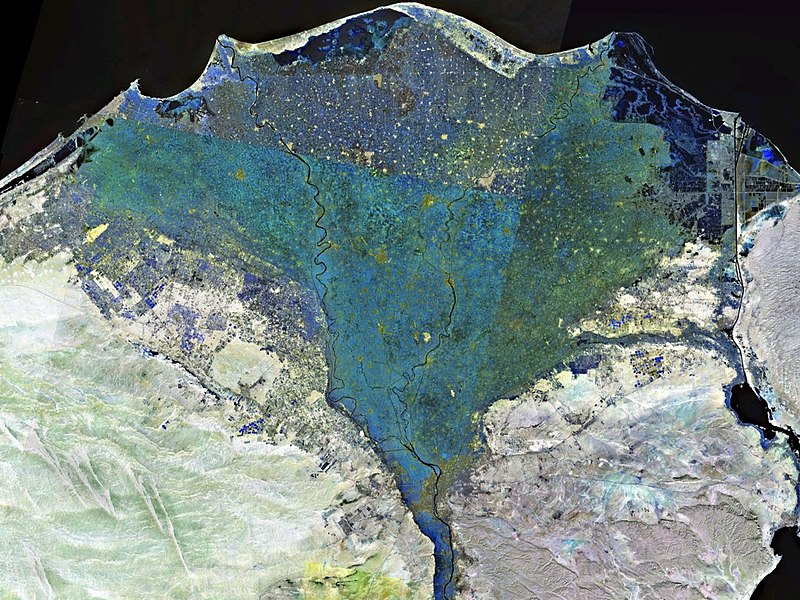
File:Nile_delta_landsat_false_color.jpg · Wikimedia Commons · See Wikimedia Commons
Nile Delta
Sign in to saveAlso known as Delta n-Nīl, ed-Delta
delta formed in Northern Egypt where the Nile River drains into the Mediterranean Sea
The Nile Delta is a flat, fan-shaped region in Northern Egypt where the Nile River spreads out and empties into the Mediterranean Sea. It matters because this fertile area has been one of the world's most important agricultural regions for thousands of years, supporting Egypt's population and civilization.
AI-generated from the Wikipedia summary — may contain errors.
Wikidata facts
- Instance of
- river delta
- Country
- Fatimid Caliphate
- Image
- Nile River and delta from orbit.jpg
Show 5 more facts
- Commons category
- Nile Delta
- topic's main category
- Category:Nile Delta
- delta of
- Nile
- described by source
- Pauly–Wissowa
- P8168
- Pierre Even
via Wikidata · CC0
~9 min read
Encyclopedic overview
NASA satellite photograph of the Nile Delta (shown in false color) The Nile Delta at night as seen from the ISS in October 2010.
The Nile Delta (Arabic: دلتا النيل, Delta an-Nīl or simply الدلتا, ad-Delta) is the delta formed in Lower Egypt where the Nile River spreads out and drains into the Mediterranean Sea. It is one of the world's largest deltas. From Alexandria in the west to Port Said in the east; it covers 240 km (150 mi) of the Mediterranean coastline and is a rich agricultural region. From north to south the delta is approximately 160 km (100 mi) in length. The Delta begins from Cairo.
Excerpted from Wikipedia’s “Nile Delta” article, available under the CC BY-SA 4.0 licence.
Gallery (9)
On the map
Available in 70 languages
- Español
- Français
- Deutsch
- 中文
- 日本語
- Русский
- Português
- Italiano
- العربية
- Afrikaans
- Aramaic
- Armenian
- Avaric
- Azerbaijani
- Bahasa Indonesia
- Basque
- be_x_old
- Belarusian
Show 51 more
- Bhojpuri
- Bosnian
- Bulgarian
- Catalan
- Cebuano
- Croatian
- Czech
- Danish
- Egyptian Arabic
- Esperanto
- Filipino
- Finnish
- Galician
- Georgian
- Greek
- Hebrew
- Icelandic
- Irish
- Javanese
- Kabyle
- Latin
- Latvian
- Limburgish
- Lithuanian
- Malagasy
- Malay
- Malayalam
- Nederlands
- Norwegian
- Norwegian Nynorsk
- Polski
- Romanian
- Serbian
- Serbian (Latin)
- simple
- Sinhala
- Slovak
- Slovenian
- Svenska
- Swahili
- Tamil
- Tiếng Việt
- Türkçe
- Ukrainian
- Urdu
- Waray
- Wu Chinese
- zh_yue
- فارسی
- ไทย
- 한국어
via Wikidata sitelinks · CC0