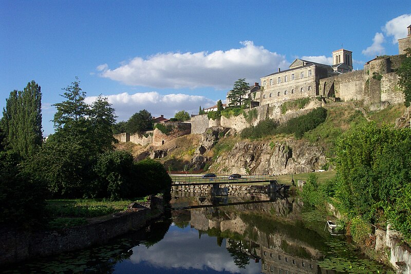
File:Parthenay_Citadel_from_Saint-Paul_Bridge_2.jpg · Wikimedia Commons · See Wikimedia Commons
Parthenay
Sign in to savethumb|right|The Saint-Paul district and the River Thouet from the battlements of the citadel thumb|right|The Saint-Jacques Gate and Bridge, by which mediaeval pilgrims would have entered the town from the north thumb|right|The Rue de la Vau Saint-Jaques from the upper chamber of the Saint-Jacques Gate, with the town centre on the skyline ahead, and the east side of the citadel to the right thumb|right|The Rue de la Vau Saint-Jaques from street level thumb|right|The western town walls thumb|right|Inside the citadel during FLIP 2010; from left to right the Mairie, the ''Porte de l'Horloge, the l
OverviewAI-generated
Parthenay is a commune in France, situated within the Deux-Sèvres department and the Nouvelle-Aquitaine region. It serves as the capital of both the arrondissement of Parthenay and the canton of Parthenay. The municipality has an area of 11.38 square kilometers and an elevation of 184 meters above sea level. Its postal code is 79200, and it shares borders with La Chapelle-Bertrand, Châtillon-sur-Thouet, La Peyratte, and Pompaire.
The population of Parthenay is recorded as 10,902, comprising 4,734 males and 5,533 females. The town is twinned with Weinstadt, Arnedo, Manakara, and Abrantes. It is described in the Encyclopædia Britannica 11th edition and is associated with the canton of Parthenay for electoral purposes.
Synthesized by Vinony from 46 facts across 7 sources: Wikidata, Openweathermap, OpenStreetMap, GeoNames, Open Meteo, Vinony graph, Geo. Generated from structured data (not the Wikipedia text) and checked against those facts — may still contain errors.
Weather now
cached 5h ago7-day forecast
via Open-Meteo
Place details
- Locality
- Parthenay
- Region
- Nouvelle-Aquitaine
- Country
- France
- Population
- 11,599
- Timezone
- Europe/Paris
via OpenStreetMap · GeoNames
Key facts
- French commune.name
- Parthenay
- French commune.commune status
- Subprefecture and commune
- French commune.image
- Parthenay Citadel from Saint-Paul Bridge 2.jpg
- French commune.caption
- The west side of the Partenay citadel from the Saint-Paul Bridge over the River Thouet
- French commune.arrondissement
- Parthenay
- French commune.canton
- Parthenay
- French commune.image coat of arms
- Blason Parthenay.svg
- French commune.INSEE
- 79202
- French commune.postal code
- 79200
- French commune.mayor
- Jean Michel Prieur
- French commune.party
- AC
- French commune.term
- 2020–2026
- French commune.intercommunality
- CC Parthenay-Gâtine
- French commune.elevation min m
- 114
- French commune.elevation max m
- 184
- French commune.area km2
- 11.38
via Wikipedia infobox
Wikidata facts
- Instance of
- commune of France
- Official name
- Parthenay
- Country
- France
- Located in
- Deux-Sèvres
- Population
- 10140
- Area
- 11.38
- Elevation
- 159
- Time zone
- UTC+02:00
- Shares border with
- Châtillon-sur-Thouet
- Official website
- www.parthenay.fr
- Image
- Parthenay Citadel from Saint-Paul Bridge 2.jpg
Show 11 more facts
- twinned administrative body
- Weinstadt
- Commons category
- Parthenay
- postal code
- 79200
- topic's main category
- Category:Parthenay
- described by source
- Encyclopædia Britannica 11th edition
- associated electoral district
- canton of Parthenay
- male population
- 4734
- female population
- 5533
- P8168
- sailfish
- email address
- mailto:[email protected]
- phone number
- +33-5-49-94-03-77
via Wikidata · CC0
~9 min read
Encyclopedic overview
10 sectionsContents
- History
- Geography
- Population
- Government
- Transport
- Main sights
- Climate
- See also
- References
- External links
thumb|right|The Saint-Paul district and the River Thouet from the battlements of the citadel thumb|right|The Saint-Jacques Gate and Bridge, by which mediaeval pilgrims would have entered the town from the north thumb|right|The Rue de la Vau Saint-Jaques from the upper chamber of the Saint-Jacques Gate, with the town centre on the skyline ahead, and the east side of the citadel to the right thumb|right|The Rue de la Vau Saint-Jaques from street level thumb|right|The western town walls thumb|right|Inside the citadel during FLIP 2010; from left to right the Mairie, the ''Porte de l'Horloge, the law courts, and the Église Sainte-Croix.
Parthenay (; Poitevin: Partenaes) is an ancient fortified town and commune in the Deux-Sèvres department of the Nouvelle-Aquitaine region in western France. It is sited on a rocky spur that is surrounded on two sides by the River Thouet, and is the sub-prefecture of the Parthenay arrondissement.
Excerpted from Wikipedia’s “Parthenay” article, available under the CC BY-SA 4.0 licence.
Gallery (15)
On the map
2 mapped locations