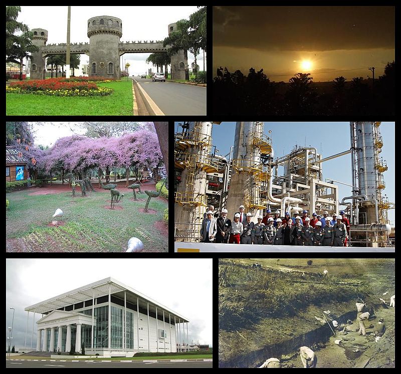
File:Composição-Paulínia.JPG · Wikimedia Commons · See Wikimedia Commons
Paulínia
Sign in to saveAlso known as Paulinia
Paulínia is a Brazilian municipality in the interior of the state of São Paulo. It is located in the northwest of the São Paulo Macrometropolis and is about 119 km from the state capital. It occupies an area of 139 km2 and in 2018, IBGE estimated its population at 106,776. It was emancipated on 28 February 1964, but its foundation dates back to the beginning of the 20th century. The town is named after José Paulino Nogueira, a well-known farmer in the Campinas region, the municipality from which Paulínia emancipated and who lent his name to the railroad station around which the town
Paulínia is a Brazilian municipality in São Paulo state's interior, located about 119 kilometers from the state capital with a population of approximately 106,776 as of 2018. The town, which emancipated in 1964 but traces its origins to the early 1900s, developed around a railroad station and is named after a prominent local farmer from the Campinas region.
AI-generated from the Wikipedia summary — may contain errors.
Key facts
- Settlement.image_caption
- Images of the city of Paulínia: above, left, Medieval Gate; above, right, sunset near rural areas on the border with Cosmópolis; center, left, animals from the ecological park; center, right, Replan employees meeting former president Lula; below, left, the Municipal Theater; and below, right, historical image of workers opening the way for the railroad.
- Settlement.image_flag
- Bandeira de Paulínia - SP.svg
- Settlement.image_seal
- Brasão de Paulínia - SP.svg
- Settlement.image_map
- SaoPaulo Municip Paulinia.svg
- Settlement.map_caption
- Location of Paulinia in São Paulo
- Settlement.pushpin_map
- Brazil
- Settlement.pushpin_map_caption
- Location of Paulinia in Brazil
- Settlement.subdivision_type
- Country
- Settlement.subdivision_type1
- Region
- Settlement.subdivision_type2
- State
- Settlement.subdivision_name
- Brazil
- Settlement.subdivision_name1
- Southeast
- Settlement.subdivision_name2
- São Paulo
- Settlement.subdivision_type3
- Macrometropolis
- Settlement.subdivision_name3
- São Paulo
- Settlement.leader_title
- Mayor
- Settlement.leader_name
- Ednilson Cazellato
- Settlement.established_title
- Founded
via Wikipedia infobox
Wikidata facts
- Instance of
- municipality of Brazil
- Demonym
- paulinense
- Country
- Brazil
- Located in
- São Paulo
- Population
- 36706
- Area
- 139.332
- Elevation
- 590
- Shares border with
- Holambra
- Official website
- www.paulinia.sp.gov.br
- Image
- Theatro Municipal de Paulínia - 1ª Calegaris Run - Prova esportiva de corrida e caminhada na cidade de Paulínia.jpg
- Dialing code
- 019
Show 7 more facts
- Commons category
- Paulínia
- Human Development Index
- 0.795
- inception
- 1964-02-28
- category for films shot at this location
- Category:Films shot in Paulínia
- topic's main category
- Category:Paulínia
- Commons gallery
- Paulínia
- electorate
- 69366
Sources (3)
via Wikidata · CC0
~62 min read
Encyclopedic overview
48 sectionsContents
- Etymology
- History
- Origins
- From village to district
- From district to municipality
- Economic Growth
- Recent History
- Geography
- Relief and geology
- Hydrography
- Climate
- Biodiversity and green areas
- Environmental Problems
- Demography
- Religion
- Politics
- Subdivisions
- Economy
- Primary Sector
- Secondary Sector
- Petrochemical Pole
- Tertiary sector
- Tourism
- Urban Structure
- Security
- Education
- Health
- Communications
- Transportation
- Air Transportation
- Public roads
- Highways
- Collective Transportation
- Railroad Transportation
- Bike paths
- Culture and leisure
- Cuisine
- Arts
- Literature and performing arts
- Sports
- Holidays
- See also
- References
- Bibliography
- Newspapers
- Magazines
- Books
- External links
Paulínia is a Brazilian municipality in the interior of the state of São Paulo. It is located in the northwest of the São Paulo Macrometropolis and is about 119 km from the state capital. It occupies an area of 139 km2 and in 2018, IBGE estimated its population at 106,776. It was emancipated on 28 February 1964, but its foundation dates back to the beginning of the 20th century. The town is named after José Paulino Nogueira, a well-known farmer in the Campinas region, the municipality from which Paulínia emancipated and who lent his name to the railroad station around which the town developed. It is located in the Rio-São Paulo axis, serving as a link between Greater São Paulo and cities in the area, such as Cosmópolis, Artur Nogueira, and Conchal.
It is known for hosting one of the largest petrochemical poles in Latin America, centered on the Paulínia Refinery (Replan). Thanks to Replan and the petrochemical pole, which are based in the northern part of the city, Paulínia has the seventh highest per capita income in Brazil. Also due to the pole, the city presents high levels of ozone pollution, mainly in the district of Betel and in the Replan region, where companies such as Rhodia, Purina, Shell, Syngenta, and Petrobras are located. Paulínia stands out for its intense population growth, the largest in the Metropolitan Region of Campinas. Historically, the service sector has not been very important for the municipality, but recently it has been developing because of projects like Paulínia Magia do Cinema (English: Paulínia Magic of Cinema).
Excerpted from Wikipedia’s “Paulínia” article, available under the CC BY-SA 4.0 licence.
Gallery (52)
On the map
3 mapped locations
Available in 81 languages
- Español
- Français
- Deutsch
- 中文
- 日本語
- Русский
- Português
- Italiano
- العربية
- Afrikaans
- Albanian
- Aragonese
- Asturian
- Aymara
- Azerbaijani
- Bahasa Indonesia
- Basque
- be_x_old
Show 62 more
- Belarusian
- Bishnupriya
- Breton
- Bulgarian
- Catalan
- Cebuano
- Chechen
- Corsican
- Czech
- Danish
- Egyptian Arabic
- eml
- Esperanto
- Extremaduran
- Fiji Hindi
- Filipino
- Finnish
- Galician
- Guarani
- Hebrew
- Icelandic
- Ido
- Irish
- Kazakh
- Latvian
- Lithuanian
- Lombard
- Low German
- Malagasy
- Maltese
- Mazanderani
- Mirandese
- Neapolitan
- Nederlands
- Norwegian
- Norwegian Nynorsk
- Occitan
- Old English
- Pennsylvania German
- Polski
- Romanian
- Scottish Gaelic
- Serbian
- Serbian (Latin)
- Sicilian
- simple
- Slovak
- Sundanese
- Svenska
- Swahili
- Tatar
- Tiếng Việt
- Türkçe
- Ukrainian
- Venetian
- Volapük
- Waray
- Welsh
- Wu Chinese
- zh_min_nan
- فارسی
- 한국어
via Wikidata sitelinks · CC0