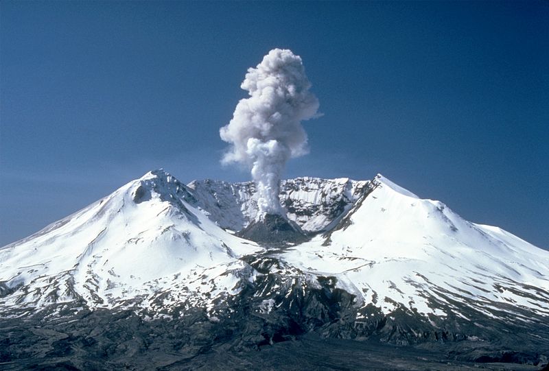
File:MSH82_st_helens_plume_from_harrys_ridge_05-19-82.jpg · Wikimedia Commons · See Wikimedia Commons
Q4675
Sign in to saveAlso known as Goat Rocks dome, Mount Saint Helens, Saint Helens, Mount, Saint Helens, St. Helens
volcano in Washington state
Q4675 is a volcano located in Washington state. It matters because volcanoes in populated regions like Washington can pose risks to nearby communities through eruptions, lava flows, and ash fall.
AI-generated from the Wikipedia summary — may contain errors.
Wikidata facts
- Official name
- Mount St. Helens
- Elevation
- 2549
- Image
- State Route 504 eastbound approaching Mount St. Helens near Castle Lake.jpg
Show 6 more facts
- Commons category
- Mount St. Helens
- Commons gallery
- Mount St. Helens
- topographic prominence
- 1404
- webcam page URL
- www.fs.fed.us/gpnf/volcanocams/msh
- native label
- Lawetlat'la
- name
- Mount Saint Helens
via Wikidata · CC0
~40 min read
Article
Mount St. Helens (known as Lawetlat'la to the local Cowlitz people, and Loowit or Louwala-Clough to the Klickitat) is an active stratovolcano located in Skamania County, Washington, in the Pacific Northwest region of the United States. It lies 52 miles (83 km) northeast of Portland, Oregon, and 98 miles (158 km) south of Seattle. Mount St. Helens takes its English name from that of the British diplomat Alleyne FitzHerbert, 1st Baron St Helens, a friend of explorer George Vancouver who surveyed the area in the late 18th century. The volcano is part of the Cascade Volcanic Arc, a segment of the Pacific Ring of Fire.
The mountain's eruption on May 18, 1980 is the most economically destructive volcanic event in U.S. history. 57 people were killed and 200 homes, 47 bridges, 15 miles (24 km) of railways, and 185 miles (298 km) of highway were destroyed. A massive debris avalanche, triggered by a magnitude 5.1 earthquake, caused a lateral eruption that reduced the elevation of the mountain's summit from 9,677 to 8,363 ft (2,950 to 2,549 m), leaving a 1-mile-wide (1.6 km) horseshoe-shaped crater. The debris avalanche was 0.6 cubic miles (2.5 km) in volume. The 1980 eruption disrupted terrestrial ecosystems near the volcano. By contrast, aquatic ecosystems in the area greatly benefited from the amounts of ash, allowing life to multiply rapidly. Six years after the eruption, most lakes in the area had returned to their normal state.
Gallery (12)
On the map
Available in 78 languages
- Español
- Français
- Deutsch
- 中文
- 日本語
- Русский
- Português
- Italiano
- العربية
- हिन्दी
- Afrikaans
- Albanian
- Asturian
- Azerbaijani
- Bahasa Indonesia
- Bangla
- Bashkir
- Basque
Show 59 more
- Belarusian
- Bulgarian
- Catalan
- Cebuano
- Croatian
- Czech
- Danish
- Esperanto
- Estonian
- Faroese
- Filipino
- Finnish
- Galician
- Georgian
- Greek
- Hawaiian
- Hebrew
- Hungarian
- Icelandic
- Ido
- Irish
- Kurdish
- Latin
- Latvian
- Lithuanian
- lld
- Macedonian
- Malay
- Malayalam
- Marathi
- Nederlands
- Nepali
- Northern Frisian
- Norwegian
- Norwegian Nynorsk
- Occitan
- Polski
- Romanian
- Romansh
- Serbian
- Serbian (Latin)
- simple
- Slovak
- Slovenian
- Svenska
- Swahili
- Tamil
- Tiếng Việt
- Türkçe
- Ukrainian
- Urdu
- Uzbek
- Waray
- Welsh
- Wu Chinese
- zh_yue
- فارسی
- ไทย
- 한국어
via Wikidata sitelinks · CC0