File:Panorama_della_valle_di_anterselva.jpg · Wikimedia Commons · See Wikimedia Commons
Rasen-Antholz
Sign in to saveAlso known as Rasun-Anterselva, Rasen Antholz, Rasun Anterselva
Rasen-Antholz (; ) is a municipality in South Tyrol in northern Italy.
Rasen-Antholz is a small town located in South Tyrol, a region in the northern part of Italy. It serves as a local municipality within this Alpine area of Italy.
AI-generated from the Wikipedia summary — may contain errors.
Key facts
- Italian comune.name
- Rasen-Antholz
- Italian comune.official_name
- Gemeinde Rasen-AntholzComune di Rasun-Anterselva
- Italian comune.image_skyline
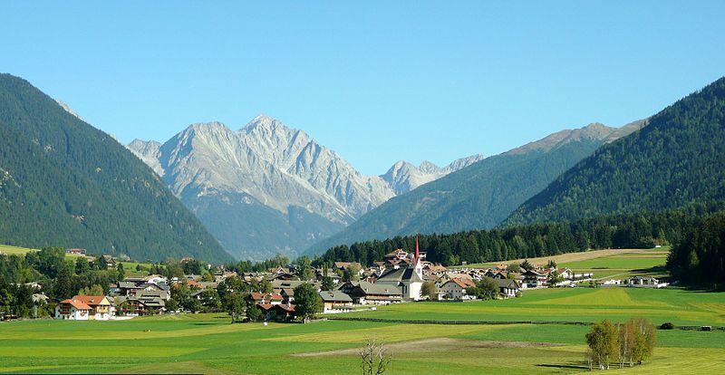
- Panorama della valle di anterselva.jpg
- Italian comune.image_caption
- Niederrasen in October 2011
- Italian comune.image_shield
- CoA civ ITA Antholz-RasunAnterselva.svg
- Italian comune.region
- Trentino-Alto Adige/Südtirol
- Italian comune.province
- South Tyrol (BZ)
- Italian comune.frazioni
- Antholz Niedertal (Anterselva di Sotto), Antholz Mittertal (Anterselva di Mezzo), Antholz Obertal (Anterselva di Sopra), Neunhäusern (Nove Case), Niederrasen (Rasun di Sotto), Oberrasen (Rasun di Sopra)
- Italian comune.mayor
- Thomas Schuster (SVP)
- Italian comune.area_total_km2
- 121.1
- Italian comune.population_total
- 2939
- Italian comune.population_as_of
- 31 October 2025
- Italian comune.population_demonym
- German: Rasner or AntholzerItalian: di Rasun-Anterselva
- Italian comune.elevation_m
- 1030
- Italian comune.postal_code
- 39030
- Italian comune.area_code
- 0474
via Wikipedia infobox
Wikidata facts
- Official name
- Rasen-Antholz / Rasun Anterselva
- Demonym
- anterselvani
- Country
- Italy
- Located in
- South Tyrol
- Contains
- Neunhäusern
- Official language
- Italian
- Population
- 2909
- Area
- 121.57
- Elevation
- 1030
- Time zone
- UTC+02:00
- Shares border with
- Sankt Jakob in Defereggen
- Official website
- www.comune.rasunanterselva.bz.it
- Image
- Panorama della valle di anterselva.jpg
- Dialing code
- 0474
- Licence plate code
- BZ
Show 8 more facts
- Commons category
- Rasen-Antholz
- postal code
- 39030
- topic's main category
- Category:Rasen-Antholz
- category of associated people
- Category:People from Rasen-Antholz
- Commons gallery
- Rasen-Antholz
- member of
- Climate Alliance
- native label
- Rasen-Antholz
- P11012
- Joe DiMaggio
Sources (9)
via Wikidata · CC0
~4 min read
Encyclopedic overview
9 sectionsContents
- Geography
- Frazioni
- Linguistic distribution
- History
- Coat-of-arms
- Sports
- Notable people
- References
- External links
Rasen-Antholz (; ) is a municipality in South Tyrol in northern Italy.
==Geography== thumb|left|Antholz valley The municipal area stretches along the Antholz valley, a northern side valley of the larger Puster Valley. In the northeast, the Staller Saddle mountain pass, at a height of leads into the Defereggen Valley in East Tyrol, Austria. The Antholz valley is confined by the mountains of the Rieserferner Group in the north and the Villgraten Mountains in the east, both part of the High Tauern range in the Central Eastern Alps. Notable peaks include the Hochgall, at , and the Wildgall (Collaspro), at , as well as the Ohrenspitzen massif, at , in the northeast. Large parts of the northern and western mountain ranges belong to the Rieserferner-Ahrn Nature Park established in 1988. The Antholzer Bach stream runs through the valley from Antholzer See (Lago di Anterselva) down to its confluence with the Rienz (Rienza) river at Olang.
Excerpted from Wikipedia’s “Rasen-Antholz” article, available under the CC BY-SA 4.0 licence.
Gallery (8)
On the map
2 mapped locations
Available in 59 languages
- Español
- Français
- Deutsch
- 中文
- 日本語
- Русский
- Português
- Italiano
- العربية
- Armenian
- azb
- Basque
- Bavarian
- Belarusian
- Bosnian
- Breton
- Bulgarian
- Catalan
Show 40 more
- Cebuano
- Chechen
- Czech
- Esperanto
- Estonian
- Filipino
- Finnish
- Greek
- Hungarian
- Interlingua
- Kazakh
- Kurdish
- Latin
- Latvian
- Lithuanian
- lld
- Lombard
- Malay
- Neapolitan
- Nederlands
- Norwegian
- Norwegian Nynorsk
- Piedmontese
- Polski
- roa_tara
- Romanian
- Serbian
- Serbian (Latin)
- Sicilian
- Slovak
- Svenska
- Tatar
- Tiếng Việt
- Türkçe
- Ukrainian
- Venetian
- Volapük
- Waray
- فارسی
- 한국어
via Wikidata sitelinks · CC0