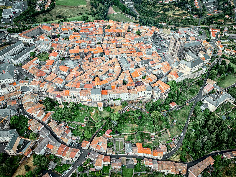
File:Saint-Flour_vue_du_ciel.jpg · Wikimedia Commons · See Wikimedia Commons
Saint-Flour
Sign in to saveAlso known as Sant Flor, Fort-Cantal, Fort-Libre, Mont-Flour
Saint-Flour (; Auvergnat: Sant Flor) is a commune in the south-central French department of Cantal, approximately 100 km south of Clermont-Ferrand. Its inhabitants are called Sanflorains.
OverviewAI-generated
Saint-Flour is a commune in France, situated within the arrondissement of Saint-Flour and the department of Cantal. It serves as the capital of the cantons of Saint-Flour-Sud, Saint-Flour-Nord, and Saint-Flour-2. The town shares borders with Alleuze, Andelat, Coren, and Roffiac. Its official names include Saint-Flour, Fort-Cantal, Fort-Libre, and Mont-Flour, and it is named after Florus.
The commune has a population of 7,950, comprising 2,945 males and 3,490 females. It covers an area of 27.14 square kilometers and stands at an elevation of 1,040 meters above sea level. French and Occitan are the languages used in the area. Saint-Flour is twinned with Haselünne and Orléans.
Synthesized by Vinony from 57 facts across 8 sources: Wikidata, Open Meteo, Openweathermap, OpenStreetMap, GeoNames, Firecrawl, Vinony graph, Geo. Generated from structured data (not the Wikipedia text) and checked against those facts — may still contain errors.
Weather now
cached 14h ago7-day forecast
via Open-Meteo
Place details
- Locality
- Saint-Flour
- Region
- Auvergne-Rhône-Alpes
- Country
- France
- Population
- 7,499
- Timezone
- Europe/Paris
via OpenStreetMap · GeoNames
Key facts
- French commune.name
- Saint-Flour
- French commune.commune status
- Subprefecture and commune
- French commune.image
- Saint-Flour vue du ciel.jpg
- French commune.caption
- Aerial view of Saint-Flour
- French commune.image flag
- Flag of Saint Flour, Cantal.svg
- French commune.image coat of arms
- Blason_ville_fr_Saint-Flour_(Cantal).svg
- French commune.arrondissement
- Saint-Flour
- French commune.canton
- Saint-Flour-1 and 2
- French commune.INSEE
- 15187
- French commune.postal code
- 15100
- French commune.mayor
- Philippe Delort
- French commune.term
- 2020–2026
- French commune.intercommunality
- Saint-Flour Communauté
- French commune.elevation m
- 783
- French commune.elevation min m
- 757
- French commune.elevation max m
- 1040
- French commune.area km2
- 27.14
via Wikipedia infobox
Official website

Accueil - Ville de Saint-Flour
Bienvenue Saint-Flour, une ville au cœur du Cantal. Retrouvez toutes les infos sur la mairie, les événements... Vivez Saint-Flour au quotidien !
saint-flour.net →Link to the official site · 4,083 chars · not written by Vinony
Wikidata facts
- Instance of
- commune of France
- Named after
- Florus
- Official name
- Mont-Flour
- Country
- France
- Located in
- Cantal
- Population
- 6390
- Area
- 27.14
- Elevation
- 870
- Time zone
- UTC+02:00
- Shares border with
- Villedieu
- Official website
- www.pays-saint-flour.fr
- Image
- Saint-Flour depuis les berges de L'Ander.jpg
Show 14 more facts
- Commons category
- Saint-Flour (Cantal)
- postal code
- 15100
- twinned administrative body
- Orléans
- topic's main category
- Category:Saint-Flour (Cantal)
- category for people born here
- Category:Births in Saint-Flour (Cantal)
- different from
- Saint-Flour-l'Étang
- male population
- 2945
- female population
- 3490
- P8168
- Montanoceratops
- language used
- Occitan
- email address
- mailto:[email protected]
- phone number
- +33-4-71-60-61-20
- fax number
- +33-4-71-60-68-47
- described by source
- Encyclopædia Britannica 11th edition
Sources (8)
via Wikidata · CC0
~5 min read
Encyclopedic overview
13 sectionsContents
- Geography
- History
- Middle Ages
- French Revolution
- Population
- Notable natives
- École d'Eté de Probabilités
- Monuments
- Climate
- Gallery
- See also
- References
- External links
Saint-Flour (; Auvergnat: Sant Flor) is a commune in the south-central French department of Cantal, approximately 100 km south of Clermont-Ferrand. Its inhabitants are called Sanflorains.
== Geography == The upper city (ville haute) of Saint-Flour is located on the abrupt volcanic dike Planèze, the lower city (ville basse or "Faubourg") extends on the banks of the Ander.
Excerpted from Wikipedia’s “Saint-Flour” article, available under the CC BY-SA 4.0 licence.
Gallery (9)
On the map
2 mapped locations