File:Siliguri_view_3.jpg · Wikimedia Commons · See Wikimedia Commons
Siliguri
Sign in to saveAlso known as Shiliguri
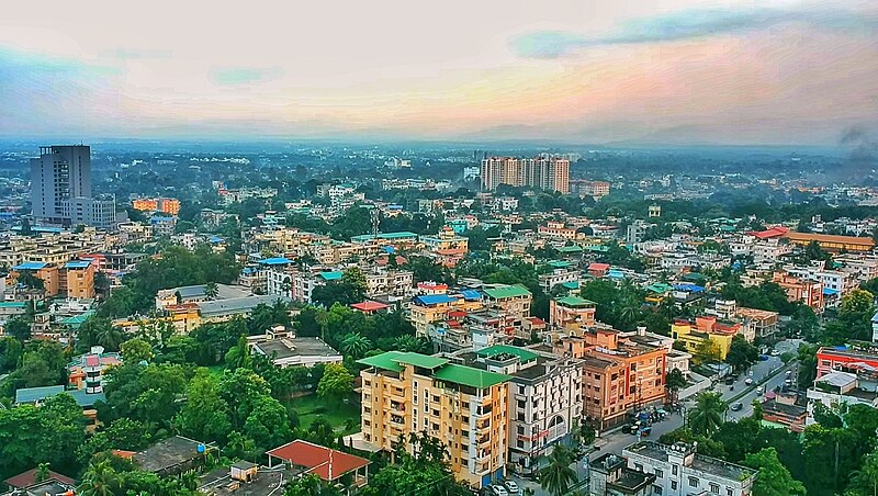
Siliguri (, ; ), also known as Shiliguri, is a major tier-II city in West Bengal. It forms the Twin Cities with the neighbouring city of Jalpaiguri. The city spans areas of the Darjeeling and Jalpaiguri districts in the Indian state of West Bengal. Known as the "Gateway of Northeast India", It is located on the banks of the Mahananda in the foothills of the Himalayas. Siliguri is the third largest urban agglomeration in West Bengal, after Kolkata and Asansol.
Siliguri is a major city in West Bengal, India, located in the foothills of the Himalayas and known as the "Gateway of Northeast India" because of its strategic position. It is the third-largest urban area in West Bengal and forms a twin-city with its neighboring city of Jalpaiguri.
AI-generated from the Wikipedia summary — may contain errors.
Key facts
- Settlement.name
- Siliguri
- Settlement.native_name_lang
- bn
- Settlement.settlement_type
- City
- Settlement.image_caption
- Clockwise from top left: Siliguri aerial view, Science Centre entrance, Ewam India Monastery, Toy Train in Siliguri, Teesta River, Lions Clock Tower, Sevoke Roadway Bridge, Siliguri City Centre, ISKCON Temple, Siliguri traffic
- Settlement.pushpin_map
- India West Bengal#India3
- Settlement.pushpin_map_caption
- Location in West Bengal##Location in India
- Settlement.coordinates
- [1]
- Settlement.subdivision_type
- Country
- Settlement.subdivision_type1
- State
- Settlement.subdivision_type2
- District
- Settlement.subdivision_type3
- No. of Wards
- Settlement.subdivision_name1
- West Bengal
- Settlement.subdivision_name3
- 47
- Settlement.established_date
- 1994
- Settlement.nicknames
- Gateway to the Dooars, Gateway of Northeast India, City of Hospitality
- Settlement.government_type
- Municipal corporation
- Settlement.governing_body
- Siliguri Municipal Corporation
- Settlement.leader_title
- Mayor
via Wikipedia infobox
Official website
Welcome to Siliguri Municipal Corporation, Siliguri, West Bengal
Siliguri Municipal Corporation
siligurismc.in →Link to the official site · 18,697 chars · not written by Vinony
Wikidata facts
- Instance of
- big city
- Country
- India
- Located in
- Siliguri subdivision
- Population
- 218718
- Area
- 41.90
- Elevation
- 400
- Time zone
- UTC+05:30
- Capital of
- Siliguri subdivision
- Official website
- www.siligurismc.in
- Image
- Siliguri view.jpg
- Households
- 49895
- Dialing code
- 353
Show 8 more facts
- Commons category
- Siliguri
- topic's main category
- Category:Siliguri
- postal code
- 734001
- category of associated people
- Category:People from Siliguri
- male population
- 112167
- illiterate population
- 51604
- literate population
- 167114
- female population
- 106551
Sources (9)
via Wikidata · CC0
~33 min read
Encyclopedic overview
37 sectionsContents
- History
- Etymology
- Modern history
- Geography
- Location
- Climate
- Temperature
- Rainfall and other conditions
- Demographics
- Languages
- Religion
- Governance and politics
- Civic administration
- Municipal finance
- Lok Sabha and Vidhan Sabha constituency
- Civic services and infrastructure
- Flora and fauna
- Flora
- Fauna
- Transport
- Roads
- Bus services
- Rail
- Air
- Educational facilities
- University
- Colleges
- Schools
- Media
- Sports facilities
- Kanchenjunga Stadium
- Municipal corporation indoor stadium
- Visitors' attractions
- Notable people
- See also
- References
- External links
Siliguri (, ; ), also known as Shiliguri, is a major tier-II city in West Bengal. It forms the Twin Cities with the neighbouring city of Jalpaiguri. The city spans areas of the Darjeeling and Jalpaiguri districts in the Indian state of West Bengal. Known as the "Gateway of Northeast India", It is located on the banks of the Mahananda in the foothills of the Himalayas. Siliguri is the third largest urban agglomeration in West Bengal, after Kolkata and Asansol.
Siliguri has great strategic importance in West Bengal, with convenient access to three international borders: Nepal, Bangladesh and Bhutan. It also connects the North-East with mainland India. Located in the foothills of Eastern Himalayas, Siliguri is a significant trading and transportation hub.
Excerpted from Wikipedia’s “Siliguri” article, available under the CC BY-SA 4.0 licence.
Gallery (44)
On the map
5 mapped locations