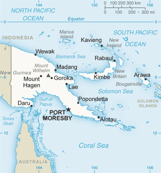
File:Papua_New_Guinea_map.png · Wikimedia Commons · See Wikimedia Commons
Solomon Sea
Sign in to saveInterisland Sea in the Pacific Ocean
AI overview
The Solomon Sea is a body of water in the Pacific Ocean that lies between several islands in the region. It is an important area for maritime activity and serves as a passage connecting different parts of the Pacific.
AI-generated from the Wikipedia summary — may contain errors.
Wikidata facts
- Instance of
- sea
- Part of
- Pacific Ocean
- Country
- Papua New Guinea
- Area
- 720000
- Shares border with
- South Pacific Ocean
- Image
- Kennedy Island, Kasolo Island, Pudding Plum.JPG
Show 6 more facts
- topic's main category
- Category:Solomon Sea
- basin country
- Papua New Guinea
- vertical depth
- 9140
- Commons category
- Solomon Sea
- native label
- Solomon Sea
- on focus list of Wikimedia project
- Wikipedia:Vital articles/Level/4
Sources (3)
via Wikidata · CC0
~3 min read
Encyclopedic overview
The Solomon Sea is a sea located within the Pacific Ocean. It lies between Papua New Guinea and Solomon Islands. Many major battles were fought there during World War II.
Extent
Excerpted from Wikipedia’s “Solomon Sea” article, available under the CC BY-SA 4.0 licence.
On the map
4 mapped locations
Available in 72 languages
- Español
- Français
- Deutsch
- 中文
- 日本語
- Русский
- Português
- Italiano
- العربية
- Afrikaans
- Albanian
- Armenian
- Asturian
- Azerbaijani
- Bahasa Indonesia
- Bangla
- Bashkir
- Basque
Show 53 more
- be_x_old
- Belarusian
- Bosnian
- Bulgarian
- Burmese
- Catalan
- Chuvash
- Croatian
- Czech
- Esperanto
- Estonian
- Fiji Hindi
- Finnish
- Galician
- Georgian
- Greek
- Hebrew
- Hungarian
- Icelandic
- Iloko
- Karachay-Balkar
- Latin
- Latvian
- Lithuanian
- Low German
- Macedonian
- Malay
- Marathi
- Mari
- Mingrelian
- Nederlands
- Norwegian
- Polski
- Punjabi
- Romanian
- Serbian
- Serbian (Latin)
- simple
- Svenska
- Swahili
- Tiếng Việt
- Türkçe
- Ukrainian
- Urdu
- Waray
- Welsh
- Western Frisian
- Wu Chinese
- zh_min_nan
- zh_yue
- فارسی
- ไทย
- 한국어
via Wikidata sitelinks · CC0