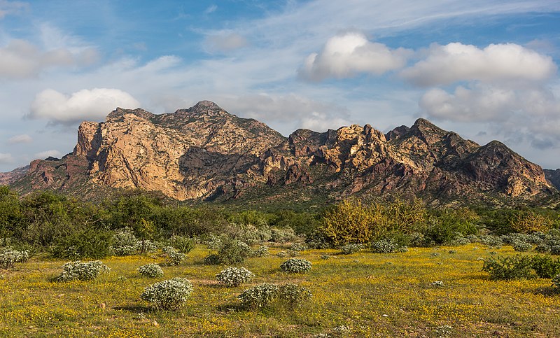
File:San_Carlos_Sonora_landscape.jpg · Wikimedia Commons · See Wikimedia Commons
ایالت سونورا
Sign in to saveAlso known as Estado de Sonora
Sonora (), officially Estado Libre y Soberano de Sonora (), is one of the 31 states which, along with Mexico City, comprise the Federal Entities of Mexico. The state is divided into 72 municipalities; the capital (and largest) city of which is Hermosillo, located in the center of the state. Other large cities include Ciudad Obregón, Nogales (on the Mexico-United States border), San Luis Río Colorado, and Navojoa.
Sonora is a state in Mexico located in the northwestern part of the country, divided into 72 municipalities with its capital in Hermosillo. It matters as one of Mexico's significant states and is notable for including major cities like Nogales, which sits on the U.S.-Mexico border.
AI-generated from the Wikipedia summary — may contain errors.
Key facts
- Settlement.name
- Sonora
- Settlement.settlement_type
- State
- Settlement.image_skyline
- San Carlos Sonora landscape.jpg
- Settlement.image_caption
- View of San Carlos Nuevo Guaymas
- Settlement.image_shield
- Coat of arms of Sonora.svg
- Settlement.shield_link
- Seal of Sonora
- Settlement.shield_size
- 80px
- Settlement.anthem
- Himno del Estatal de Sonora
- Settlement.image_map
- Sonora in Mexico (location map scheme).svg
- Settlement.map_caption
- State of Sonora within Mexico
- Settlement.subdivision_type
- Country
- Settlement.subdivision_name
- Mexico
- Settlement.subdivision_type1
- Capital
- Settlement.subdivision_name1
- Hermosillo
- Settlement.subdivision_type2
- Municipalities
- Settlement.subdivision_name2
- 72
- Settlement.established_title
- Admission
- Settlement.established_date
- January 10, 1824
via Wikipedia infobox
Wikidata facts
- Instance of
- state of Mexico
- Part of
- Northern Mexico
- Official name
- Sonora
- Demonym
- Sonorense
- Country
- Mexico
- Located in
- Mexico
- Contains
- Huatabampo Municipality
- Continent
- North America
- Capital
- Hermosillo
- Population
- 2850330
- Area
- 179503
- Elevation
- 592
- Time zone
- UTC−07:00
- Head of government
- Alfonso Durazo Montaño
- Shares border with
- Baja California
- Official website
- www.sonora.gob.mx
- Image
- Sonora.JPG
Show 10 more facts
- language used
- O'odham
- Commons category
- Sonora
- postal code
- 83-85
- topic's main category
- Category:Sonora
- inception
- 1831-01-01
- Commons gallery
- Sonora
- category of associated people
- Category:People from Sonora
- category for people born here
- Category:Births in Sonora
- described by source
- Encyclopædia Britannica 11th edition
- native label
- Sonora
Sources (10)
via Wikidata · CC0
Gallery (52)
On the map
3 mapped locations
Available in 100 languages
- Español
- Français
- Deutsch
- 中文
- 日本語
- Русский
- Português
- Italiano
- العربية
- Afrikaans
- Aragonese
- Armenian
- Asturian
- Aymara
- Azerbaijani
- Bahasa Indonesia
- Balinese
- Basque
Show 81 more
- Bavarian
- be_x_old
- Belarusian
- Bishnupriya
- Breton
- Bulgarian
- Catalan
- Cebuano
- Central Kurdish
- Chechen
- Cherokee
- Cheyenne
- Cornish
- Croatian
- Czech
- Danish
- Egyptian Arabic
- Esperanto
- Estonian
- Filipino
- Finnish
- Galician
- Georgian
- Greek
- Hebrew
- Hungarian
- Icelandic
- Ido
- Iloko
- Interlingua
- Irish
- Ladino
- Latin
- Latvian
- Lithuanian
- Macedonian
- Malagasy
- Malay
- Marathi
- Mazanderani
- Nederlands
- Northern Frisian
- Norwegian
- Norwegian Nynorsk
- Occitan
- Ossetic
- Pampanga
- Piedmontese
- Polski
- ppl
- Punjabi
- Quechua
- Romanian
- Sardinian
- Scots
- Serbian
- Serbian (Latin)
- simple
- Sinhala
- Slovak
- Svenska
- Swahili
- Tajik
- Tatar
- Tiếng Việt
- Tumbuka
- Türkçe
- Ukrainian
- Urdu
- Uzbek
- Venetian
- Waray
- Welsh
- Western Frisian
- Western Panjabi
- Wu Chinese
- zh_min_nan
- zh_yue
- فارسی
- ไทย
- 한국어
via Wikidata sitelinks · CC0