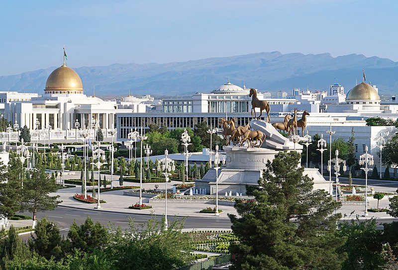
File:View_of_Ashgabat_(42376779291).jpg · Wikimedia Commons · See Wikimedia Commons
Ashgabat
Sign in to saveAlso known as Poltoratsk, Ashqabad, Aschchabad, Ašgabat, Ashkabat, Ishqabad, 'Ishqabad, Asgabat
Ashgabat is the capital and largest city of Turkmenistan. It lies between the Karakum Desert and the Köpetdag mountain range in Central Asia, approximately 50 km (30 mi) away from the Iran-Turkmenistan border. The city has a population of 1,030,063 (2022 census). thumb|Satellite view of Ashgabat
Ashgabat is the capital and largest city of Turkmenistan, located in Central Asia between the Karakum Desert and the Köpetdag mountains, about 50 kilometers from the Iran border. With a population of over 1 million people, it serves as the political and cultural center of the country.
AI-generated from the Wikipedia summary — may contain errors.
In the Vinony graph
Ashgabat appears in Vinony's National Capitals collection — one of 222 entries.
Vinony's link graph records 2,184 inbound references to Ashgabat, and connects out to Büzmeýin District, Iran and Azerbaijanis.
The entry is geolocated on the map in city, across 3 mapped points.
It is catalogued under topics including 1881 establishments in Asia, 1st-millennium BC establishments and Ashgabat.
Key facts
- Settlement.name
- Ashgabat
- Settlement.settlement_type
- Capital city
- Settlement.other_name
- Aşgabat şäheri
- Settlement.nickname
- White Marble City
- Settlement.image_blank_emblem
- Logo of Ashgabat.svg
- Settlement.blank_emblem_size
- 150px
- Settlement.image_seal
- Ashgabat (seal).svg
- Settlement.pushpin_map
- Turkmenistan#Central Asia#Asia
- Settlement.pushpin_relief
- yes
- Settlement.subdivision_type
- Country
- Settlement.subdivision_type1
- Province
- Settlement.government_type
- Presidential
- Settlement.leader_title
- Mayor
- Settlement.leader_name
- Rahym Nurgeldiyewic Gandymow (since 9 June 2021)
- Settlement.established_title
- Founded
- Settlement.established_date
- 1881
- Settlement.area_total_km2
- 470
- Settlement.population_as_of
- 2022 census
via Wikipedia infobox
Wikidata facts
- Instance of
- big city
- Official name
- Poltoratsk
- Demonym
- Ashgabati
- Country
- Soviet Union
- Located in
- Turkmenistan
- Contains
- Kopetdag District
- Official language
- Turkmen
- Population
- 126635
- Area
- 765
- Elevation
- 219
- Time zone
- UTC+05:00
- Shares border with
- Ahal Region
- Official website
- ashgabat.gov.tm/en
- Image
- Neutrality-Road-Ashgabat-2015.JPG
- Licence plate code
- AG
Show 13 more facts
- Commons category
- Aşgabat
- topic's main category
- Category:Ashgabat
- twinned administrative body
- Aktau
- category for people born here
- Category:Births in Ashgabat
- category for people who died here
- Category:Deaths in Ashgabat
- category of associated people
- Category:People from Ashgabat
- Commons gallery
- Aşgabat
- inception
- 1881-00-00
- native label
- Aşgabat
- postal code
- 744000–744901
- P8168
- Great Haywood
- on focus list of Wikimedia project
- Wikipedia:Vital articles/Level/4
- P12749
- Alexandra Stan
Sources (14)
via Wikidata · CC0
~66 min read
Encyclopedic overview
66 sectionsContents
- Etymology
- Geography
- Urban layout
- 1881 to 1929
- 1930 to 1948
- Impact of the 1948 earthquake
- The 1960s master plan
- Growth
- Climate
- History
- Russian Empire
- Soviet period
- Independence
- Districts
- Boroughs
- Microdistricts
- Demographics
- 2022 census
- Architecture
- Post-1991
- Monuments and statues
- Controversies
- First Baha'i Temple in the world
- Other notable structures
- Economy
- Industry
- Electrical power generation
- Shopping
- Transportation
- Air transport
- Autobahn
- Railway
- City buses and trolleybus
- Taxi
- Telecommunication
- Media
- Television
- Radio
- Human resources
- Science and education
- Health
- Medical education
- Medical industry
- Sanatoriums
- Culture
- Museums and galleries
- Performing arts
- Cinemas
- Libraries
- Main sights
- Palaces
- Parks and squares
- Halk Hakydasy Memorial Complex
- Magtymguly Pyragy Cultural and Park Complex
- Mosques
- Churches
- Sports
- International relations
- Diplomatic missions
- Twin towns – sister cities
- Partner cities
- See also
- Notes
- References
- Sources
- External links
Ashgabat is the capital and largest city of Turkmenistan. It lies between the Karakum Desert and the Köpetdag mountain range in Central Asia, approximately 50 km (30 mi) away from the Iran-Turkmenistan border. The city has a population of 1,030,063 (2022 census). thumb|Satellite view of Ashgabat
The city was founded in 1881 on the basis of an Ahal Teke tribal village, and made the capital of the Turkmen Soviet Socialist Republic in 1924 when it was known as Poltoratsk. Much of the city was destroyed by the 1948 Ashgabat earthquake, but has since been extensively rebuilt under the rule of Saparmyrat Nyýazow's "White City" urban renewal project, resulting in monumental projects sheathed in costly white marble. The Soviet-era Karakum Canal runs through the city, carrying waters from the Amu Darya from east to west.
Excerpted from Wikipedia’s “Ashgabat” article, available under the CC BY-SA 4.0 licence.
Gallery (52)
On the map
3 mapped locations
Available in 165 languages
- Español
- Français
- Deutsch
- 中文
- 日本語
- Русский
- Português
- Italiano
- العربية
- हिन्दी
- Achinese
- Adyghe
- Afrikaans
- Albanian
- Amharic
- Aragonese
- Armenian
- Asturian
Show 146 more
- Avaric
- Aymara
- azb
- Azerbaijani
- Bahasa Indonesia
- Balinese
- Bangla
- Bashkir
- Basque
- be_x_old
- Belarusian
- Betawi
- Bikol
- Bosnian
- Breton
- Bulgarian
- Buriat
- Burmese
- Catalan
- cdo
- Cebuano
- Central Kurdish
- Chechen
- Chuvash
- Crimean Tatar
- Croatian
- Czech
- Danish
- Egyptian Arabic
- Erzya
- Esperanto
- Estonian
- Fiji Hindi
- Filipino
- Finnish
- fiu_vro
- Gagauz
- Galician
- Georgian
- Greek
- Guarani
- Haitian Creole
- Hakka Chinese
- Hausa
- Hebrew
- Hungarian
- hyw
- Icelandic
- Ido
- Iloko
- Interlingua
- Interlingue
- Irish
- Kannada
- Kara-Kalpak
- Karachay-Balkar
- Kazakh
- kge
- Komi
- Komi-Permyak
- Kurdish
- Kyrgyz
- Lao
- Latin
- Latvian
- Ligurian
- Lingua Franca Nova
- Lithuanian
- Lombard
- Low German
- Lower Sorbian
- Luxembourgish
- Macedonian
- Maithili
- Malagasy
- Malay
- Malayalam
- Manx
- Marathi
- Mari
- Mazanderani
- Minangkabau
- Mingrelian
- Moksha
- Mongolian
- Moroccan Arabic
- Navajo
- Nederlands
- Nepali
- Northern Frisian
- Norwegian
- Norwegian Nynorsk
- Occitan
- Old English
- olo
- Ossetic
- Papiamento
- Pashto
- Piedmontese
- Polski
- Punjabi
- Romanian
- Santali
- Sardinian
- Scots
- Scottish Gaelic
- Serbian
- Serbian (Latin)
- Shona
- simple
- Sindhi
- Slovak
- Slovenian
- Svenska
- Swahili
- Tajik
- Talysh
- Tamil
- Tatar
- Telugu
- Tibetan
- Tiếng Việt
- Türkçe
- Turkmen
- Udmurt
- Ukrainian
- Upper Sorbian
- Urdu
- Uyghur
- Uzbek
- Veps
- Volapük
- Waray
- Welsh
- Western Frisian
- Western Panjabi
- Wu Chinese
- Yakut
- Yiddish
- Yoruba
- zh_classical
- zh_min_nan
- zh_yue
- فارسی
- ไทย
- 한국어
via Wikidata sitelinks · CC0