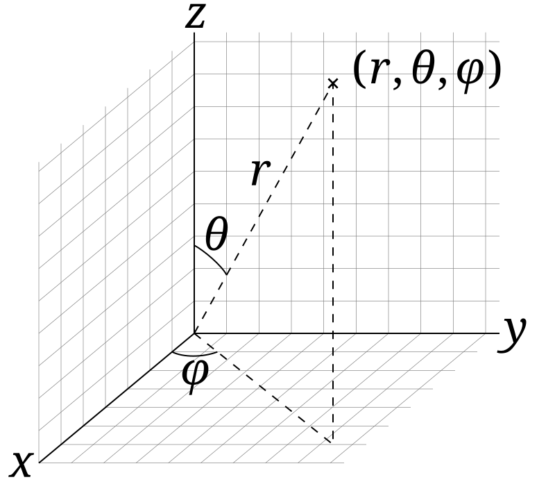
File:3D_Spherical.svg · Wikimedia Commons · See Wikimedia Commons
coordinate system
Sign in to savesystem for determining the position of a point
A coordinate system is a method for pinpointing the exact location of a point using numbers or values. It matters because it allows us to describe positions precisely and consistently, which is essential for everything from navigation and mapmaking to science and engineering.
AI-generated from the Wikipedia summary — may contain errors.
Wikidata facts
- Subclass of
- frame of reference
- Part of
- frame of reference
- Image
- Gauss-féle koordináták.png
- Has parts of class
- coordinate
Show 5 more facts
- topic's main category
- Category:Coordinate systems
- Commons category
- Coordinate systems
- on focus list of Wikimedia project
- Wikipedia:Vital articles/Level/4
- has characteristic
- coordinate origin
- maintained by WikiProject
- WikiProject Mathematics
via Wikidata · CC0
~14 min read
Encyclopedic overview
The spherical coordinate system is commonly used in physics. It assigns three numbers (known as coordinates) to every point in Euclidean space: radial distance r, polar angle θ (theta), and azimuthal angle φ (phi). The symbol ρ (rho) is often used instead of r. In geometry, a coordinate system is a system that uses one or more numbers, or coordinates, to uniquely determine and standardize the position of the points or other geometric elements on a manifold such as Euclidean space. The coordinates are not interchangeable; they are commonly distinguished by their position in an ordered tuple, or by a label, such as in "the x-coordinate". The coordinates are taken to be real numbers in elementary mathematics, but may be complex numbers or elements of a more abstract system such as a commutative ring. The use of a coordinate system allows problems in geometry to be translated into problems about numbers and vice versa; this is the basis of analytic geometry.
Common coordinate systems
Excerpted from Wikipedia’s “coordinate system” article, available under the CC BY-SA 4.0 licence.
Gallery (5)
Available in 95 languages
- Español
- Français
- Deutsch
- 中文
- 日本語
- Русский
- Português
- Italiano
- العربية
- हिन्दी
- abstract
- Afrikaans
- Albanian
- Albanian
- Aragonese
- Armenian
- Assamese
- Asturian
Show 76 more
- Azerbaijani
- Bahasa Indonesia
- Bangla
- Bashkir
- Basque
- be_x_old
- Belarusian
- Bhojpuri
- Bosnian
- Bulgarian
- Burmese
- Catalan
- Central Kurdish
- Chuvash
- Croatian
- Czech
- Danish
- Egyptian Arabic
- Esperanto
- Estonian
- Fiji Hindi
- Filipino
- Finnish
- Galician
- gcr
- Greek
- Haitian Creole
- Hebrew
- Hungarian
- Icelandic
- Ido
- Jamaican Creole English
- Kazakh
- Kyrgyz
- Latin
- Latvian
- Lithuanian
- Low German
- Luxembourgish
- Macedonian
- Malay
- Malayalam
- Nederlands
- Northern Frisian
- Norwegian
- Norwegian Nynorsk
- Occitan
- Oromo
- Polski
- Punjabi
- Romanian
- Scottish Gaelic
- Serbian
- Shona
- Silesian
- simple
- Sindhi
- Slovak
- Slovenian
- Svenska
- Swahili
- Tamil
- Tiếng Việt
- Türkçe
- Ukrainian
- Urdu
- Waray
- Welsh
- Western Panjabi
- Wu Chinese
- Yiddish
- zh_min_nan
- zh_yue
- فارسی
- ไทย
- 한국어
via Wikidata sitelinks · CC0