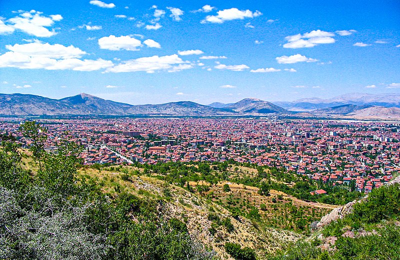
File:DaglardanIsparta.jpg · Wikimedia Commons · See Wikimedia Commons
OverviewAI-generated
Isparta is a city and municipality in Turkey, serving as the capital of Isparta Province. It is located in the Akdeniz Bölgesi region at an elevation of approximately 1,035 meters above sea level. The city operates on Eastern European Time (UTC+03:00) and uses the local dialing code 0246.
With a population of 258,375, Isparta has an urban population of 245,784 and a rural population of 243,020. The postal code for the area is 32000. The city is twinned with Comrat, Genk, and Hamadan.
Synthesized by Vinony from 52 facts across 7 sources: Wikidata, Open Meteo, Openweathermap, OpenStreetMap, GeoNames, Vinony graph, Geo. Generated from structured data (not the Wikipedia text) and checked against those facts — may still contain errors.
Weather now
7-day forecast
via Open-Meteo
Place details
- Locality
- Isparta Merkez
- Region
- Isparta
- Country
- Türkiye
- Population
- 172,334
- Timezone
- Europe/Istanbul
via OpenStreetMap · GeoNames
Key facts
- Turkey place.type
- municipality
- Turkey place.name
- Isparta
- Turkey place.image_skyline
- DaglardanIsparta.jpg
- Turkey place.image_caption
- Isparta seen from a mountain
- Turkey place.image_logo
- Isparta Belediyesi logo.svg
- Turkey place.province
- Isparta
- Turkey place.district
- Isparta
- Turkey place.leader_party
- AK Party
- Turkey place.leader_name
- Şükrü Başdeğirmen
- Turkey place.elevation_m
- 1035
- Turkey place.population_total
- 247580
- Turkey place.population_as_of
- 2022
- Turkey place.postal_code
- 32000
- Turkey place.area_code
- 0246
via Wikipedia infobox
Wikidata facts
- Instance of
- district of Turkey
- Official name
- Isparta
- Country
- Turkey
- Located in
- Isparta Province
- Population
- 247580
- Elevation
- 1035
- Time zone
- UTC+03:00
- Capital of
- Isparta Province
- Official website
- isparta.bel.tr
- Image
- DaglardanIsparta.jpg
- Dialing code
- 0246
Show 13 more facts
- twinned administrative body
- Hamadan
- Commons category
- Isparta
- topic's main category
- Category:Isparta
- postal code
- 32000
- Commons gallery
- Isparta
- category of associated people
- Category:People from Isparta
- social media followers
- 9000
- urban population
- 245784
- rural population
- 21198
- native label
- Isparta
- described by source
- Encyclopædia Britannica 11th edition
- P12749
- August 7
- maintained by WikiProject
- WikiProject Cities
via Wikidata · CC0
Travel guide
Understand
Isparta in antiquity was Baris (Σπάρτη). It stands at an altitude of 1065 m, chilly in winter, but the climate and volcanic soil suits roses. In 1887 many refugees fled here from Bulgaria, especially from Kazanlak, when the decaying Ottoman Empire was yet again trounced in war by expanding Russia. They brought with them the secret of preparing Attar of Rose perfume, and a stock of rose cultivars. This is now the city's main industry: even with the advent of synthetics, this oil remains the basis for rose-scented perfumes, and a valuable byproduct of its extraction is rose water. Petals are harvested at dawn May to June before the sun's warmth opens the buds and releases the oil, a labour-intensive task as 100 kg of petals yields only 25 g of oil. The oil is sold in bulk to the perfume manufacturers with none on sale locally to tourists (and the pure oil is irritant) but there are plenty of rose water products.
The city was badly damaged by an earthquake in 1914. A few mosques were repaired but almost everything else was re-built anew. Isparta is therefore a modern town and doesn't have an old quarter.
Visitor information is available online from the Turkish Tourism Ministry.
Get around
The town sights are all within walking distance. You need your own wheels for outlying sights.
See
thumb | 300px | Near the carpet museum Isparta Museum near the railway station has been "temporarily closed" since about the outbreak of the Trojan Wars. or Grand Mosque is the city's oldest, built in 1429. It was wrecked in the earthquake of 1914 and restored in 1922. Further renovation from 2022 has plonked an underground car park entrance in front of it. Firdevs-Bey Mosque is from 1561. It's 200 m north of Kutlubey Mosque, at Mimar Sinan Cd 24. Cankaya Museum is shown on maps northwest edge of town but is a hoax, it's just a pumpkin patch.
Do
thumb | 300px | Rose oil is the city's main industry Hamams - traditional Turkish baths - are found in a dozen locations. One of the most central is Karaağaç on Firdevs Cd, 500 m south of the railway station, open daily 09:00-01:00. Football: Isparta 32 SK play soccer in TFF 2 Lig, the third tier. Their home ground Atatürk Stadium (capacity 4300) is 500 m southwest of the railway station. The town's other club Ispartaspor folded in 2014.
Buy
Lots of small supermarkets, Bim is the main chain, mostly open daily 09:00-21:00.
Eat
Most eating places are north of the centre, in the streets near Barida Hotels. The old bus station stood here so it's a question how many will survive now that clientele has gone. A smaller group is southwest of the railway station at the foot of Istasyon Cd.
Drink
Near the intersection of Atatürk Cd and Istasyon Cd are Barcelona, Huni Cafe Bar and Beygir Pub.
Sleep
thumb | 300px | Eğirdir Castle
Connect
Isparta and its approach roads have 4G from all Turkish carriers. As of Nov 2024, 5G has not rolled out in Turkey.
Go next
Akşehir is best known as the home of Nasruddin Hoca. Burdur has a good museum. Konya, origin of the "dancing dervishes", has fine Seljuk architecture. Antalya is a large lively beach resort.
Travel guide from Wikivoyage (CC BY-SA 4.0)
Gallery (16)
On the map
3 mapped locations
Available in 69 languages
- Español
- Français
- Deutsch
- 中文
- 日本語
- Русский
- Português
- Italiano
- العربية
- Armenian
- Asturian
- azb
- Azerbaijani
- Bahasa Indonesia
- Basque
- be_x_old
- Belarusian
- Breton
Show 50 more
- Bulgarian
- Catalan
- Cebuano
- Chechen
- Czech
- Danish
- Egyptian Arabic
- Esperanto
- Georgian
- Gilaki
- Greek
- Hebrew
- Hungarian
- Kazakh
- Kinyarwanda
- Latvian
- Lithuanian
- Malay
- Mazanderani
- Minangkabau
- Nederlands
- Norwegian
- Norwegian Nynorsk
- Ossetic
- Polski
- Romanian
- Scots
- Serbian
- Serbian (Latin)
- simple
- Slovak
- Svenska
- Swahili
- Tajik
- Talysh
- Tatar
- Tiếng Việt
- Türkçe
- Turkmen
- Udmurt
- Ukrainian
- Urdu
- Waray
- Western Mari
- Western Panjabi
- Wu Chinese
- Zaza
- zh_min_nan
- فارسی
- 한국어
via Wikidata sitelinks · CC0