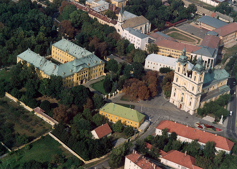
File:Kalocsa_-_Archiepiscopal_palace.jpg · Wikimedia Commons · See Wikimedia Commons
Kalocsa
Sign in to saveKalocsa (; or Kalača; or Калоча; ) is a town in Bács-Kiskun county, Hungary. It lies south of Budapest. It is situated in a marshy but highly productive district, near the left bank of the Danube River. Historically it had greater political and economic importance than at present.
Key facts
- Settlement <! more fields are available for this Infobox See Template:Infobox Settlement >.official_name
- Kalocsa
- Settlement <! more fields are available for this Infobox See Template:Infobox Settlement >.settlement_type
- Town
- Settlement <! more fields are available for this Infobox See Template:Infobox Settlement >.image_skyline
- Kalocsa - Archiepiscopal palace.jpg
- Settlement <! more fields are available for this Infobox See Template:Infobox Settlement >.image_caption
- Archepiscopal Palace
- Settlement <! more fields are available for this Infobox See Template:Infobox Settlement >.image_shield
- Coa Hungary Town Kalocsa.svg
- Settlement <! more fields are available for this Infobox See Template:Infobox Settlement >.image_flag
- Flag of Kalocsa.svg
- Settlement <! more fields are available for this Infobox See Template:Infobox Settlement >.pushpin_map
- Hungary Bács-Kiskun#Hungary
- Settlement <! more fields are available for this Infobox See Template:Infobox Settlement >.pushpin_map_caption
- Location of Kalocsa
- Settlement <! more fields are available for this Infobox See Template:Infobox Settlement >.subdivision_type
- Country
- Settlement <! more fields are available for this Infobox See Template:Infobox Settlement >.subdivision_type1
- County
- Settlement <! more fields are available for this Infobox See Template:Infobox Settlement >.subdivision_name1
- Bács-Kiskun
- Settlement <! more fields are available for this Infobox See Template:Infobox Settlement >.subdivision_type2
- District
- Settlement <! more fields are available for this Infobox See Template:Infobox Settlement >.subdivision_name2
- Kalocsa
- Settlement <! more fields are available for this Infobox See Template:Infobox Settlement >.area_total_km2
- 53.18
- Settlement <! more fields are available for this Infobox See Template:Infobox Settlement >.population_total
- 16136
- Settlement <! more fields are available for this Infobox See Template:Infobox Settlement >.population_as_of
- 2015
- Settlement <! more fields are available for this Infobox See Template:Infobox Settlement >.population_density_km2
- 326.42
- Settlement <! more fields are available for this Infobox See Template:Infobox Settlement >.postal_code_type
- Postal code
via Wikipedia infobox
Wikidata facts
- Country
- Hungary
- Located in
- Kalocsa District
- Population
- 14257
- Area
- 53.18
- Time zone
- UTC+02:00
- Official website
- www.kalocsa.hu
- Image
- Kalocsa Szentháromság tér.JPG
- Dialing code
- 78
Show 7 more facts
- Commons category
- Kalocsa
- topic's main category
- Category:Kalocsa
- postal code
- 6300
- P6482
- Kalocsa
- P8168
- Al Dhafra Club
- described by source
- Encyclopædia Britannica 11th edition
- twinned administrative body
- Polyarnye Zori
via Wikidata · CC0
~21 min read
Encyclopedic overview
10 sectionsContents
- Description
- History
- Main sights
- The Archbishop's Palace
- Notable people
- Sport
- Twin towns – sister cities
- See also
- References
- External links
Kalocsa (; or Kalača; or Калоча; ) is a town in Bács-Kiskun county, Hungary. It lies south of Budapest. It is situated in a marshy but highly productive district, near the left bank of the Danube River. Historically it had greater political and economic importance than at present.
==Description== Kalocsa is the Episcopal see of one of the four Catholic archbishops of Hungary. Amongst its buildings are a fine cathedral, the archiepiscopal palace, an astronomical observatory, a seminary for priests, and colleges for training teachers. The residents of Kalocsa and its wide-spreading communal lands are chiefly employed in the cultivation of paprika, fruit, flax, hemp and cereals, in the capture of waterfowl and in fishing.
Excerpted from Wikipedia’s “Kalocsa” article, available under the CC BY-SA 4.0 licence.
Gallery (11)
On the map
2 mapped locations