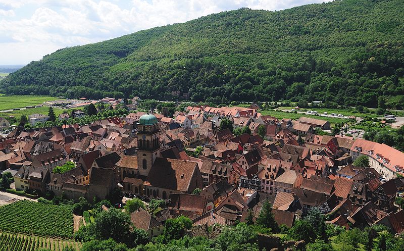
File:Kaysersberg.jpg · Wikimedia Commons · See Wikimedia Commons
Kaysersberg
Sign in to saveAlso known as Mont-Libre
Kaysersberg (; ; ) is a historical town and former commune in Alsace in northeastern France. The name is German for ''Emperor's Mountain''. The high fortress that dominates the town serves as a reminder of both its strategic importance and its warlike past.
OverviewAI-generated
Kaysersberg is a former commune in France, located within the Grand Est region. It served as the capital of the canton of Kaysersberg and was situated in the arrondissement of Ribeauvillé. The area covered 24.82 square kilometers and shared borders with Ammerschwihr, Labaroche, Lapoutroie, and Fréland. Its official name was Kaysersberg, Mont-Libre, and it held membership in the Décapole.
The population of the commune was recorded as 4,696, with an elevation above sea level of 924 meters. It utilized the postal code 68240 and fell under the Europe/Paris timezone. Kaysersberg was dissolved on December 31, 2015, and was subsequently replaced by Kaysersberg Vignoble.
Synthesized by Vinony from 49 facts across 7 sources: Wikidata, Open Meteo, Openweathermap, OpenStreetMap, GeoNames, Vinony graph, Geo. Generated from structured data (not the Wikipedia text) and checked against those facts — may still contain errors.
Weather now
7-day forecast
via Open-Meteo
Place details
- Locality
- Kaysersberg-Vignoble
- Region
- Grand Est
- Country
- France
- Population
- 2,815
- Timezone
- Europe/Paris
via OpenStreetMap · GeoNames
Key facts
- French commune.name
- Kaysersberg
- French commune.image
- Kaysersberg.jpg
- French commune.native name
- (Alsatian)
- French commune.caption
- The town as seen from the castle
- French commune.image coat of arms
- Blason de la ville de Kaysersberg (68).svg
- French commune.arrondissement
- Colmar-Ribeauvillé
- French commune.canton
- Sainte-Marie-aux-Mines
- French commune.INSEE
- 68162
- French commune.postal code
- 68240
- French commune.type
- Delegated commune
- French commune.commune
- Kaysersberg Vignoble
- French commune.elevation m
- 240
- French commune.elevation min m
- 236
- French commune.elevation max m
- 924
- French commune.area km2
- 24.82
- French commune.population
- 2720
- French commune.population date
- 2022
via Wikipedia infobox
Wikidata facts
- Instance of
- commune of France
- Official name
- Mont-Libre
- Country
- France
- Located in
- arrondissement of Colmar-Ribeauvillé
- Population
- 2450
- Area
- 24.82
- Elevation
- 455
- Time zone
- UTC+01:00
- Capital of
- canton of Kaysersberg
- Shares border with
- Mittelwihr
- Official website
- www.cc-kaysersberg.fr
- Image
- 00 0389 Gebäude in Kaysersberg - Elsass.jpg
Show 8 more facts
- Commons category
- Kaysersberg
- Commons gallery
- Kaysersberg
- replaced by
- Kaysersberg Vignoble
- dissolved, abolished or demolished date
- 2015-12-31
- postal code
- 68240
- associated electoral district
- canton of Sainte-Marie-aux-Mines
- P8168
- Kirsty Bertarelli
- member of
- Décapole
Sources (7)
via Wikidata · CC0
Travel guide
See
thumb|Albert Schweitzer Museum
Do
Walking and cycling routes connect Kaysersberg with surrounding vineyards and forest trails in the Vosges foothills, making the town a convenient starting point for short excursions along the Alsace Wine Route.
Drink
Tokay is the specialty wine of Kaysersberg and the town is surrounded by vines. It is now sold as Pinot Gris, after Hungarian Tokaji became a protected denomination of origin. There is a large old stone well in the town which has an inscription advising you to drink wine with dinner and eschew water.
Sleep
Kaysersberg offers a range of accommodation options including small hotels, guesthouses and self-catering holiday apartments in traditional Alsatian buildings. Many places are located within walking distance of the historic centre and vineyards. Availability can be limited during the Christmas market season, so advance booking is recommended.
Travel guide from Wikivoyage (CC BY-SA 4.0)
~4 min read
Encyclopedic overview
11 sectionsContents
- Geography
- Population
- Economy
- Culture
- Folklore
- Tourism
- Notable people
- Gallery
- See also
- References
- External links
Kaysersberg (; ; ) is a historical town and former commune in Alsace in northeastern France. The name is German for ''Emperor's Mountain. The high fortress that dominates the town serves as a reminder of both its strategic importance and its warlike past.
Kaysersberg lies in the canton of Sainte-Marie-aux-Mines, which itself is a subdivision of the Colmar-Ribeauvillé arrondissement. It was a separate commune until 1 January 2016, when it was merged into the new commune of Kaysersberg Vignoble together with nearby Kientzheim and Sigolsheim, and remains its seat.
Excerpted from Wikipedia’s “Kaysersberg” article, available under the CC BY-SA 4.0 licence.
Gallery (13)
On the map
2 mapped locations