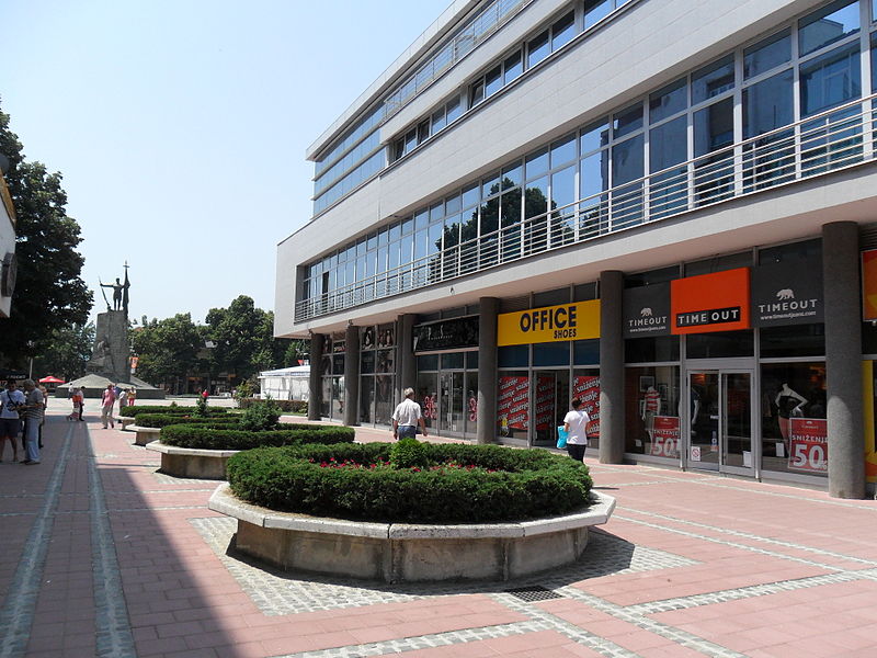
File:KV2011.JPG · Wikimedia Commons · See Wikimedia Commons
Kraljevo
Sign in to saveI don't have any context provided to create an overview of Kraljevo. Could you please provide the background information or source material about Kraljevo that you'd like me to base the overview on?
AI-generated from the Wikipedia summary — may contain errors.
Key facts
- Settlement.name
- Kraljevo
- Settlement.native_name_lang
- sr
- Settlement.official_name
- City of Kraljevo
- Settlement.settlement_type
- City
- Settlement.image_shield
- Kraljevo-grb.png
- Settlement.image_flag
- Zastava Grada Kraljeva.svg
- Settlement.image_map
- Municipalities of Serbia Kraljevo.png
- Settlement.map_caption
- Location of the city of Kraljevo within Serbia
- Settlement.subdivision_type
- Country
- Settlement.subdivision_type1
- Region
- Settlement.subdivision_name1
- Šumadija and Western Serbia
- Settlement.subdivision_type2
- District
- Settlement.subdivision_name2
- Raška
- Settlement.parts_type
- Settlements
- Settlement.parts_style
- para
- Settlement.p1
- 92
- Settlement.leader_party
- SNS
- Settlement.leader_title
- Mayor
via Wikipedia infobox
Wikidata facts
- Country
- Yugoslavia
- Located in
- Kraljevo City
- Population
- 66688
- Area
- 1530
- Elevation
- 207
- Time zone
- UTC+01:00
- Official website
- www.kraljevo.rs
- Image
- Spomenik na centralnom gradskom trgu u Kraljevu.JPG
- Dialing code
- 036
- Licence plate code
- KV
Show 8 more facts
- Commons category
- Kraljevo
- topic's main category
- Category:Kraljevo
- twinned administrative body
- Kotor Varoš
- category for people born here
- Category:Births in Kraljevo
- category of associated people
- Category:People from Kraljevo
- postal code
- 36000
- maintained by WikiProject
- WikiProject Serbia
- native label
- Kraljevo
Sources (7)
via Wikidata · CC0
~13 min read
Encyclopedic overview
17 sectionsContents
- Name
- History and sights
- 2010 earthquake
- Demographics
- Ethnic groups
- Settlements
- Economy
- Tourism
- Sport
- Climate
- Famous residents
- Twin towns – sister cities
- Gallery
- See also
- References
- Further reading
- External links
Kraljevo (, ) is a city and the administrative center of the Raška District in central Serbia. It is situated on the confluence of West Morava and Ibar, in the geographical region of Šumadija, between the mountains of Kotlenik in the north, and Stolovi in the south.
In 2022, the city urban area has a population of 57,432 inhabitants, while the city administrative area has 110,196 inhabitants. With an area of 1530 km2, it is the largest municipality (after Belgrade) in Serbia by area.
Excerpted from Wikipedia’s “Kraljevo” article, available under the CC BY-SA 4.0 licence.
Gallery (18)
On the map
3 mapped locations
Available in 62 languages
- Español
- Français
- Deutsch
- 中文
- 日本語
- Русский
- Português
- Italiano
- العربية
- Albanian
- Armenian
- Azerbaijani
- Bahasa Indonesia
- be_x_old
- Bosnian
- Bulgarian
- Catalan
- Cebuano
Show 43 more
- Central Kurdish
- Chechen
- Croatian
- Czech
- Danish
- Egyptian Arabic
- Esperanto
- Estonian
- Finnish
- Georgian
- Greek
- Hebrew
- Hungarian
- Javanese
- Latvian
- Lithuanian
- Lombard
- Macedonian
- Malay
- Mongolian
- Nederlands
- Norwegian
- Norwegian Nynorsk
- Ossetic
- Pashto
- Polski
- Romanian
- Serbian
- Serbian (Latin)
- Silesian
- Slovak
- Slovenian
- Southern Sotho
- Svenska
- Tatar
- Tiếng Việt
- Türkçe
- Ukrainian
- Urdu
- Waray
- Western Panjabi
- فارسی
- 한국어
via Wikidata sitelinks · CC0