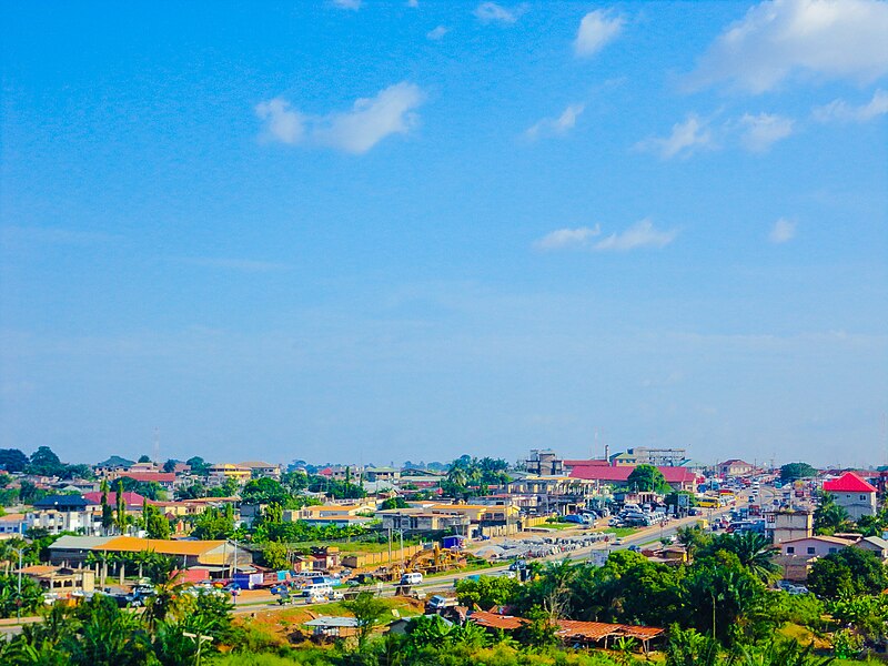
File:Kronum_Kumasi_2018-11-08_(130246).jpg · Wikimedia Commons · See Wikimedia Commons
Kumasi
Sign in to saveAlso known as Coomassie, Kumase, Comassie
Kumasi is a city and the capital of the Kumasi Metropolitan Assembly and the Ashanti Region of Ghana. It is the second largest city in the country, with a population of 443,981 as of the 2021 census. Kumasi is located in a rain forest region near Lake Bosomtwe and is located about from Accra. The city experiences a tropical savanna climate, with two rainy seasons which range from minor to major. Major ethnic groups who live in Kumasi are the Asante, Dagombas, Mole-Dagbon and Ewe. As of 2025, the mayor of the metropolitan is Ofori-Agyeman Boadi.
OverviewAI-generated
Kumasi is a city and metropolitan area in Ghana, serving as the capital of the Ashanti Region. Established in 1680, it is located within the Kumasi Metropolitan District and covers an area of 254 square kilometers. The city’s official languages are English and Twi, and it has a population of 3,903,480. Its elevation is approximately 300 meters above sea level, and it operates under the Africa/Accra timezone.
The administrative territory includes the Ejisu-Juaben Municipal District, Adansi North District, Adansi South District, and Afigya Kwabre District. Kumasi is twinned with Abidjan, Treichville, Atlanta, and Almere. Notable features within the city include the Kumasi Zoological Gardens, situated on Kejetia Road in the Mbrom area. The local dialing code is 032, and postal codes range from AK000 to AK911.
Synthesized by Vinony from 51 facts across 7 sources: Wikidata, Open Meteo, Openweathermap, OpenStreetMap, GeoNames, Vinony graph, Geo. Generated from structured data (not the Wikipedia text) and checked against those facts — may still contain errors.
Weather now
7-day forecast
via Open-Meteo
Place details
- Locality
- Kumasi
- Region
- Ashanti Region
- Country
- Ghana
- Population
- 2,544,530
- Timezone
- Africa/Accra
via OpenStreetMap · GeoNames
Key facts
- Settlement.name
- Kumasi
- Settlement.settlement_type
- City
- Settlement.image_caption
- Top to bottom; left to right: Kronom suburb in Kumasi, Prempeh I International Airport, Manhyia Palace, Armed Forces Museum
- Settlement.seal_size
- 50px
- Settlement.seal_link
- Seal (emblem)
- Settlement.map_caption
- Location of Kumasi in Ashanti, Central Ghana
- Settlement.etymology
- Twi: Kumase ("under the kum tree")
- Settlement.nicknames
- The Garden City, Oseikrom
- Settlement.image_flag
- Flag of the City of Kumasi.svg
- Settlement.pushpin_map
- Ashanti#Ghana#Africa
- Settlement.pushpin_label_position
- bottom
- Settlement.subdivision_type
- Country
- Settlement.subdivision_type1
- Region
- Settlement.subdivision_type2
- District
- Settlement.subdivision_name2
- Kumasi Metropolitan
- Settlement.subdivision_type3
- Historic countries
- Settlement.subdivision_name3
- Ashanti Empire
- Settlement.established_title
- Founded
via Wikipedia infobox
Wikidata facts
- Instance of
- human settlement
- Country
- Ghana
- Located in
- Kumasi Metropolitan District
- Contains
- Sekyere East District
- Continent
- Africa
- Official language
- Twi
- Population
- 3903480
- Area
- 254
- Elevation
- 300
- Time zone
- UTC±00:00
- Legislature
- Kumasi Metropolitan District
- Capital of
- Ashanti Region
- Location
- Ashanti Region
- Official website
- www.kma.gov.gh
- Image
- Virginia Palmer, Ambassador of the United States to Ghana, made her first visit to Kumasi to meet local leaders from September 29 to 30, 2022 - 5.jpg
- Dialing code
- 032
Show 10 more facts
- Commons category
- Kumasi
- has seal, badge, or sigil
- seal
- topic's main category
- Category:Kumasi
- twinned administrative body
- Ouagadou
- category for people born here
- Q8060237
- category of associated people
- Category:People from Kumasi
- inception
- 1680-00-00
- postal code
- AK000-AK911
- P8168
- Carl von Donop
- P12749
- September 10
Sources (7)
via Wikidata · CC0
Travel guide
Understand
Kumasi was established by the King Osei Tutu I with guidance from the priest Okomfo Anokye. The city is the home of the Ashanti King, Otumfuo Osei Tutu II (as of 2023), to whom Ashantis from all walks of life pay homage. The king presides over the traditional courts that some residents use instead of the official judicial system.
Prior to the British colonisation, Kumasi was the capital of the Ashanti Empire, one of the great civilisations of Africa. Once one of the most impressive pre-colonial cities in Africa, it was largely destroyed by the British in a series of wars at the end of the 19th century. Little remains of its former glory.
The urban area has a population of over 3.4 million (2021). The local language is predominantly Akan Twi.
Get in
Kumasi is a cosmopolitan city with a good road network and one can travel on local buses which ply predetermined routes or charter/hire taxis to take one to his preferred destination.
Get around
The tro-tro station in the city centre offers the widest range of destinations. The disadvantage of this tro-tro station is that it is extremely chaotic and that it is right in the city centre: getting out of the city is often problematic due to a plethora of traffic jams. If you can't find your tro-tro, ask one of the tro-tro mates or one of the ticket sellers. The destinations are posted on signs above the bus station.
Another alternative is to catch a tro-tro from the ring road instead. This saves you the hassle of navigating through the Kumasi traffic jams.
See
thumb|250px|right|Ghana Armed Forces Museum
Do
A tour of the Palace grounds explains the history of the Ashanti people and the significance of the Ashanti cultural history. thumb|308x308px|Shores of Lake Bosumtwi
Buy
Kente fabric strips, glass beads, Ashanti sandals, batik – pretty much everything under the sun at the Kejetia Market.
Eat
The Noble House Hotel serves excellent Indian and Chinese food. Prices are higher than the average Ghanaian restaurant: expect to pay GH₵30–40 for a curry, some rice and a drink. Noble House has the same owners as the Heritage Restaurant in Osu, Accra. Other options with local cuisine include: African Pot and Grill and Mukyia Delight Cafe & Restaurant.
For an unforgettable dinner, try Maame Serwaa Chop Bar. They serve fufu with fish soup and you eat it with yours hands. Of course only Ghanaians eat here. You eat alfresco in a quiet road.
Drink
Vic Baboo's (Prempeh II Rd) is not the most atmospheric place in town, but it had an impressive cocktail menu. It is a place to meet backpackers, expats and volunteers. The menu features a variety of different Indian, Chinese, Continental, and fast food dishes. The lassi and milkshakes are especially good, staff are friendly and it has a homely atmosphere.
Stay safe
There are safe guides in hotels. Be mindful of pickpockets at the Kejetia Market.
Travel guide from Wikivoyage (CC BY-SA 4.0)
~26 min read
Encyclopedic overview
50 sectionsContents
- History
- Etymology
- Early settlement
- Ashanti Empire
- Colonial era
- Present era
- Geography
- Metropolitan area
- Environmental issues
- Climate
- Cityscape
- Urban planning
- Housing
- Government
- Sub-Metros
- Demographics
- Culture
- Media
- Film
- Virtual stations
- Economy
- Manufacturing
- Energy
- Commerce
- Street hawking
- Infrastructure
- Education
- History
- Secondary education
- Tertiary institutions
- Sports
- Healthcare
- Places of worship
- Recreational parks and gardens
- Transportation
- Air
- Road
- Interchanges
- Bus and taxicab
- Rail
- Port
- International relations
- Twin towns – sister cities
- Notable people
- See also
- Explanatory notes
- References
- Bibliography
- Further reading
- External links
Kumasi is a city and the capital of the Kumasi Metropolitan Assembly and the Ashanti Region of Ghana. It is the second largest city in the country, with a population of 443,981 as of the 2021 census. Kumasi is located in a rain forest region near Lake Bosomtwe and is located about from Accra. The city experiences a tropical savanna climate, with two rainy seasons which range from minor to major. Major ethnic groups who live in Kumasi are the Asante, Dagombas, Mole-Dagbon and Ewe. As of 2025, the mayor of the metropolitan is Ofori-Agyeman Boadi.
The city was the capital of the Asante Empire, which at its peak covered large parts of present-day Ghana and the Ivory Coast. After being taken over by the British in 1896 coupled with experiencing a fast population growth, Kumasi rapidly grew with improvements to its infrastructure, such as roads and the addition of railways. After Ghana gained its independence in 1957, the city became the capital of the Ashanti Region. Kumasi remains the seat of the Asantehene. The city is often regarded as "The Garden City" after Maxwell Fry published his 1945 "Garden City of West Africa" plan for the city. Additionally, it is also due to the abundance of gardens and forestry in the city.
Excerpted from Wikipedia’s “Kumasi” article, available under the CC BY-SA 4.0 licence.
Gallery (42)
On the map
3 mapped locations
Available in 87 languages
- Español
- Français
- Deutsch
- 中文
- 日本語
- Русский
- Português
- Italiano
- العربية
- हिन्दी
- Afrikaans
- Akan
- Armenian
- Asturian
- azb
- Azerbaijani
- Bahasa Indonesia
- Basque
Show 68 more
- Belarusian
- Breton
- Bulgarian
- Catalan
- Cebuano
- Croatian
- Czech
- dag
- Danish
- dga
- Egyptian Arabic
- Esperanto
- Estonian
- Finnish
- Fula
- Galician
- Georgian
- gpe
- Greek
- Guarani
- Hausa
- Hebrew
- Hungarian
- hyw
- Ido
- Irish
- kai
- Kanuri
- Kikuyu
- Kinyarwanda
- kus
- Kyrgyz
- Latvian
- Lithuanian
- Luxembourgish
- Malay
- Moksha
- Mongolian
- Mossi
- N’Ko
- Nederlands
- Northern Frisian
- Norwegian
- Norwegian Nynorsk
- Ossetic
- Polski
- Punjabi
- Romanian
- Serbian
- Serbian (Latin)
- Silesian
- Svenska
- Swahili
- Tiếng Việt
- Türkçe
- Tyap
- Ukrainian
- Urdu
- Uzbek
- Veps
- Volapük
- Waray
- Western Frisian
- Wu Chinese
- Yoruba
- فارسی
- ไทย
- 한국어
via Wikidata sitelinks · CC0