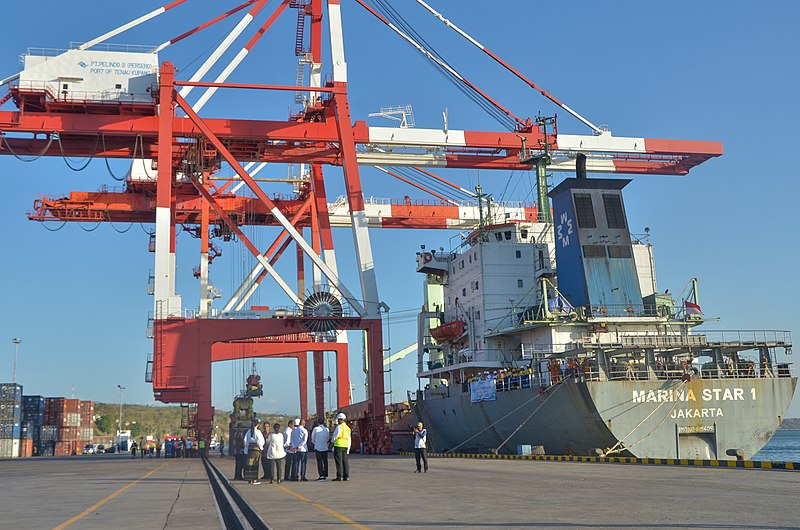
File:Tenau_Port_Kupang.jpg · Wikimedia Commons · See Wikimedia Commons
Kupang
Sign in to saveAlso known as Kota Kupang, Kupang City
Kupang (, ), formerly known as Koepang, is the capital of the Indonesian province of East Nusa Tenggara. At the 2020 Census, it had a population of 442,758; the official estimate as of mid-2024 was 474,801 (comprising 238,997 males and 235,804 females). It is the largest city and port (actually the only independent city in the province) on the island of Timor, and is a part of the Timor Leste–Indonesia–Australia Growth Triangle free trade zone. Geographically, Kupang is the southernmost large city in Indonesia, as well as the closest to Australia.
Kupang is the capital and largest city of Indonesia's East Nusa Tenggara province, located on the island of Timor with a population of nearly 475,000 people as of 2024. It serves as the province's main port and holds strategic importance as Indonesia's southernmost major city, positioned near Australia and part of a regional free trade zone involving Timor Leste, Indonesia, and Australia.
AI-generated from the Wikipedia summary — may contain errors.
Key facts
- Settlement.name
- Kupang
- Settlement.official_name
- City of Kupang''''
- Settlement.settlement_type
- City
- Settlement.motto
- (Build me with a sincere heart)
- Settlement.image_flag
- Flag of Kupang City.png
- Settlement.image_shield
- Lambang Kota Kupang.jpg
- Settlement.image_caption
- Clockwise, from above; Sasando Building, Kupang seen from above, and Kupang lighthouse
- Settlement.pushpin_map
- Timor#Indonesia_Lesser Sunda Islands#Indonesia
- Settlement.pushpin_map_caption
- Location in Timor##Location in Lesser Sunda Islands##Location in Indonesia
- Settlement.subdivision_type
- Country
- Settlement.subdivision_type1
- Province
- Settlement.leader_title
- Mayor
- Settlement.leader_name
- Christian Widodo (PSI)
- Settlement.leader_title1
- Vice Mayor
- Settlement.leader_name1
- Serena Cosgrova Franscies
- Settlement.leader_title2
- Legislature
- Settlement.leader_name2
- Kupang City Regional House of Representatives (DPRD)
- Settlement.established_title
- Founded
via Wikipedia infobox
Wikidata facts
- Official name
- Kota Kupang
- Country
- Indonesia
- Located in
- East Nusa Tenggara
- Contains
- Oebobo
- Population
- 466632
- Area
- 180.27
- Elevation
- 62
- Capital of
- East Nusa Tenggara
- Shares border with
- Kupang
- Official website
- www.kupangkota.go.id
- Image
- Kupang lighthouse and anchorage.JPG
- Licence plate code
- DH
Show 7 more facts
- topic's main category
- Category:Kupang
- Commons category
- Kupang (city)
- postal code
- 85361
- inception
- 1996-04-11
- Statistics Indonesia area code
- 5371
- name
- Kupang
- separated from
- Kupang
via Wikidata · CC0
~18 min read
Encyclopedic overview
20 sectionsContents
- History
- Early history and Portuguese domination
- Dutch colony
- Recent history and independence
- Geography
- Climate
- Demographics
- Economy
- Governance
- Administrative division
- Local government
- Politics
- Infrastructure
- Health
- Education
- Place of worship
- Transportation
- See also
- References
- External links
Kupang (, ), formerly known as Koepang, is the capital of the Indonesian province of East Nusa Tenggara. At the 2020 Census, it had a population of 442,758; the official estimate as of mid-2024 was 474,801 (comprising 238,997 males and 235,804 females). It is the largest city and port (actually the only independent city in the province) on the island of Timor, and is a part of the Timor Leste–Indonesia–Australia Growth Triangle free trade zone. Geographically, Kupang is the southernmost large city in Indonesia, as well as the closest to Australia.
== History == thumbnail|left|The harbor of Kupang in the early 20th century. thumbnail|left|The house of the Resident of Timor in the early 20th century.
Excerpted from Wikipedia’s “Kupang” article, available under the CC BY-SA 4.0 licence.
Gallery (23)
On the map
3 mapped locations
Available in 72 languages
- Español
- Français
- Deutsch
- 中文
- 日本語
- Русский
- Português
- Italiano
- العربية
- Achinese
- Afrikaans
- azb
- Azerbaijani
- Bahasa Indonesia
- Balinese
- Banjar
- Basque
- Batak Toba
Show 53 more
- Belarusian
- Betawi
- Bosnian
- Bulgarian
- Burmese
- Catalan
- Cebuano
- Croatian
- Czech
- Danish
- Esperanto
- Filipino
- Finnish
- Galician
- Georgian
- Gorontalo
- Greek
- Javanese
- kge
- Latin
- Latvian
- Lithuanian
- Macedonian
- Malagasy
- Malay
- Malayalam
- map_bms
- Minangkabau
- Mingrelian
- Nederlands
- Norwegian
- Polski
- Romanian
- Scots
- Serbian
- Serbian (Latin)
- simple
- Svenska
- Tatar
- Tetum
- Tiếng Việt
- Türkçe
- Ukrainian
- Urdu
- Uzbek
- Waray
- Western Panjabi
- Wu Chinese
- zh_min_nan
- zh_yue
- فارسی
- ไทย
- 한국어
via Wikidata sitelinks · CC0