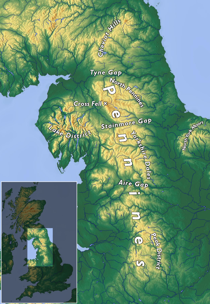
File:Topo_Map_Pennines.png · Wikimedia Commons · See Wikimedia Commons
Pennines
Sign in to saveAlso known as Pennine Chain
The Pennines (), also known as the Pennine Chain or Pennine Hills, are an upland range mainly located in Northern England. Sometimes described as the "backbone of England" because of its length and position, the range runs from Derbyshire and Staffordshire in the north of the Midlands to Northumberland in North East England. From the Tyne Gap in the north, the range extends south through the North Pennines, Yorkshire Dales, South Pennines, and Peak District to end near the valley of the River Trent. The Border Moors and Cheviot Hills, which lie beyond the Tyne Gap, are included in some definit
The Pennines are an upland mountain range stretching across Northern England from the Midlands to the northeast, often called the "backbone of England" due to their length and central position. They form a significant geographical feature that runs through several regions including the Yorkshire Dales and Peak District, influencing the landscape and geography of much of Northern England.
AI-generated from the Wikipedia summary — may contain errors.
Key facts
- Mountain.fetchwikidata
- NONE
- Mountain.name
- Pennines
- Mountain.country
- England, United Kingdom
- Mountain.highest
- Cross Fell
- Mountain.elevation
- 893 m (2,930 ft)
- Mountain.photo
- Topo_Map_Pennines.png
- Mountain.photo_caption
- Northern England and adjoining areas, showing the general extent of the Pennines
- Mountain.location
- Northumberland, Cumbria, County Durham, North Yorkshire, West Yorkshire, South Yorkshire, Lancashire, Greater Manchester, Cheshire, Derbyshire, Staffordshire
via Wikipedia infobox
Wikidata facts
- Instance of
- mountain range
- Country
- United Kingdom
- Located in
- England
- Elevation
- 893
- Highest point
- Cross Fell
- Image
- Pennine scenery.jpg
Show 6 more facts
- topic's main category
- Category:Pennines
- Commons category
- Pennines (hills)
- historic county
- Cumberland
- native label
- Pennines
- described by source
- New International Encyclopedia
- appointed by
- Charles Bertram
Sources (2)
via Wikidata · CC0
~26 min read
Encyclopedic overview
18 sectionsContents
- Name
- Geography
- Elevation
- Drainage
- Climate
- Geology
- History
- Demography
- Economy
- Transport
- National Parks and AONBs
- Language
- Folklore and customs
- Flora
- Fauna
- See also
- References
- External links
The Pennines (), also known as the Pennine Chain or Pennine Hills, are an upland range mainly located in Northern England. Sometimes described as the "backbone of England" because of its length and position, the range runs from Derbyshire and Staffordshire in the north of the Midlands to Northumberland in North East England. From the Tyne Gap in the north, the range extends south through the North Pennines, Yorkshire Dales, South Pennines, and Peak District to end near the valley of the River Trent. The Border Moors and Cheviot Hills, which lie beyond the Tyne Gap, are included in some definitions of the range.
The range is divided into two by the Aire Gap, a wide pass formed by the valleys of the rivers Aire and Ribble. There are several spurs off the main Pennine range west into Greater Manchester and Lancashire, comprising the Rossendale Fells, West Pennine Moors, and Bowland Fells. The Howgill Fells and Orton Fells in Cumbria are also sometimes considered to be Pennine spurs. The Pennines are an important water catchment area, with numerous reservoirs in the head streams of the river valleys.
Excerpted from Wikipedia’s “Pennines” article, available under the CC BY-SA 4.0 licence.
Gallery (38)
On the map
6 mapped locations
Available in 59 languages
- Español
- Français
- Deutsch
- 中文
- 日本語
- Русский
- Português
- Italiano
- العربية
- Armenian
- Asturian
- Bahasa Indonesia
- Basque
- be_x_old
- Belarusian
- Breton
- Bulgarian
- Catalan
Show 40 more
- Cebuano
- Cornish
- Croatian
- Czech
- Danish
- Egyptian Arabic
- Esperanto
- Estonian
- Finnish
- Galician
- Georgian
- Greek
- Hebrew
- Hungarian
- Icelandic
- Irish
- Kyrgyz
- Latvian
- Lithuanian
- lld
- Mingrelian
- Nederlands
- Norwegian
- Norwegian Nynorsk
- Polski
- Romanian
- Serbian
- Serbian (Latin)
- simple
- Svenska
- Tamil
- Tiếng Việt
- Türkçe
- Ukrainian
- Welsh
- Western Frisian
- Western Panjabi
- فارسی
- ไทย
- 한국어
via Wikidata sitelinks · CC0