File:Bretagne_Finistere_Plouescat1_tango7174.jpg · Wikimedia Commons · See Wikimedia Commons
Plouescat
Sign in to saveAlso known as Ploueskad
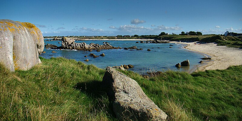
Plouescat (; ) is a commune in the Finistère department of Brittany in north-western France. It is a seaside resort, complete with a casino and a large camping and caravanning site, adjacent to its extensive beach of fine, powdery sand. The region is largely agricultural, specialising in artichokes, onions, cauliflowers and potatoes.
OverviewAI-generated
Plouescat is a commune in France, situated within the Finistère department and the arrondissement of Morlaix. It serves as the capital of the canton of Plouescat and is associated with the electoral district of the canton of Saint-Pol-de-Léon. The town shares borders with Cléder and Plounévez-Lochrist. Its official name is Plouescat, with the native label Ploueskad, and its residents are referred to as Plouescatais or Plouescataises.
The area of the commune is 14.79 square kilometers, with an elevation above sea level of 56 meters. The population is recorded as 4,008, comprising 1,623 males and 1,823 females. Plouescat is twinned with the administrative bodies of Wanfried and Braunton. The postal code for the area is 29430, and it operates within the Europe/Paris timezone.
Synthesized by Vinony from 53 facts across 7 sources: Wikidata, Open Meteo, Openweathermap, OpenStreetMap, GeoNames, Vinony graph, Geo. Generated from structured data (not the Wikipedia text) and checked against those facts — may still contain errors.
Weather now
cached 20h ago7-day forecast
via Open-Meteo
Place details
- Locality
- Plouescat
- Region
- Bretagne
- Country
- France
- Population
- 3,891
- Timezone
- Europe/Paris
via OpenStreetMap · GeoNames
Key facts
- French commune.name
- Plouescat
- French commune.native name
- Ploueskad
- French commune.commune status
- Commune
- French commune.image
- Bretagne Finistere Plouescat1 tango7174.jpg
- French commune.caption
- The sea shore near Plouescat
- French commune.image coat of arms
- Blason ville fr Plouescat 29.svg
- French commune.elevation min m
- 0
- French commune.elevation max m
- 56
- French commune.INSEE
- 29185
- French commune.postal code
- 29430
- French commune.arrondissement
- Morlaix
- French commune.canton
- Saint-Pol-de-Léon
- French commune.mayor
- Eric Le Bour
- French commune.term
- 2020–2026
- French commune.intercommunality
- Haut-Léon Communauté
- French commune.area km2
- 14.79
via Wikipedia infobox
Wikidata facts
- Instance of
- commune of France
- Official name
- Plouescat
- Demonym
- Plouescataises
- Country
- France
- Located in
- arrondissement of Morlaix
- Population
- 3554
- Area
- 14.79
- Elevation
- 19
- Time zone
- UTC+01:00
- Capital of
- canton of Plouescat
- Shares border with
- Plounévez-Lochrist
- Official website
- www.mairie-plouescat.fr
- Image
- Plage Plouescat.jpg
Show 11 more facts
- twinned administrative body
- Wanfried
- Commons category
- Plouescat
- postal code
- 29430
- native label
- Ploueskad
- associated electoral district
- canton of Saint-Pol-de-Léon
- male population
- 1623
- female population
- 1823
- P8168
- case
- email address
- mailto:[email protected]
- phone number
- +33-2-98-69-60-13
- fax number
- +33-2-98-61-91-74
via Wikidata · CC0
~3 min read
Encyclopedic overview
8 sectionsContents
- Geography
- Population
- Breton language
- Sights
- International relations
- See also
- References
- External links
Plouescat (; ) is a commune in the Finistère department of Brittany in north-western France. It is a seaside resort, complete with a casino and a large camping and caravanning site, adjacent to its extensive beach of fine, powdery sand. The region is largely agricultural, specialising in artichokes, onions, cauliflowers and potatoes.
==Geography== Plouescat (Ploueskad), capital of the canton, is part of the district of Morlaix. It is a town in northern Finistère (Penn-ar-Bed), located on the edge of the English Channel, in the country of Léon, on the "Côte des Sables", on the edge of the "Côte des Légendes".
Excerpted from Wikipedia’s “Plouescat” article, available under the CC BY-SA 4.0 licence.
Gallery (6)
On the map
2 mapped locations