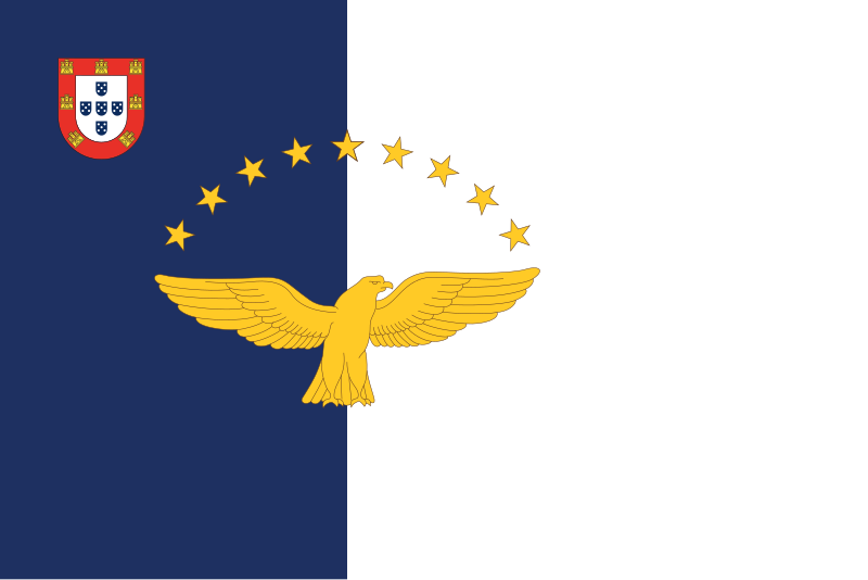
File:Flag_of_the_Azores.svg · Wikimedia Commons · See Wikimedia Commons
Azores
Sign in to saveAlso known as Autonomous Region of Azores, The Azores, Autonomous Region of the Azores, Acores, Açores, Região NUTS III de Portugal, Região NUTS 3 de Portugal, Flemish Islands
The Azores, officially the Autonomous Region of the Azores, is an autonomous region of Portugal in the Atlantic Ocean about west of mainland Portugal. Together with Madeira, it is one of the two autonomous regions of Portugal and a special territory of the European Union. It is the westernmost point and region of Portugal.
The Azores is an autonomous region of Portugal located in the Atlantic Ocean west of mainland Portugal, making it Portugal's westernmost point. Along with Madeira, it serves as one of Portugal's two autonomous regions and holds special status as a territory of the European Union.
AI-generated from the Wikipedia summary — may contain errors.
Key facts
- Political division.name
- Azores
- Political division.settlement_type
- Autonomous Region of Portugal and outermost region of the European Union
- Political division.official_name
- Autonomous Region of the Azores
- Political division.image_flag
- Flag_of_the_Azores.svg
- Political division.flag_size
- 130px
- Political division.flag_alt
- Blue and white bands, superimposed by golden goshawk and surmounted by nine stars with traditional Portuguese shield in the left corner.
- Political division.flag_link
- Flag of the Azores
- Political division.image_seal
- Coat of arms of the Azores.svg
- Political division.seal_size
- 85px
- Political division.seal_type
- Coat of arms
- Political division.seal_link
- Coat of arms of the Azores
- Political division.named_for
- ()
- Political division.motto
- ()
- Political division.anthem
- ()
- Political division.image_map
- Locator_map_of_Azores_in_EU.svg
- Political division.map_alt
- Location of the Azores within the European Union
- Political division.map_caption
- Location of the Azores within Portugal (dark green) and the European Union (light green)
- Political division.subdivision_type
- Country
via Wikipedia infobox
Research
2,003 papers- A comprehensive overview of the cystic fibrosis on the island of São Miguel (Azores, Portugal).ReviewBMC pediatrics · 2020Rosa J, Gaspar-Silva P, Pacheco P et al.DOI: 10.1186/s12887-019-1903-y
- Lichen novelties from Corvo Island (Azores, Portugal).Biodiversity data journal · 2024Rodrigues AF, Videira SIR, Aptroot A et al.DOI: 10.3897/BDJ.12.e140418
- Marine Invasive Algae's Bioactive Ingredients as a Sustainable Pathway in Cosmetics: The Azores Islands as a Case Study.ReviewMarine drugs · 2024Matos M, Custódio L, Reis CPDOI: 10.3390/md22120575
- Human Settlement and Landscape Anthropization of Remote Oceanic Islands: A Comparison between Rapa Nui (Pacific Ocean) and the Azores (Atlantic Ocean).ReviewPlants (Basel, Switzerland) · 2023Rull VDOI: 10.3390/plants12112089
- Island hitchhikers: pathogen agents of Madeira and Azores ticks.Parasitology research · 2024Rosa F, Silva C, Rodrigues R et al.DOI: 10.1007/s00436-024-08278-y
- Microplastics in beach sediments of the Azores archipelago, NE Atlantic.Marine pollution bulletin · 2024Rodrigues C, Rodríguez Y, Frias J et al.DOI: 10.1016/j.marpolbul.2024.116243
- Updated checklist of Azores Chondrichthyes (Vertebrata: Gnathostomata).Biodiversity data journal · 2021Barcelos LMD, Azevedo JMN, Barreiros JPDOI: 10.3897/BDJ.9.e62813
- Ataxia in families from the Azores.The New England journal of medicine · 1977Dawson DMDOI: 10.1056/NEJM197706302962614
via PubMed
Wikidata facts
- Instance of
- Outermost region
- Part of
- Macaronesia
- Has part
- Flores Island
- Official name
- Açores
- Demonym
- azoriana
- Country
- Portugal
- Located in
- Portugal
- Capital
- Horta
- Currency
- euro
- Population
- 236440
- Area
- 2322
- Elevation
- 2351
- Time zone
- UTC±00:00
- Body of water
- North Atlantic Ocean
- Highest point
- Mount Pico
- Official website
- www.azores.gov.pt
- Image
- Açores 2010-07-19 (5047589237).jpg
- Licence plate code
- P
- Mains voltage
- 220
- Patron saint
- Holy Spirit
Show 14 more facts
- topic's main category
- Category:Azores
- maritime identification digits
- 204
- Commons category
- Azores
- Commons gallery
- Azores
- category of associated people
- Category:People from the Azores
- category for people born here
- Q8081745
- inception
- 1976-00-00
- owner of
- Estádio de São Miguel
- native label
- Açores
- language used
- Portuguese
- P11012
- zero
- member of
- Assembly of European Regions
Sources (11)
via Wikidata · CC0
~53 min read
Encyclopedic overview
42 sectionsContents
- History
- Discovery
- Early settlement
- Flemish settlers
- 1522 earthquake and recovery
- Portuguese succession crisis of 1580
- English raids of 1589 and 1598
- Iberian Union
- Overpopulation and emigration
- Liberal Wars of 1828–1834
- Arbitrary district divisions 1836–1976
- Modern period
- Geography
- Geology
- Mountains
- Volcanoes
- Earthquakes
- Biodiversity
- Climate
- 'Azores High' anticyclone
- Köppen classification
- Temperatures, humidity, and sunshine
- Hurricanes
- Economy
- Sustainability
- Transport
- Aviation
- Marine transportation
- Demographics
- Population
- Emigration
- Government and politics
- Foreign relations and defence
- Culture
- Religious societies and festivals
- International visitors
- Sport
- See also
- Notes
- References
- Further reading
- External links
The Azores, officially the Autonomous Region of the Azores, is an autonomous region of Portugal in the Atlantic Ocean about west of mainland Portugal. Together with Madeira, it is one of the two autonomous regions of Portugal and a special territory of the European Union. It is the westernmost point and region of Portugal.
The Azores is an archipelago composed of nine volcanic islands in the Macaronesia region of the North Atlantic Ocean. There are nine major Azorean islands and an islet cluster, in three main groups. These are Flores and Corvo to the west; Graciosa, Terceira, São Jorge, Pico, and Faial in the centre; and São Miguel, Santa Maria, and the Formigas islets to the east. They extend for more than and lie in a northwest–southeast direction. All the islands have volcanic origins, although some, such as Santa Maria, have had no recorded activity in the time since the islands were settled several centuries ago. Mount Pico on the island of Pico is the highest point in Portugal, at . If measured from their base at the bottom of the ocean to their peaks, the Azores are among the tallest mountains on the planet. The Azores are located at the seismically active Azores triple junction plate boundary where the North American plate, Eurasian plate and Nubian plate meet.
Excerpted from Wikipedia’s “Azores” article, available under the CC BY-SA 4.0 licence.
Gallery (632)
On the map
31 mapped locations
Available in 120 languages
- Español
- Français
- Deutsch
- 中文
- 日本語
- Русский
- Português
- Italiano
- العربية
- Afrikaans
- Albanian
- Albanian
- Amharic
- Aragonese
- Armenian
- Asturian
- Azerbaijani
- Bahasa Indonesia
Show 101 more
- Bangla
- Basque
- be_x_old
- Belarusian
- Bosnian
- Breton
- Bulgarian
- Catalan
- Cebuano
- Central Kurdish
- Chechen
- Cornish
- Corsican
- Croatian
- Czech
- Danish
- Egyptian Arabic
- Esperanto
- Estonian
- Extremaduran
- Faroese
- Filipino
- Finnish
- Gagauz
- Galician
- Georgian
- Greek
- Haitian Creole
- Hakka Chinese
- Hebrew
- Hungarian
- Icelandic
- Ido
- Igbo
- Interlingua
- Interlingue
- Irish
- Javanese
- Kazakh
- Kyrgyz
- Ladino
- Latin
- Latvian
- Ligurian
- Limburgish
- Lithuanian
- Luxembourgish
- Macedonian
- Malagasy
- Malay
- Marathi
- Mazanderani
- Mingrelian
- Mirandese
- nds_nl
- Nederlands
- Northern Frisian
- Norwegian
- Norwegian Nynorsk
- Novial
- Occitan
- Ossetic
- Papiamento
- Polski
- Romanian
- Rusyn
- Sardinian
- Saterland Frisian
- Scots
- Serbian
- Serbian (Latin)
- Sicilian
- simple
- Slovak
- Slovenian
- Sundanese
- Svenska
- Swahili
- Tajik
- Tamil
- Tatar
- Tiếng Việt
- Türkçe
- Ukrainian
- Upper Sorbian
- Urdu
- Uzbek
- Waray
- Welsh
- West Flemish
- Western Frisian
- Western Panjabi
- Wu Chinese
- Yiddish
- Yoruba
- Zeelandic
- zh_min_nan
- zh_yue
- فارسی
- ไทย
- 한국어
via Wikidata sitelinks · CC0