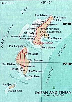
File:Map_Saipan_Tinian_islands_closer.jpg · Wikimedia Commons · See Wikimedia Commons
Tinian
Sign in to saveAlso known as Tinian Island, Tenian-shima
Pacific island, part of the Northern Mariana Islands, United States
Key facts
- Location
- Pacific Ocean
- Archipelago
- Marianas
- Area
- 101.22 km (39.08 sq mi)
- Highest elevation
- 187 m (614 ft)
- Highest point
- Mount Kastiyu
- Commonwealth
- Northern Mariana Islands
- Largest settlement
- San Jose
- Population
- 2,044 (2020)
via Wikipedia infobox
Wikidata facts
- Instance of
- locality
- Part of
- Mariana Islands
- Country
- United States
- Located in
- Northern Mariana Islands
- Continent
- Insular Oceania
- Population
- 3136
- Area
- 101.01
- Time zone
- UTC+10:00
- Body of water
- Pacific Ocean
- Image
- Saipan Tinian aerial map.jpg
Show 4 more facts
- postal code
- 96952
- Commons category
- Tinian
- topic's main category
- Category:Tinian, Northern Mariana Islands
- located in/on physical feature
- Mariana Islands
via Wikidata · CC0
~19 min read
Encyclopedic overview
Tinian (/ˈtɪniən, ˌtiːniˈɑːn/; Chamorro: Tini'an) is one of the three principal islands of the Commonwealth of the Northern Mariana Islands (CNMI). Together with uninhabited neighboring Aguiguan, it forms Tinian Municipality, one of the four constituent municipalities of the Northern Marianas. Tinian's largest village is San Jose. Tinian is just south of Saipan, the most populated island, and north of Rota. The island has many World War II historical sites, cattle ranches, and beaches. There are hotels, resorts, and a golf course. A 5-star casino operated from 1998 to 2015.
Saipan is reached by a short airplane ride or a charter boat.
Excerpted from Wikipedia’s “Tinian” article, available under the CC BY-SA 4.0 licence.