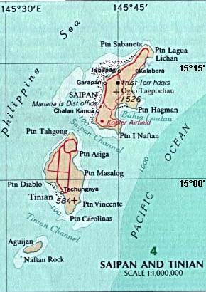
File:Map_Saipan_Tinian_islands_closer.jpg · Wikimedia Commons · See Wikimedia Commons
In the Vinony graph
Within Vinony's link graph, Tinian is referenced by 941 other articles, and connects out to Northern Mariana Islands, World War II and nuclear weapon.
The entry is geolocated on the map.
It sits within the topics Atomic bombings of Hiroshima and Nagasaki, Former German colonies and Geography of the Northern Mariana Islands.
Its subject is documented across 44 Wikipedia language editions.
Key facts
- Location
- Pacific Ocean
- Archipelago
- Marianas
- Area
- 101.22 km (39.08 sq mi)
- Highest elevation
- 187 m (614 ft)
- Highest point
- Mount Kastiyu
- Commonwealth
- Northern Mariana Islands
- Largest settlement
- San Jose
- Population
- 2,044 (2020)
via Wikipedia infobox
Wikidata facts
- Instance of
- locality
- Part of
- Mariana Islands
- Country
- United States
- Located in
- Northern Mariana Islands
- Continent
- Insular Oceania
- Population
- 3136
- Area
- 101.01
- Time zone
- UTC+10:00
- Body of water
- Pacific Ocean
- Image
- Saipan Tinian aerial map.jpg
Show 4 more facts
- postal code
- 96952
- Commons category
- Tinian
- topic's main category
- Category:Tinian, Northern Mariana Islands
- located in/on physical feature
- Mariana Islands
via Wikidata · CC0
Article · Español
Tinián es una de las tres islas principales de la Mancomunidad de las Islas Marianas del Norte, actualmente bajo soberanía estadounidense. Tiene una extensión de 101 km² y su principal localidad es el pueblo de San José. A ocho kilómetros en dirección noreste se encuentra la vecina isla de Saipán, que acoge la capital del archipiélago, y a siete al suroeste la deshabitada Aguiján.
Abstract from DBpedia / Wikipedia · CC BY-SA