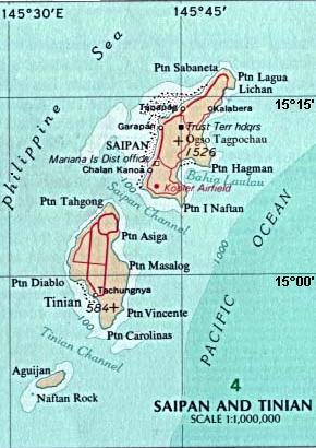
File:Map_Saipan_Tinian_islands_closer.jpg · Wikimedia Commons · See Wikimedia Commons
تينيان
Sign in to saveAlso known as Tinian Island, Tenian-shima
إحدى الجزر الرئيسية الثلاث في كومنولث جزر ماريانا الشمالية
In the Vinony graph
Within Vinony's link graph, تينيان is referenced by 941 other articles, and connects out to Northern Mariana Islands, World War II and nuclear weapon.
The entry is geolocated on the map.
Vinony files it under Atomic bombings of Hiroshima and Nagasaki, Former German colonies and Geography of the Northern Mariana Islands.
Its subject is documented across 44 Wikipedia language editions.
Key facts
- Location
- Pacific Ocean
- Archipelago
- Marianas
- Area
- 101.22 km (39.08 sq mi)
- Highest elevation
- 187 m (614 ft)
- Highest point
- Mount Kastiyu
- Commonwealth
- Northern Mariana Islands
- Largest settlement
- San Jose
- Population
- 2,044 (2020)
via Wikipedia infobox
Wikidata facts
- Instance of
- locality
- Part of
- Mariana Islands
- Country
- United States
- Located in
- Northern Mariana Islands
- Continent
- Insular Oceania
- Population
- 3136
- Area
- 101.01
- Time zone
- UTC+10:00
- Body of water
- Pacific Ocean
- Image
- Saipan Tinian aerial map.jpg
Show 4 more facts
- postal code
- 96952
- Commons category
- Tinian
- topic's main category
- Category:Tinian, Northern Mariana Islands
- located in/on physical feature
- Mariana Islands
via Wikidata · CC0
Article · العربية
تينيان (بالإنجليزية: Tenian؛ وكانت تُعرف فيما مضى بالاسم الياباني: تينيان-شيما، 天 仁 安 島) هي إحدى الجزر الرئيسية الثلاث في كومنولث جزر ماريانا الشمالية. تُشكل جنبًا إلى جنب مع جزيرة المجاورة غير المأهولة، بلدية تينيان، واحدة من أربع بلديات مؤسسة في شمال ماريانا. تعد سان خوسيه أكبر قرية في تينيان.
Abstract from DBpedia / Wikipedia · CC BY-SA