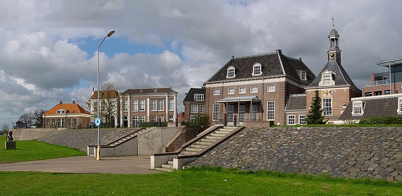
File:Tiel_waterpoort_C.jpg · Wikimedia Commons · See Wikimedia Commons
270px|thumb|Dutch Topographic map of Tiel (town), as of March 2014 Tiel () is a municipality and a town in the middle of the Netherlands. The town is enclosed by the Waal river and the Linge river to the South and the North, and the Amsterdam-Rhine Canal to the East. Tiel comprises the population centres Kapel-Avezaath, Tiel and Wadenoijen. The city was founded in the 5th century CE.
In the Vinony graph
Vinony's link graph records 359 inbound references to تیل, and connects out to municipality of the Netherlands, Netherlands and London.
The entry is geolocated on the map in NL, across 3 mapped points.
It is catalogued under topics including Cities in the Netherlands, Municipalities of Gelderland and Populated places in Gelderland.
Vinony links it to 45 Wikipedia language editions.
Key facts
- Settlement.name
- Tiel
- Settlement.settlement_type
- Municipality
- Settlement.image_skyline
- Tiel waterpoort C.jpg
- Settlement.image_caption
- Fortified dyke in Tiel
- Settlement.image_flag
- Flag of Tiel.svg
- Settlement.flag_size
- 100x67px
- Settlement.image_shield
- Coat of arms of Tiel.svg
- Settlement.shield_size
- 100x80px
- Settlement.image_map
- Map - NL - Municipality code 0281 (2009).svg
- Settlement.map_alt
- Highlighted position of Tiel in a municipal map of Gelderland
- Settlement.map_caption
- Location in Gelderland
- Settlement.pushpin_map
- Netherlands#Europe
- Settlement.pushpin_map_caption
- Location within the Netherlands##Location within Europe
- Settlement.pushpin_relief
- 1
- Settlement.subdivision_type
- Country
- Settlement.subdivision_name
- Netherlands
- Settlement.subdivision_type1
- Province
- Settlement.subdivision_name1
- Gelderland
via Wikipedia infobox
Official website

Link to the official site · 2,712 chars · not written by Vinony
Wikidata facts
- Instance of
- municipality of the Netherlands
- Demonym
- Tielenaar
- Country
- Netherlands
- Located in
- Gelderland
- Population
- 41920
- Area
- 32.63
- Elevation
- 7
- Time zone
- UTC+01:00
- Body of water
- Amsterdam–Rhine Canal
- Shares border with
- Geldermalsen
- Official website
- www.tiel.nl
- Image
- Tiel City Walls West.JPG
- Households
- 17212
- Dialing code
- 0344
Show 10 more facts
- postal code
- 4013–4014
- topic's main category
- Category:Tiel
- Commons category
- Tiel
- category for people born here
- Category:Births in Tiel
- contains settlement
- Kerk-Avezaath
- category of associated people
- Category:People from Tiel
- email address
- mailto:[email protected]
- described by source
- Encyclopædia Britannica 11th edition
- phone number
- +31344637111
- P8168
- Gardon
Sources (15)
via Wikidata · CC0
Gallery (21)
On the map
3 mapped locations